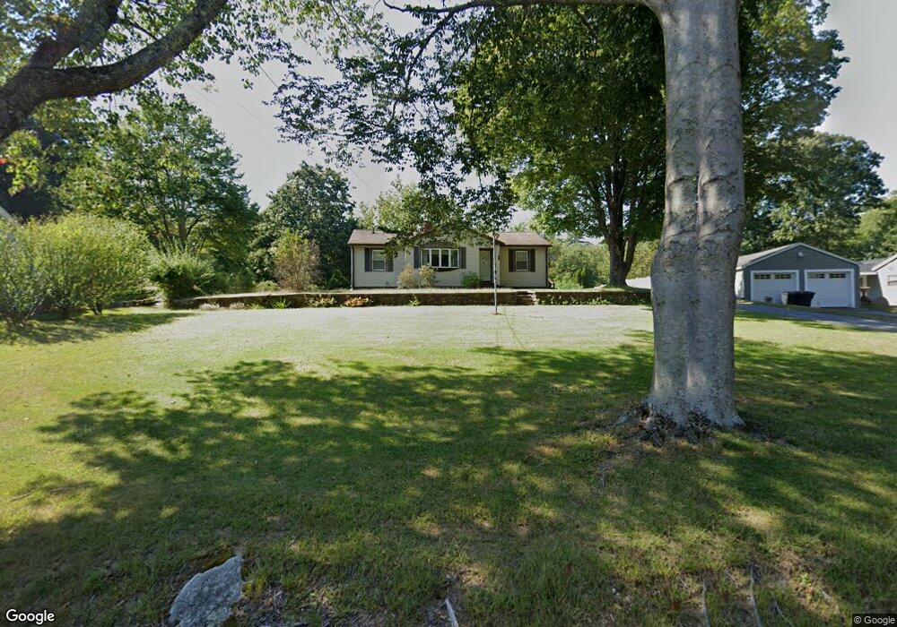
31 Arnold Rd Fiskdale, MA 01518
Estimated Value: $352,000 - $380,897
3
Beds
3
Baths
1,351
Sq Ft
$273/Sq Ft
Est. Value
About This Home
This home is located at 31 Arnold Rd, Fiskdale, MA 01518 and is currently estimated at $369,224, approximately $273 per square foot. 31 Arnold Rd is a home located in Worcester County with nearby schools including Burgess Elementary School, Tantasqua Regional Junior High School, and Tantasqua Regional High School.
Ownership History
Date
Name
Owned For
Owner Type
Purchase Details
Closed on
Aug 23, 2017
Sold by
Southall Vincent
Bought by
Burdin Debra
Current Estimated Value
Purchase Details
Closed on
Mar 3, 2017
Sold by
Southall Ella M
Bought by
Southall Vincent A
Purchase Details
Closed on
Jun 21, 1978
Bought by
Burdin Ella M
Create a Home Valuation Report for This Property
The Home Valuation Report is an in-depth analysis detailing your home's value as well as a comparison with similar homes in the area
Home Values in the Area
Average Home Value in this Area
Purchase History
| Date | Buyer | Sale Price | Title Company |
|---|---|---|---|
| Burdin Debra | -- | -- | |
| Southall Vincent A | -- | -- | |
| Burdin Ella M | -- | -- |
Source: Public Records
Mortgage History
| Date | Status | Borrower | Loan Amount |
|---|---|---|---|
| Previous Owner | Burdin Ella M | $3,000 |
Source: Public Records
Tax History Compared to Growth
Tax History
| Year | Tax Paid | Tax Assessment Tax Assessment Total Assessment is a certain percentage of the fair market value that is determined by local assessors to be the total taxable value of land and additions on the property. | Land | Improvement |
|---|---|---|---|---|
| 2025 | $4,738 | $297,400 | $72,300 | $225,100 |
| 2024 | $4,315 | $261,700 | $70,800 | $190,900 |
| 2023 | $4,089 | $226,300 | $62,100 | $164,200 |
| 2022 | $3,930 | $205,200 | $56,000 | $149,200 |
| 2021 | $3,467 | $182,300 | $53,400 | $128,900 |
| 2020 | $3,467 | $182,300 | $53,400 | $128,900 |
| 2019 | $216 | $167,800 | $55,100 | $112,700 |
| 2018 | $3,095 | $159,200 | $52,500 | $106,700 |
| 2017 | $2,951 | $152,100 | $50,500 | $101,600 |
| 2016 | $2,964 | $154,300 | $49,000 | $105,300 |
| 2015 | $2,909 | $151,200 | $49,000 | $102,200 |
Source: Public Records
Map
Nearby Homes
- 7 Crescent Way Unit 315
- 7 Meadow View Ln
- 24 Cricket Dr
- 621 Main St
- 76 Stallion Hill Rd
- 16 Summit Ave
- 6 Cedar Pond Dr
- 51-A Seneca Ln
- 368 Main St
- 43 Mountain Brook Rd
- 22 Mountain Brook Rd
- 50 Beach Ave
- 146-A. Cedar St
- 146-A Cedar St
- 73 New Boston Rd
- 6 Jerry Rd
- 213 Cedar St
- 2 Sprucedale Dr
- 314 The Trail
- 9 Haynes St