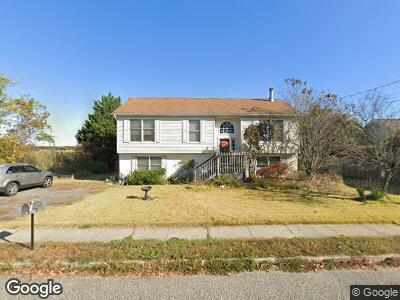
31 Defeo Ln Somers Point, NJ 08244
Estimated Value: $394,000 - $530,000
--
Bed
--
Bath
2,326
Sq Ft
$200/Sq Ft
Est. Value
About This Home
This home is located at 31 Defeo Ln, Somers Point, NJ 08244 and is currently estimated at $464,405, approximately $199 per square foot. 31 Defeo Ln is a home located in Atlantic County with nearby schools including Mainland Regional High School, ChARTer TECH High School for the Performing Arts, and Gospel of Grace Christian School.
Ownership History
Date
Name
Owned For
Owner Type
Purchase Details
Closed on
Dec 15, 2005
Sold by
Reves Suzanne
Bought by
Thomas Nancy and Thomas Charles
Current Estimated Value
Purchase Details
Closed on
Mar 31, 1999
Sold by
One Sixteen Inc
Bought by
Reves Suzanne L
Home Financials for this Owner
Home Financials are based on the most recent Mortgage that was taken out on this home.
Original Mortgage
$147,155
Interest Rate
6.83%
Purchase Details
Closed on
Oct 7, 1998
Sold by
Alaska Seaboard Partners Ltd Partnership
Bought by
One Sixteen Inc
Purchase Details
Closed on
Aug 11, 1998
Sold by
Ward Winifred Dayle
Bought by
Alaska Seaboard Partners Ltd Partnership
Purchase Details
Closed on
Mar 31, 1989
Sold by
Woodlot Corporation
Bought by
Ward Winifred Dayle
Create a Home Valuation Report for This Property
The Home Valuation Report is an in-depth analysis detailing your home's value as well as a comparison with similar homes in the area
Home Values in the Area
Average Home Value in this Area
Purchase History
| Date | Buyer | Sale Price | Title Company |
|---|---|---|---|
| Thomas Nancy | $395,000 | -- | |
| Reves Suzanne L | $154,900 | Commonwealth Land Title Ins | |
| One Sixteen Inc | $72,500 | Commonwealth Land Title Ins | |
| Alaska Seaboard Partners Ltd Partnership | -- | -- | |
| Ward Winifred Dayle | $34,500 | -- |
Source: Public Records
Mortgage History
| Date | Status | Borrower | Loan Amount |
|---|---|---|---|
| Open | Thomas Nancy Lou | $525,000 | |
| Previous Owner | Reves Suzanne L | $21,210 | |
| Previous Owner | Reves Suzanne L | $147,155 |
Source: Public Records
Tax History Compared to Growth
Tax History
| Year | Tax Paid | Tax Assessment Tax Assessment Total Assessment is a certain percentage of the fair market value that is determined by local assessors to be the total taxable value of land and additions on the property. | Land | Improvement |
|---|---|---|---|---|
| 2024 | $7,857 | $233,700 | $69,500 | $164,200 |
| 2023 | $7,308 | $233,700 | $69,500 | $164,200 |
| 2022 | $7,308 | $233,700 | $69,500 | $164,200 |
| 2021 | $7,191 | $233,700 | $69,500 | $164,200 |
| 2020 | $7,034 | $233,700 | $69,500 | $164,200 |
| 2019 | $6,822 | $233,700 | $69,500 | $164,200 |
| 2018 | $6,918 | $233,700 | $69,500 | $164,200 |
| 2017 | $6,661 | $233,700 | $69,500 | $164,200 |
| 2016 | $6,347 | $233,700 | $69,500 | $164,200 |
| 2015 | $6,280 | $233,700 | $69,500 | $164,200 |
| 2014 | $6,060 | $233,700 | $69,500 | $164,200 |
Source: Public Records
Map
Nearby Homes
- 12 Woodlot Ct
- 98 New Rd
- 18 Cooper Dr
- 61 Chapman Blvd
- 226 Bethel Rd
- 124 Princeton Rd
- 303 Buffalo Ave
- 202 Steelman Ave
- 308 Kirklin Ave
- 1009 Massachusetts Ave
- 2109 West Ave
- 29 Bucknell Rd
- 25 Bucknell Rd
- 206 Frances Ave
- 715 Massachusetts Ave
- 205 Columbus Place
- 2212 Wabash Ave
- 13 Princeton Rd
- 36 W Johnson Ave
- 335 Shore Rd