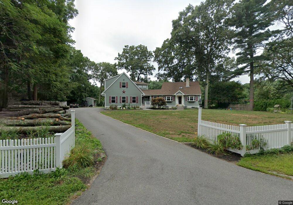
31 Leland Rd Norfolk, MA 02056
Estimated Value: $767,000 - $1,045,000
3
Beds
3
Baths
2,966
Sq Ft
$311/Sq Ft
Est. Value
About This Home
This home is located at 31 Leland Rd, Norfolk, MA 02056 and is currently estimated at $923,350, approximately $311 per square foot. 31 Leland Rd is a home located in Norfolk County with nearby schools including H. Olive Day School, Freeman-Kennedy School, and Woodside Montessori Academy.
Ownership History
Date
Name
Owned For
Owner Type
Purchase Details
Closed on
Feb 29, 1996
Sold by
Mackey Carol A
Bought by
Marland John R
Current Estimated Value
Home Financials for this Owner
Home Financials are based on the most recent Mortgage that was taken out on this home.
Original Mortgage
$102,000
Outstanding Balance
$3,998
Interest Rate
7.02%
Mortgage Type
Purchase Money Mortgage
Estimated Equity
$919,352
Create a Home Valuation Report for This Property
The Home Valuation Report is an in-depth analysis detailing your home's value as well as a comparison with similar homes in the area
Home Values in the Area
Average Home Value in this Area
Purchase History
| Date | Buyer | Sale Price | Title Company |
|---|---|---|---|
| Marland John R | $120,000 | -- |
Source: Public Records
Mortgage History
| Date | Status | Borrower | Loan Amount |
|---|---|---|---|
| Open | Marland John R | $102,000 |
Source: Public Records
Tax History Compared to Growth
Tax History
| Year | Tax Paid | Tax Assessment Tax Assessment Total Assessment is a certain percentage of the fair market value that is determined by local assessors to be the total taxable value of land and additions on the property. | Land | Improvement |
|---|---|---|---|---|
| 2025 | $12,581 | $787,800 | $393,700 | $394,100 |
| 2024 | $11,335 | $728,000 | $352,200 | $375,800 |
| 2023 | $9,672 | $589,400 | $306,700 | $282,700 |
| 2022 | $8,831 | $485,200 | $239,300 | $245,900 |
| 2021 | $8,660 | $481,400 | $235,500 | $245,900 |
| 2020 | $8,304 | $445,500 | $231,500 | $214,000 |
| 2019 | $8,293 | $453,400 | $231,500 | $221,900 |
| 2018 | $8,072 | $433,500 | $231,500 | $202,000 |
| 2017 | $7,958 | $436,800 | $231,500 | $205,300 |
| 2016 | $7,952 | $439,800 | $231,500 | $208,300 |
| 2015 | $7,309 | $413,900 | $220,200 | $193,700 |
| 2014 | $7,101 | $407,400 | $220,200 | $187,200 |
Source: Public Records
Map
Nearby Homes
- 99 Leland Rd
- 10 Populatic Street Extension
- 311 Eagles Nest Way Unit 311
- 312 Eagles Nest Way Unit 312
- 12 Ariana Ln
- 10 Macarthur Ave
- 98 Myrtle St
- 19 Mulberry Ln
- 41 Myrtle St
- 37 Daniels St
- 33 Daniels St
- 28 Myrtle St
- 48 Leanne Way Unit 48
- 83 Oliver Pond Cir Unit 7
- 91 Oliver Pond Cir Unit 3
- 1 Granite Dr
- 425 Village St
- 229 Bent St
- 17 Farm St
- 242 Farm St