Estimated Value: $192,000 - $250,000
3
Beds
2
Baths
1,536
Sq Ft
$144/Sq Ft
Est. Value
About This Home
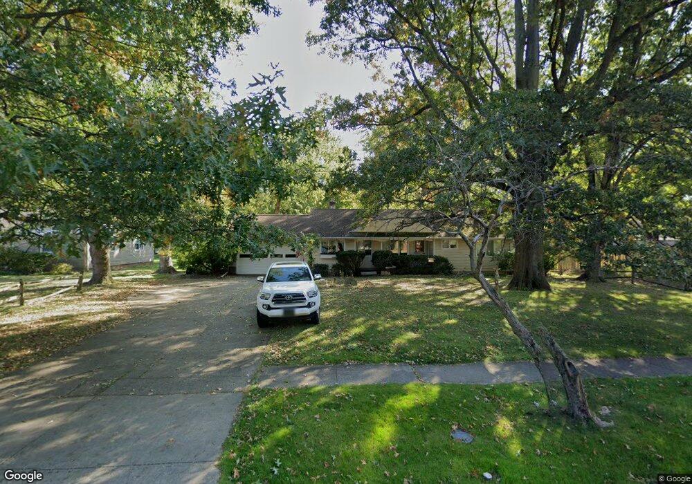
This home is located at 31 Manning Dr, Berea, OH 44017 and is currently estimated at $221,000, approximately $143 per square foot. 31 Manning Dr is a home located in Cuyahoga County with nearby schools including Grindstone Elementary School, Berea-Midpark Middle School, and Berea-Midpark High School.
Ownership History
Date
Name
Owned For
Owner Type
Purchase Details
Closed on
Jul 18, 2025
Sold by
Kaczmarczyk Lisa and Kaczmarczyk Nicholas
Bought by
Kirkendall Van and Kirkendall Kathalee
Current Estimated Value
Purchase Details
Closed on
Jun 5, 1990
Sold by
Mock Bruce D and Mock Lana K
Bought by
Mock Bruce D
Purchase Details
Closed on
Sep 13, 1982
Sold by
Dugan Thomas R
Bought by
Mock Bruce D and Mock Lana K
Purchase Details
Closed on
Jul 19, 1978
Sold by
Dearborn Kenneth H
Bought by
Dugan Thomas R
Purchase Details
Closed on
Jan 1, 1975
Bought by
Dearborn Kenneth H
Create a Home Valuation Report for This Property
The Home Valuation Report is an in-depth analysis detailing your home's value as well as a comparison with similar homes in the area
Home Values in the Area
Average Home Value in this Area
Purchase History
| Date | Buyer | Sale Price | Title Company |
|---|---|---|---|
| Kirkendall Van | $100,000 | Gateway Title | |
| Mock Bruce D | -- | -- | |
| Mock Bruce D | $86,600 | -- | |
| Dugan Thomas R | $80,000 | -- | |
| Dearborn Kenneth H | -- | -- |
Source: Public Records
Tax History
| Year | Tax Paid | Tax Assessment Tax Assessment Total Assessment is a certain percentage of the fair market value that is determined by local assessors to be the total taxable value of land and additions on the property. | Land | Improvement |
|---|---|---|---|---|
| 2024 | $4,221 | $72,765 | $22,190 | $50,575 |
| 2023 | $4,315 | $62,480 | $17,990 | $44,490 |
| 2022 | $4,288 | $62,475 | $17,990 | $44,485 |
| 2021 | $4,252 | $62,480 | $17,990 | $44,490 |
| 2020 | $4,062 | $52,960 | $15,260 | $37,700 |
| 2019 | $3,954 | $151,300 | $43,600 | $107,700 |
| 2018 | $3,850 | $52,960 | $15,260 | $37,700 |
| 2017 | $4,069 | $50,860 | $20,300 | $30,560 |
| 2016 | $4,039 | $50,860 | $20,300 | $30,560 |
| 2015 | $4,016 | $50,860 | $20,300 | $30,560 |
| 2014 | $4,016 | $53,520 | $21,390 | $32,130 |
Source: Public Records
Map
Nearby Homes
- 9003 Prospect Rd
- 516 Fair St
- 275 Quarrystone Ln
- 49 Monroe St
- 8902 Lincolnshire Blvd
- 21032 Breckenridge Ln
- 458 Sprague Rd
- 647 Tampico Ct Unit 7
- 10020 Fair Rd
- 388 Fairwood Cir
- 23004 Chandlers Ln Unit 4-344
- 57 Riverside Dr
- 23002 Chandlers Ln Unit 223
- 23002 Chandlers Ln Unit 221
- 216 Kraft St
- 209 Gibson St
- 23155 Wainwright Terrace
- 300 West St
- 211 W Bridge St
- 287 Edgewood Dr
- 41 Manning Dr
- 19 Manning Dr
- 659 Prospect St
- 692 S Point Trail
- 693 S Point Trail Unit H31
- 691 S Point Trail Unit H32
- 690 S Point Trail
- 17 Manning Dr
- 696 S Point Trail Unit 133
- 695 S Point Trail Unit 136
- 697 S Point Trail Unit I35
- 694 S Point Trail
- 695 S Point Trail Unit I36
- 694 S Point Trail Unit I34
- 665 Prospect St
- 20 Manning Dr
- 61 Manning Dr
- 32 Manning Dr
- 687 S Point Trail Unit G25
- 688 S Point Trail
Your Personal Tour Guide
Ask me questions while you tour the home.