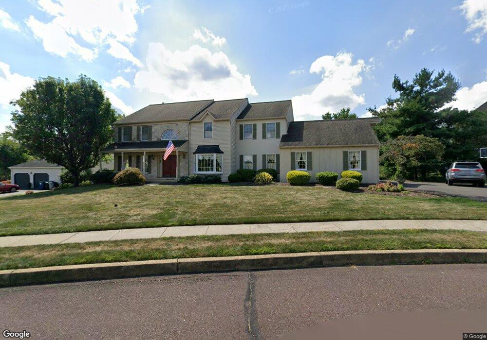
31 Marian Cir Chalfont, PA 18914
Estimated Value: $689,000 - $852,000
4
Beds
3
Baths
3,504
Sq Ft
$224/Sq Ft
Est. Value
About This Home
This home is located at 31 Marian Cir, Chalfont, PA 18914 and is currently estimated at $783,681, approximately $223 per square foot. 31 Marian Cir is a home located in Bucks County with nearby schools including Pine Run Elementary School, Tohickon Middle School, and Central Bucks High School-West.
Ownership History
Date
Name
Owned For
Owner Type
Purchase Details
Closed on
Feb 25, 1994
Sold by
Furfari James L and Furfari Susan L
Bought by
Keane Timothy M and Yoder Keane Kelly Ann
Current Estimated Value
Home Financials for this Owner
Home Financials are based on the most recent Mortgage that was taken out on this home.
Original Mortgage
$203,150
Interest Rate
6.9%
Purchase Details
Closed on
Sep 6, 1991
Bought by
Furfari James L and Furfari Susan L
Create a Home Valuation Report for This Property
The Home Valuation Report is an in-depth analysis detailing your home's value as well as a comparison with similar homes in the area
Home Values in the Area
Average Home Value in this Area
Purchase History
| Date | Buyer | Sale Price | Title Company |
|---|---|---|---|
| Keane Timothy M | $282,500 | -- | |
| Furfari James L | $275,000 | -- |
Source: Public Records
Mortgage History
| Date | Status | Borrower | Loan Amount |
|---|---|---|---|
| Closed | Keane Timothy M | $203,150 |
Source: Public Records
Tax History Compared to Growth
Tax History
| Year | Tax Paid | Tax Assessment Tax Assessment Total Assessment is a certain percentage of the fair market value that is determined by local assessors to be the total taxable value of land and additions on the property. | Land | Improvement |
|---|---|---|---|---|
| 2025 | $9,812 | $47,950 | $6,520 | $41,430 |
| 2024 | $9,812 | $54,800 | $6,520 | $48,280 |
| 2023 | $9,400 | $54,800 | $6,520 | $48,280 |
| 2022 | $9,297 | $54,800 | $6,520 | $48,280 |
| 2021 | $9,195 | $54,800 | $6,520 | $48,280 |
| 2020 | $9,195 | $54,800 | $6,520 | $48,280 |
| 2019 | $9,141 | $54,800 | $6,520 | $48,280 |
| 2018 | $9,141 | $54,800 | $6,520 | $48,280 |
| 2017 | $9,004 | $54,800 | $6,520 | $48,280 |
| 2016 | $9,004 | $54,800 | $6,520 | $48,280 |
| 2015 | -- | $54,800 | $6,520 | $48,280 |
| 2014 | -- | $54,800 | $6,520 | $48,280 |
Source: Public Records
Map
Nearby Homes
- 10 Hellberg Ave
- 425 Elm Cir
- 1075 Patrick Place Unit 75
- 245 Coventry Rd
- 172 Chestnut St
- The Brookhaven Plan at Barclay Hill
- The Brentwood Plan at Barclay Hill
- The Banbury Plan at Barclay Hill
- 84 Curley Mill Rd
- 40 E Butler Ave
- 60 Becker Dr Unit 27
- 62 Becker Dr Unit 28
- 58 Becker Dr Unit 26
- 64 Becker Dr Unit 29
- 79 Becker Dr
- 34 Warren Dr Unit 16
- 32 Warren Dr Unit 15
- 30 Warren Dr Unit 14
- The Hamilton Plan at The Reserve at Chalfont
- The Jordan Plan at The Reserve at Chalfont