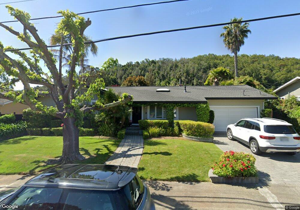
31 Robinhood Dr San Rafael, CA 94901
Glenwood NeighborhoodEstimated Value: $1,116,101 - $1,489,000
3
Beds
2
Baths
1,356
Sq Ft
$986/Sq Ft
Est. Value
About This Home
This home is located at 31 Robinhood Dr, San Rafael, CA 94901 and is currently estimated at $1,336,775, approximately $985 per square foot. 31 Robinhood Dr is a home located in Marin County with nearby schools including Glenwood Elementary School, James B. Davidson Middle School, and San Rafael High School.
Ownership History
Date
Name
Owned For
Owner Type
Purchase Details
Closed on
Dec 23, 1997
Sold by
Bjursten Bo Tr Etal and Bjursten Elisabeth Tr Etal
Bought by
Bjursten Bo and Bjursten Gun
Current Estimated Value
Home Financials for this Owner
Home Financials are based on the most recent Mortgage that was taken out on this home.
Original Mortgage
$177,000
Interest Rate
6.71%
Create a Home Valuation Report for This Property
The Home Valuation Report is an in-depth analysis detailing your home's value as well as a comparison with similar homes in the area
Home Values in the Area
Average Home Value in this Area
Purchase History
| Date | Buyer | Sale Price | Title Company |
|---|---|---|---|
| Bjursten Bo | -- | First American Title Co | |
| Bjursten Bo | -- | First American Title Co |
Source: Public Records
Mortgage History
| Date | Status | Borrower | Loan Amount |
|---|---|---|---|
| Closed | Bjursten Bo | $177,000 |
Source: Public Records
Tax History Compared to Growth
Tax History
| Year | Tax Paid | Tax Assessment Tax Assessment Total Assessment is a certain percentage of the fair market value that is determined by local assessors to be the total taxable value of land and additions on the property. | Land | Improvement |
|---|---|---|---|---|
| 2025 | $3,826 | $147,445 | $40,438 | $107,007 |
| 2024 | $3,826 | $144,554 | $39,645 | $104,909 |
| 2023 | $3,680 | $141,720 | $38,868 | $102,852 |
| 2022 | $3,545 | $138,942 | $38,106 | $100,836 |
| 2021 | $3,485 | $136,218 | $37,359 | $98,859 |
| 2020 | $3,400 | $134,821 | $36,976 | $97,845 |
| 2019 | $3,201 | $132,178 | $36,251 | $95,927 |
| 2018 | $3,149 | $129,587 | $35,540 | $94,047 |
| 2017 | $3,058 | $127,046 | $34,843 | $92,203 |
| 2016 | $2,935 | $124,555 | $34,160 | $90,395 |
| 2015 | $2,815 | $122,685 | $33,647 | $89,038 |
| 2014 | $2,674 | $120,282 | $32,988 | $87,294 |
Source: Public Records
Map
Nearby Homes
- 46 Rollingwood Dr
- 52 Cottonwood Dr
- 83 Cottonwood Dr
- 32 Knight Dr
- 175 Rollingwood Dr
- 70 Dunfries Terrace
- 836 Point San Pedro Rd
- 24 Bonnie Banks Way
- 68 Bayharbor Way
- 177 Oak Dr
- 8 Riviera Place
- 15 Junipero Serra Ave
- 350 Margarita Dr
- 121 San Marino Dr
- 126 San Marino Dr
- 15 Sulgrave Ln
- 31 Gold Hill Grade
- 120 Fairway Dr
- 220 Deer Park Ave
- 48 Porto Bello Dr
- 35 Robinhood Dr
- 27 Robinhood Dr
- 42 Rollingwood Dr
- 38 Rollingwood Dr
- 32 Robinhood Dr
- 39 Robinhood Dr
- 23 Robinhood Dr
- 28 Robinhood Dr
- 36 Robinhood Dr
- 34 Rollingwood Dr
- 50 Rollingwood Dr
- 3 Brentwood Dr
- 40 Robinhood Dr
- 43 Robinhood Dr
- 19 Robinhood Dr
- 30 Rollingwood Dr
- 7 Briarwood Dr
- 54 Rollingwood Dr
- 11 Briarwood Dr
- 11 Brentwood Dr