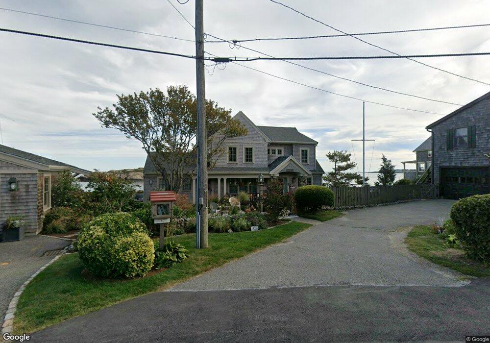
31 Salt Island Rd Gloucester, MA 01930
East Gloucester NeighborhoodEstimated Value: $1,248,000 - $4,124,000
4
Beds
2
Baths
2,556
Sq Ft
$1,092/Sq Ft
Est. Value
About This Home
This home is located at 31 Salt Island Rd, Gloucester, MA 01930 and is currently estimated at $2,790,527, approximately $1,091 per square foot. 31 Salt Island Rd is a home located in Essex County with nearby schools including East Gloucester Elementary School, Ralph B O'maley Middle School, and Gloucester High School.
Ownership History
Date
Name
Owned For
Owner Type
Purchase Details
Closed on
Dec 15, 2017
Sold by
Fifield Douglas T and Fifield Linda S
Bought by
Fifield Ft
Current Estimated Value
Purchase Details
Closed on
Dec 29, 2010
Sold by
Briarcliff Rt
Bought by
Fifield Douglas T and Fifield Linda S
Create a Home Valuation Report for This Property
The Home Valuation Report is an in-depth analysis detailing your home's value as well as a comparison with similar homes in the area
Home Values in the Area
Average Home Value in this Area
Purchase History
| Date | Buyer | Sale Price | Title Company |
|---|---|---|---|
| Fifield Ft | -- | -- | |
| Fifield Douglas T | $54,500 | -- |
Source: Public Records
Mortgage History
| Date | Status | Borrower | Loan Amount |
|---|---|---|---|
| Previous Owner | Fifield Douglas T | $600,000 | |
| Previous Owner | Fifield Douglas T | $70,000 |
Source: Public Records
Tax History Compared to Growth
Tax History
| Year | Tax Paid | Tax Assessment Tax Assessment Total Assessment is a certain percentage of the fair market value that is determined by local assessors to be the total taxable value of land and additions on the property. | Land | Improvement |
|---|---|---|---|---|
| 2025 | $27,757 | $2,855,700 | $1,748,500 | $1,107,200 |
| 2024 | $26,976 | $2,772,500 | $1,665,300 | $1,107,200 |
| 2023 | $25,283 | $2,387,400 | $1,420,500 | $966,900 |
| 2022 | $24,430 | $2,082,700 | $1,236,100 | $846,600 |
| 2021 | $23,564 | $1,894,200 | $1,123,800 | $770,400 |
| 2020 | $23,380 | $1,896,200 | $1,123,800 | $772,400 |
| 2019 | $22,277 | $1,755,500 | $1,071,500 | $684,000 |
| 2018 | $21,607 | $1,671,100 | $1,045,400 | $625,700 |
| 2017 | $21,035 | $1,594,800 | $995,300 | $599,500 |
| 2016 | $20,147 | $1,480,300 | $952,000 | $528,300 |
| 2015 | $14,851 | $1,088,000 | $930,400 | $157,600 |
Source: Public Records
Map
Nearby Homes
- 26 Marina Dr
- 33 Highview Rd
- 29 Harrison Ave
- 10 Amero Ct
- 20 Haskell St
- 9 Rocky Pasture Rd
- 20 Calder St
- 86 E Main St
- 97 E Main St
- 100 E Main St
- 36 Links Rd
- 30 Chapel St Unit B
- 22 Taylor St Unit 1
- 197 E Main St
- 197 E Main St Unit 1
- 197 E Main St Unit 2
- 197 E Main St Unit 1 & 2
- 27 Hodgkins Rd
- 160 Prospect St Unit 3
- 4 Mount Vernon St
- 29 Salt Island Rd
- 30 Salt Island Rd
- 27 Salt Island Rd
- 33 Salt Island Rd
- 32 Salt Island Rd
- 34 Salt Island Rd
- 25 Salt Island Rd
- 28 Salt Island Rd
- 26 Salt Island Rd Unit WINTER
- 26 Salt Island Rd
- 35 Salt Island Rd
- 38 Salt Island Rd
- 4 Prospect St
- 4 Prospect St Unit 1
- 4 Prospect St Unit 2
- 37 Salt Island Rd
- 7 Cliff Rd
- 7 Cliff Rd Unit 7
- 23 Salt Island Rd
- 24 Salt Island Rd