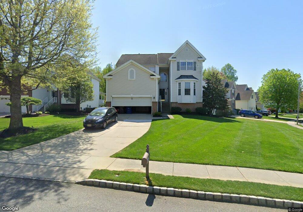
31 Stoneham Dr Delran, NJ 08075
Estimated Value: $564,395 - $641,000
Studio
--
Bath
2,422
Sq Ft
$249/Sq Ft
Est. Value
About This Home
This home is located at 31 Stoneham Dr, Delran, NJ 08075 and is currently estimated at $603,849, approximately $249 per square foot. 31 Stoneham Dr is a home located in Burlington County with nearby schools including Millbridge Elementary School, Delran Intermediate School, and Delran Middle School.
Ownership History
Date
Name
Owned For
Owner Type
Purchase Details
Closed on
Nov 8, 2011
Sold by
Brogan Carl M and Brogan Joseph P
Bought by
Brogan Carla M and Brogan Joseph P
Current Estimated Value
Purchase Details
Closed on
Apr 30, 2004
Sold by
Brogan Joseph P and Brogan Carla M
Bought by
Brogan Carla M
Purchase Details
Closed on
May 30, 2002
Sold by
D R Horton Inc New Jersey
Bought by
Brogan Joseph P and Brogan Carla M
Home Financials for this Owner
Home Financials are based on the most recent Mortgage that was taken out on this home.
Original Mortgage
$130,000
Outstanding Balance
$55,316
Interest Rate
6.9%
Estimated Equity
$548,533
Create a Home Valuation Report for This Property
The Home Valuation Report is an in-depth analysis detailing your home's value as well as a comparison with similar homes in the area
Home Values in the Area
Average Home Value in this Area
Purchase History
| Date | Buyer | Sale Price | Title Company |
|---|---|---|---|
| Brogan Carla M | -- | None Available | |
| Brogan Carla M | -- | -- | |
| Brogan Joseph P | $231,290 | Commonwealth Land Title |
Source: Public Records
Mortgage History
| Date | Status | Borrower | Loan Amount |
|---|---|---|---|
| Open | Brogan Joseph P | $130,000 |
Source: Public Records
Tax History
| Year | Tax Paid | Tax Assessment Tax Assessment Total Assessment is a certain percentage of the fair market value that is determined by local assessors to be the total taxable value of land and additions on the property. | Land | Improvement |
|---|---|---|---|---|
| 2025 | $12,015 | $302,200 | $56,000 | $246,200 |
| 2024 | $11,907 | $302,200 | $56,000 | $246,200 |
| 2023 | $11,907 | $302,200 | $56,000 | $246,200 |
| 2022 | $11,753 | $302,200 | $56,000 | $246,200 |
| 2021 | $11,759 | $302,200 | $56,000 | $246,200 |
| 2020 | $11,734 | $302,200 | $56,000 | $246,200 |
| 2019 | $11,626 | $302,200 | $56,000 | $246,200 |
| 2018 | $11,432 | $302,200 | $56,000 | $246,200 |
| 2017 | $11,251 | $302,200 | $56,000 | $246,200 |
| 2016 | $11,085 | $302,200 | $56,000 | $246,200 |
| 2015 | $10,900 | $302,200 | $56,000 | $246,200 |
| 2014 | $10,426 | $302,200 | $56,000 | $246,200 |
Source: Public Records
Map
Nearby Homes
- 3 Aster Ct
- 144 Natalie Rd
- 148 Natalie Rd Unit 148
- 3 Dewberry Ln
- 19 Foxglove Dr Unit 19
- 27 Foxglove Dr Unit 27
- 44 Foxglove Dr Unit CO44
- 342 Huntington Dr Unit 342
- 88 Foxglove Dr Unit 88
- 265 Rosebay Ct Unit 265
- 4 Weatherly Rd
- 17 Ridgeview Rd
- 0 0 Swarthmore Dr
- 1 Echo Ave
- 203 Congressional Ct
- 359 Creek Rd
- 751 Garwood Rd
- 712 Kimberly Dr
- 4304 Bridgeboro Rd
- 801 Cox Rd
- 3 Grande Blvd
- 29 Stoneham Dr
- 33 Stoneham Dr
- 5 Grande Blvd
- 20 Stoneham Dr
- 27 Stoneham Dr
- 22 Stoneham Dr
- 2 Liberty Trail
- 18 Stoneham Dr
- 7 Grande Blvd
- 24 Stoneham Dr
- 35 Stoneham Dr
- 25 Stoneham Dr
- 16 Stoneham Dr
- 7 Woodyfield Ln
- 9 Grande Blvd
- 5 Woodyfield Ln
- 26 Stoneham Dr
- 4 Liberty Trail
- 9 Woodyfield Ln
Your Personal Tour Guide
Ask me questions while you tour the home.