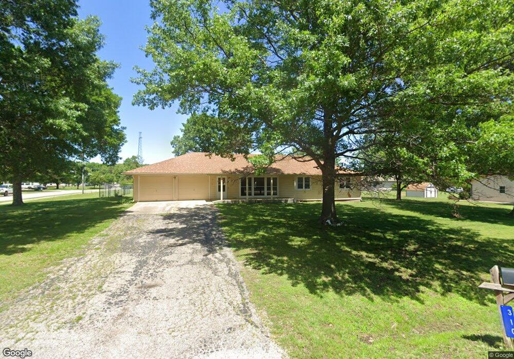
310 E 11th St Auburn, KS 66402
Estimated Value: $241,416 - $277,000
3
Beds
3
Baths
1,782
Sq Ft
$143/Sq Ft
Est. Value
About This Home
This home is located at 310 E 11th St, Auburn, KS 66402 and is currently estimated at $255,104, approximately $143 per square foot. 310 E 11th St is a home located in Shawnee County with nearby schools including Auburn Elementary School, Washburn Rural Middle School, and Washburn Rural High School.
Ownership History
Date
Name
Owned For
Owner Type
Purchase Details
Closed on
Apr 29, 2008
Sold by
Coe Karen K and Kidwell James Donald
Bought by
Manker James R and Manker Janice L
Current Estimated Value
Home Financials for this Owner
Home Financials are based on the most recent Mortgage that was taken out on this home.
Original Mortgage
$50,000
Interest Rate
6.6%
Mortgage Type
New Conventional
Create a Home Valuation Report for This Property
The Home Valuation Report is an in-depth analysis detailing your home's value as well as a comparison with similar homes in the area
Purchase History
| Date | Buyer | Sale Price | Title Company |
|---|---|---|---|
| Manker James R | $58,750 | Capital Title Ins Co |
Source: Public Records
Mortgage History
| Date | Status | Borrower | Loan Amount |
|---|---|---|---|
| Previous Owner | Manker James R | $50,000 |
Source: Public Records
Tax History
| Year | Tax Paid | Tax Assessment Tax Assessment Total Assessment is a certain percentage of the fair market value that is determined by local assessors to be the total taxable value of land and additions on the property. | Land | Improvement |
|---|---|---|---|---|
| 2025 | $3,571 | $24,891 | -- | -- |
| 2023 | $3,571 | $23,014 | $0 | $0 |
| 2022 | $3,195 | $20,548 | $0 | $0 |
| 2021 | $2,803 | $18,681 | $0 | $0 |
| 2020 | $2,638 | $17,791 | $0 | $0 |
| 2019 | $2,562 | $17,272 | $0 | $0 |
| 2018 | $2,382 | $16,770 | $0 | $0 |
| 2017 | $2,265 | $15,871 | $0 | $0 |
| 2014 | $2,246 | $15,560 | $0 | $0 |
Source: Public Records
Map
Nearby Homes
- 450 N Milton St
- 310 Kellogg Ln
- 000 SW 77th St
- 10632 SW Auburn Rd
- 0000 SW Wanamaker Rd
- 9020 SW Wanamaker Rd
- 11277 S Auburn Rd
- 0000 SW 77th St
- 10729 SW Hoch Rd
- 0003 SW Hoch Rd
- 0001 SW Hoch Rd
- 0000 SW Hoch Rd
- 0002 SW Hoch Rd
- 0004 SW Hoch Rd
- 6800 Blk SW Valencia Rd
- 0000 SW 53rd St
- 11086 S Wanamaker Rd
- 7406 SW Docking Rd
- 8618 SW 51st St
- 0000 SW Gage Blvd
- 1131 N Franklin St
- 0 E 11th St
- 321 E 11th St
- 1130 Hanover Rd
- 1151 N Franklin St
- 251 E 11th St
- 1120 N Franklin St
- 1051 N Franklin St
- 1140 N Franklin St
- 1200 Hanover Rd
- 757 N Hanover St
- 0 SW Hanover St Unit 156680
- 0 SW Hanover St Unit 159776
- 1160 N Franklin St
- 1111 Harrison St
- 1131 Harrison St
- 1021 N Franklin St
- 1151 Harrison St
- 1061 Harrison St
- 1127 Hanover Rd
Your Personal Tour Guide
Ask me questions while you tour the home.