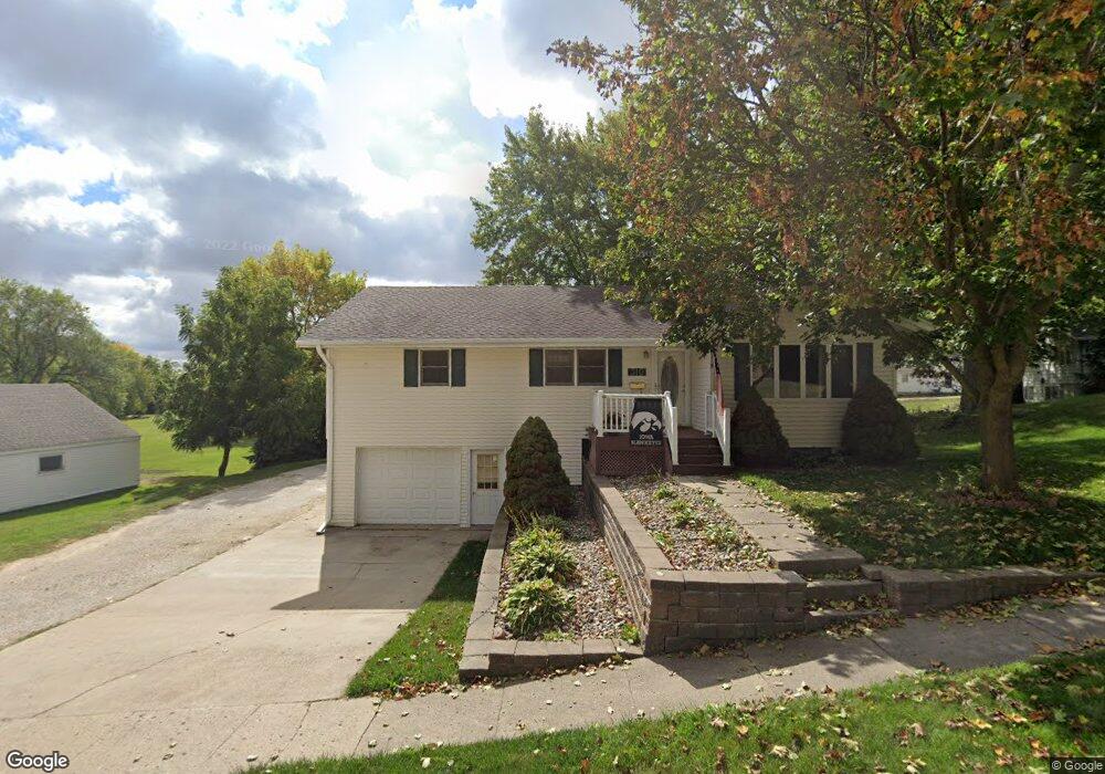
310 E 12th St Carroll, IA 51401
Estimated Value: $209,000 - $254,000
4
Beds
2
Baths
1,464
Sq Ft
$161/Sq Ft
Est. Value
About This Home
This home is located at 310 E 12th St, Carroll, IA 51401 and is currently estimated at $235,853, approximately $161 per square foot. 310 E 12th St is a home located in Carroll County with nearby schools including Fairview Elementary School, Adams Elementary School, and Carroll Middle School.
Ownership History
Date
Name
Owned For
Owner Type
Purchase Details
Closed on
Oct 27, 2009
Sold by
The Estate Of Raymond E Sapp
Bought by
Hoffman Donald M
Current Estimated Value
Home Financials for this Owner
Home Financials are based on the most recent Mortgage that was taken out on this home.
Original Mortgage
$88,000
Interest Rate
4.96%
Mortgage Type
New Conventional
Create a Home Valuation Report for This Property
The Home Valuation Report is an in-depth analysis detailing your home's value as well as a comparison with similar homes in the area
Home Values in the Area
Average Home Value in this Area
Purchase History
| Date | Buyer | Sale Price | Title Company |
|---|---|---|---|
| Hoffman Donald M | $123,500 | Security Title & Investment |
Source: Public Records
Mortgage History
| Date | Status | Borrower | Loan Amount |
|---|---|---|---|
| Closed | Hoffman Donald M | $88,000 |
Source: Public Records
Tax History
| Year | Tax Paid | Tax Assessment Tax Assessment Total Assessment is a certain percentage of the fair market value that is determined by local assessors to be the total taxable value of land and additions on the property. | Land | Improvement |
|---|---|---|---|---|
| 2025 | $2,834 | $244,650 | $27,540 | $217,110 |
| 2024 | $28 | $216,090 | $27,540 | $188,550 |
| 2023 | $2,599 | $216,090 | $27,540 | $188,550 |
| 2022 | $2,466 | $170,090 | $27,540 | $142,550 |
| 2021 | $2,466 | $170,090 | $27,540 | $142,550 |
| 2020 | $2,524 | $170,090 | $27,540 | $142,550 |
| 2019 | $2,482 | $170,090 | $27,540 | $142,550 |
| 2018 | $2,338 | $170,090 | $27,540 | $142,550 |
| 2017 | $2,338 | $163,175 | $20,630 | $142,545 |
| 2016 | $2,184 | $152,500 | $0 | $0 |
| 2015 | $2,184 | $146,480 | $0 | $0 |
| 2014 | $2,072 | $146,480 | $0 | $0 |
Source: Public Records
Map
Nearby Homes
- 1108 N Main St
- 1102 N Main St
- 926 N Court St
- 641 Alta Vista Dr
- 804 N Clark St
- 1320 N Adams St
- 827 N Main St
- 1515 N Main St
- 1546 Olive St
- 1601 N Main St
- 1509 Birch St
- 1059 Amy Ave
- 1010 High Ridge Rd
- 1068 Amy Ave
- 265 Perch St
- 746 Granada Rd
- 1014 Mockingbird Dr
- 19383 U S 30
- 1816 N Main St
- 1306 Simon Ave
- 1128 N Clark St
- 320 E 12th St
- 1206 N Clark St
- 1208 N Clark St
- 1210 N Clark St
- 1122 N Clark St
- 1204 N Clark St
- 1112 N Clark St
- 311 E 11th St
- 401 E 11th St
- 1205 N Clark St Unit 3C
- 1127 N Clark St
- 1108 N Clark St
- 1121 N Clark St
- 1207 N Clark St
- 1209 N Clark St Unit 3E
- 1151 N Grant Rd
- 1115 N Clark St
- 1102 N Clark St
- 325 E 11th St