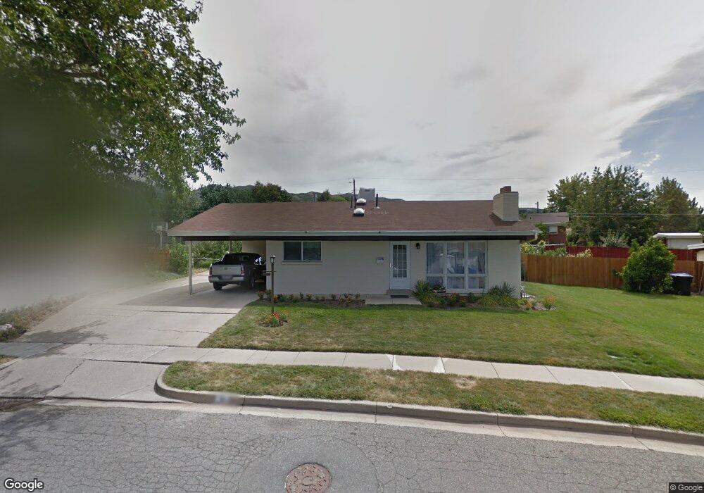
310 E 1650 S Bountiful, UT 84010
Estimated Value: $474,000 - $545,000
5
Beds
2
Baths
1,073
Sq Ft
$479/Sq Ft
Est. Value
About This Home
This home is located at 310 E 1650 S, Bountiful, UT 84010 and is currently estimated at $513,575, approximately $478 per square foot. 310 E 1650 S is a home located in Davis County with nearby schools including Valley View School, Mueller Park Junior High School, and Bountiful High School.
Ownership History
Date
Name
Owned For
Owner Type
Purchase Details
Closed on
Jun 4, 2025
Sold by
Heckaman Jeremy M and Heckaman Erin M
Bought by
Heckaman Erin and Heckaman Jeremy Michael
Current Estimated Value
Home Financials for this Owner
Home Financials are based on the most recent Mortgage that was taken out on this home.
Original Mortgage
$220,000
Outstanding Balance
$219,435
Interest Rate
6.81%
Mortgage Type
New Conventional
Estimated Equity
$294,140
Purchase Details
Closed on
Jul 17, 2012
Sold by
Lowe Cary and Lowe Cary Alan
Bought by
Heckaman Jeremy M and Heckaman Erin M
Home Financials for this Owner
Home Financials are based on the most recent Mortgage that was taken out on this home.
Original Mortgage
$166,250
Interest Rate
3.63%
Mortgage Type
New Conventional
Purchase Details
Closed on
Jan 3, 2011
Sold by
Lowe Youngoak
Bought by
Lowe Cary
Purchase Details
Closed on
Aug 8, 2003
Sold by
Robinson Beverly S and Martin Shellie
Bought by
Robinson Beverly S and Schaugaard Dixie
Create a Home Valuation Report for This Property
The Home Valuation Report is an in-depth analysis detailing your home's value as well as a comparison with similar homes in the area
Purchase History
| Date | Buyer | Sale Price | Title Company |
|---|---|---|---|
| Heckaman Erin | -- | Cottonwood Title | |
| Heckaman Jeremy M | -- | American Secure Tit | |
| Lowe Cary | -- | None Available | |
| Robinson Beverly S | -- | -- |
Source: Public Records
Mortgage History
| Date | Status | Borrower | Loan Amount |
|---|---|---|---|
| Open | Heckaman Erin | $220,000 | |
| Previous Owner | Heckaman Jeremy M | $166,250 |
Source: Public Records
Tax History
| Year | Tax Paid | Tax Assessment Tax Assessment Total Assessment is a certain percentage of the fair market value that is determined by local assessors to be the total taxable value of land and additions on the property. | Land | Improvement |
|---|---|---|---|---|
| 2025 | $2,795 | $249,150 | $139,646 | $109,504 |
| 2024 | $2,616 | $242,550 | $127,037 | $115,513 |
| 2023 | $2,601 | $439,000 | $231,639 | $207,361 |
| 2022 | $2,726 | $253,000 | $127,027 | $125,973 |
| 2021 | $2,288 | $323,000 | $166,347 | $156,653 |
| 2020 | $2,025 | $286,000 | $141,105 | $144,895 |
| 2019 | $2,056 | $284,000 | $142,442 | $141,558 |
| 2018 | $1,897 | $257,000 | $139,480 | $117,520 |
| 2016 | $1,630 | $119,515 | $57,073 | $62,442 |
| 2015 | $1,588 | $109,780 | $57,073 | $52,707 |
| 2014 | $1,627 | $116,410 | $57,073 | $59,337 |
| 2013 | -- | $96,225 | $51,700 | $44,525 |
Source: Public Records
Map
Nearby Homes
- 288 E 1650 S
- 141 E 1650 S
- 380 E 1500 S
- 1886 S Jeri Dr
- 2059 S 350 E Unit 6
- 2038 S 350 E Unit 3
- 295 E 2050 S Unit 1
- 631 E 1700 S
- 296 E 2050 S Unit 2
- 2046 S 350 E Unit 4
- 188 E 2050 S Unit D3
- 2053 S 350 E Unit 7
- 1820 S 50 W
- 2064 S Orchard Dr
- 1761 S Davis Blvd
- 320 E 2100 S
- 285 E 1100 S
- 2 E Wicker Ln
- 2273 S 200 E
- 41 E 2200 S
Your Personal Tour Guide
Ask me questions while you tour the home.