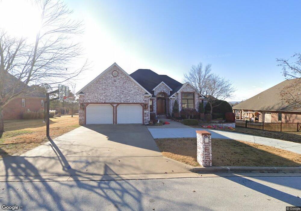
310 Hogan Dr Harrison, AR 72601
Estimated Value: $420,551 - $619,000
5
Beds
4
Baths
4,384
Sq Ft
$111/Sq Ft
Est. Value
About This Home
This home is located at 310 Hogan Dr, Harrison, AR 72601 and is currently estimated at $486,388, approximately $110 per square foot. 310 Hogan Dr is a home located in Boone County with nearby schools including Harrison Kindergarten, Harrison Jr. High School, and Harrison High School.
Ownership History
Date
Name
Owned For
Owner Type
Purchase Details
Closed on
Jan 27, 2011
Sold by
Pratt Jeffrey Lynn and Pratt Angela Jonette
Bought by
Hubbard Robert R and Hubbard Anne A
Current Estimated Value
Home Financials for this Owner
Home Financials are based on the most recent Mortgage that was taken out on this home.
Original Mortgage
$271,920
Outstanding Balance
$8,426
Interest Rate
4.84%
Mortgage Type
New Conventional
Estimated Equity
$477,962
Purchase Details
Closed on
Jul 28, 2008
Sold by
Jackson Jerry T and Jackson Peggy A
Bought by
Pratt Family Trust
Home Financials for this Owner
Home Financials are based on the most recent Mortgage that was taken out on this home.
Original Mortgage
$309,000
Interest Rate
5.99%
Mortgage Type
Adjustable Rate Mortgage/ARM
Purchase Details
Closed on
Jun 15, 1999
Bought by
Jackson
Create a Home Valuation Report for This Property
The Home Valuation Report is an in-depth analysis detailing your home's value as well as a comparison with similar homes in the area
Purchase History
| Date | Buyer | Sale Price | Title Company |
|---|---|---|---|
| Hubbard Robert R | $340,000 | -- | |
| Pratt Family Trust | -- | None Available | |
| Pratt Family Trust | -- | Lenders Title Co | |
| Jackson | $30,000 | -- |
Source: Public Records
Mortgage History
| Date | Status | Borrower | Loan Amount |
|---|---|---|---|
| Open | Hubbard Robert R | $271,920 | |
| Previous Owner | Pratt Family Trust | $309,000 |
Source: Public Records
Tax History
| Year | Tax Paid | Tax Assessment Tax Assessment Total Assessment is a certain percentage of the fair market value that is determined by local assessors to be the total taxable value of land and additions on the property. | Land | Improvement |
|---|---|---|---|---|
| 2025 | $3,399 | $66,640 | $5,000 | $61,640 |
| 2024 | $3,399 | $66,640 | $5,000 | $61,640 |
| 2023 | $3,399 | $66,640 | $5,000 | $61,640 |
| 2022 | $2,902 | $66,640 | $5,000 | $61,640 |
| 2021 | $2,753 | $66,640 | $5,000 | $61,640 |
| 2020 | $2,604 | $58,420 | $5,000 | $53,420 |
| 2019 | $2,622 | $58,420 | $5,000 | $53,420 |
| 2018 | $2,647 | $58,420 | $5,000 | $53,420 |
| 2017 | $2,629 | $58,420 | $5,000 | $53,420 |
| 2016 | $2,629 | $58,420 | $5,000 | $53,420 |
| 2015 | $3,160 | $61,960 | $5,720 | $56,240 |
| 2014 | $2,810 | $61,960 | $5,720 | $56,240 |
Source: Public Records
Map
Nearby Homes
- 1903 Daly Dr
- 307 Pebble Beach Dr
- 86 Lots Round Mountain Estates
- 203 Pebble Beach Dr
- 202 Pebble Beach Dr
- 3107 Belmont Ave Unit 7
- 3101 Belmont Ave
- 1802 Shellie Ln
- 3008 Belmont Ave
- 3000 Belmont Ave
- 1424 Cottonwood Rd
- Lot 3 Cornerstone Way
- Lot 1 Cornerstone Way
- Lot 4 Cornerstone Way
- Lot 2 Cornerstone Way
- 203 Glenview St
- 26 Ozark Dr
- 0 W Hwy 43 Unit 1298701
- 602 Oriole Dr
- 0 Corner of Airport Rd & Hwy 65n Unit 146774
Your Personal Tour Guide
Ask me questions while you tour the home.