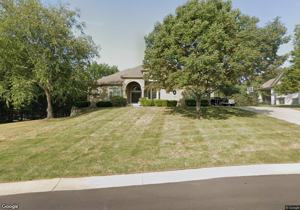
310 NW Rockhill Cir Lees Summit, MO 64081
Estimated Value: $771,000 - $1,165,594
5
Beds
6
Baths
4,932
Sq Ft
$207/Sq Ft
Est. Value
About This Home
This home is located at 310 NW Rockhill Cir, Lees Summit, MO 64081 and is currently estimated at $1,022,149, approximately $207 per square foot. 310 NW Rockhill Cir is a home located in Jackson County with nearby schools including Cedar Creek Elementary School, Pleasant Lea Middle School, and Lee's Summit Senior High School.
Ownership History
Date
Name
Owned For
Owner Type
Purchase Details
Closed on
May 20, 2019
Sold by
Mcspurren Dodi
Bought by
Mcspurren Paul
Current Estimated Value
Purchase Details
Closed on
Oct 23, 2009
Sold by
Hines David Brent and Hines Deborah
Bought by
Mcspurren Paul and Mcspurren Dodi
Purchase Details
Closed on
Jul 22, 2004
Sold by
Koehler Building Co Inc
Bought by
Hines David Brent and Hines Deborah
Create a Home Valuation Report for This Property
The Home Valuation Report is an in-depth analysis detailing your home's value as well as a comparison with similar homes in the area
Home Values in the Area
Average Home Value in this Area
Purchase History
| Date | Buyer | Sale Price | Title Company |
|---|---|---|---|
| Mcspurren Paul | -- | None Available | |
| Mcspurren Paul | -- | Kansas City Title | |
| Hines David Brent | -- | Security Land Title Company |
Source: Public Records
Tax History Compared to Growth
Tax History
| Year | Tax Paid | Tax Assessment Tax Assessment Total Assessment is a certain percentage of the fair market value that is determined by local assessors to be the total taxable value of land and additions on the property. | Land | Improvement |
|---|---|---|---|---|
| 2025 | $11,787 | $186,446 | $22,656 | $163,790 |
| 2024 | $11,702 | $163,248 | $19,456 | $143,792 |
| 2023 | $11,702 | $163,248 | $16,484 | $146,764 |
| 2022 | $11,381 | $140,980 | $18,680 | $122,300 |
| 2021 | $11,616 | $140,980 | $18,680 | $122,300 |
| 2020 | $11,164 | $134,176 | $18,680 | $115,496 |
| 2019 | $10,859 | $134,176 | $18,680 | $115,496 |
| 2018 | $10,184 | $116,776 | $16,258 | $100,518 |
| 2017 | $10,232 | $116,776 | $16,258 | $100,518 |
| 2016 | $10,232 | $116,128 | $18,278 | $97,850 |
| 2014 | $10,644 | $118,424 | $16,479 | $101,945 |
Source: Public Records
Map
Nearby Homes
- 2214 NW Killarney Ln
- 2237 NW Killarney Ln
- 361 NW Patch Ct
- 505 NW Ambersham Dr
- 130 NW Ambersham Dr
- 2090 NW O'Brien Rd
- 2086 NW O'Brien Rd
- 248 SW Winterpark Cir
- 2123 NW Killarney Ln
- Monterey Plan at Reserve at Woodside Ridge
- Oakleigh Plan at Reserve at Woodside Ridge
- Ashland Plan at Reserve at Woodside Ridge
- Bentley Plan at Reserve at Woodside Ridge
- Mariah Plan at Reserve at Woodside Ridge
- Oakshire Plan at Reserve at Woodside Ridge
- Forrester II Plan at Reserve at Woodside Ridge
- Forrester 2824 Plan at Reserve at Woodside Ridge
- Regency Plan at Reserve at Woodside Ridge
- Windsong Plan at Reserve at Woodside Ridge
- Carolina Plan at Reserve at Woodside Ridge
- 314 NW Rockhill Cir
- 306 NW Rockhill Cir
- 311 NW Rockwood Ct
- 325 NW Rockhill Ln
- 315 NW Rockwood Ct
- 318 NW Rockhill Cir
- 302 NW Rockhill Cir
- 319 NW Rockwood Ct
- 321 NW Rockhill Cir
- 317 NW Rockhill Cir
- 329 NW Rockhill Ln
- 2408 NW Riven Rock Trail
- 309 NW Rockhill Cir
- 305 NW Rockhill Cir
- 2412 NW Riven Rock Trail
- 301 NW Rockhill Cir
- 333 NW Rockhill Ln
- 2404 NW Riven Rock Trail
- 316 NW Rockwood Ct
- 308 NW Rockwood Ct