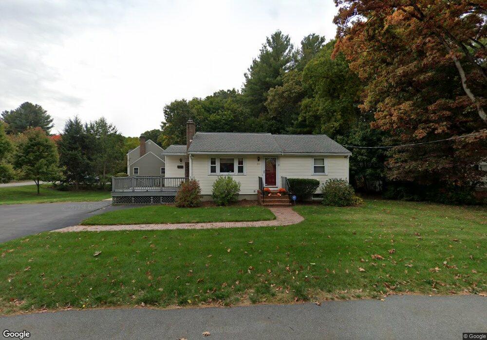
310 Potter Rd Framingham, MA 01701
Saxonville NeighborhoodEstimated Value: $580,000 - $635,000
3
Beds
2
Baths
1,494
Sq Ft
$408/Sq Ft
Est. Value
About This Home
This home is located at 310 Potter Rd, Framingham, MA 01701 and is currently estimated at $609,879, approximately $408 per square foot. 310 Potter Rd is a home located in Middlesex County with nearby schools including Framingham High School and MetroWest Jewish Day School.
Ownership History
Date
Name
Owned For
Owner Type
Purchase Details
Closed on
Mar 9, 2023
Sold by
Bernstein Mark and Nicolazzo-Bernstein Lea A
Bought by
Bernstein Mark J
Current Estimated Value
Purchase Details
Closed on
Aug 29, 2008
Sold by
Dasilveira Claudia Q and Dasilveira Fernando C
Bought by
Bernstein Lea Nicolazzo and Bernstein Mark
Purchase Details
Closed on
May 2, 2006
Sold by
Dasilveira Fernando C
Bought by
Dasilveira Claudia Q and Dasilveira Fernando C
Purchase Details
Closed on
Nov 21, 2005
Sold by
Dibona Gino T and Dibona Kristen
Bought by
Dasilveira Fernando C
Purchase Details
Closed on
Sep 1, 1998
Sold by
Est Voght Barbara and Cann Luanne S
Bought by
Lawn Cheryl A and Blondin Mark
Purchase Details
Closed on
Dec 13, 1993
Sold by
Voght Richard R and Voght Barbara A
Bought by
Oakwood Ct Rt and Depietri Robert J
Create a Home Valuation Report for This Property
The Home Valuation Report is an in-depth analysis detailing your home's value as well as a comparison with similar homes in the area
Home Values in the Area
Average Home Value in this Area
Purchase History
| Date | Buyer | Sale Price | Title Company |
|---|---|---|---|
| Bernstein Mark J | $203,359 | None Available | |
| Bernstein Mark J | $203,359 | None Available | |
| Bernstein Lea Nicolazzo | $299,000 | -- | |
| Bernstein Lea Nicolazzo | $299,000 | -- | |
| Dasilveira Claudia Q | -- | -- | |
| Dasilveira Claudia Q | -- | -- | |
| Dasilveira Fernando C | $398,000 | -- | |
| Dasilveira Fernando C | $398,000 | -- | |
| Lawn Cheryl A | $167,500 | -- | |
| Lawn Cheryl A | $167,500 | -- | |
| Oakwood Ct Rt | $18,831 | -- | |
| Oakwood Ct Rt | $18,831 | -- |
Source: Public Records
Mortgage History
| Date | Status | Borrower | Loan Amount |
|---|---|---|---|
| Previous Owner | Oakwood Ct Rt | $239,000 | |
| Previous Owner | Oakwood Ct Rt | $239,000 |
Source: Public Records
Tax History
| Year | Tax Paid | Tax Assessment Tax Assessment Total Assessment is a certain percentage of the fair market value that is determined by local assessors to be the total taxable value of land and additions on the property. | Land | Improvement |
|---|---|---|---|---|
| 2025 | $6,134 | $513,700 | $271,100 | $242,600 |
| 2024 | $5,719 | $459,000 | $242,200 | $216,800 |
| 2023 | $5,432 | $415,000 | $216,100 | $198,900 |
| 2022 | $5,135 | $373,700 | $196,100 | $177,600 |
| 2021 | $5,012 | $356,700 | $188,500 | $168,200 |
| 2020 | $5,002 | $333,900 | $171,300 | $162,600 |
| 2019 | $4,925 | $320,200 | $171,300 | $148,900 |
| 2018 | $4,814 | $295,000 | $164,900 | $130,100 |
| 2017 | $4,684 | $280,300 | $160,100 | $120,200 |
| 2016 | $4,602 | $264,800 | $160,100 | $104,700 |
| 2015 | $4,601 | $258,200 | $160,700 | $97,500 |
Source: Public Records
Map
Nearby Homes
Your Personal Tour Guide
Ask me questions while you tour the home.