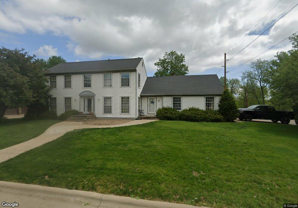
3100 Crystal Dr Burlington, IA 52601
Estimated Value: $354,813 - $415,000
5
Beds
3
Baths
2,659
Sq Ft
$146/Sq Ft
Est. Value
About This Home
This home is located at 3100 Crystal Dr, Burlington, IA 52601 and is currently estimated at $388,203, approximately $145 per square foot. 3100 Crystal Dr is a home located in Des Moines County with nearby schools including Burlington Community High School, Burlington Christian School, and Notre Dame High School.
Ownership History
Date
Name
Owned For
Owner Type
Purchase Details
Closed on
Jul 1, 2005
Sold by
Roberts Timm A and Roberts Donna R
Bought by
Bolander Timothy P and Bolander Paula N
Current Estimated Value
Home Financials for this Owner
Home Financials are based on the most recent Mortgage that was taken out on this home.
Original Mortgage
$115,000
Outstanding Balance
$59,766
Interest Rate
5.69%
Mortgage Type
New Conventional
Estimated Equity
$328,437
Create a Home Valuation Report for This Property
The Home Valuation Report is an in-depth analysis detailing your home's value as well as a comparison with similar homes in the area
Home Values in the Area
Average Home Value in this Area
Purchase History
| Date | Buyer | Sale Price | Title Company |
|---|---|---|---|
| Bolander Timothy P | $225,000 | None Available |
Source: Public Records
Mortgage History
| Date | Status | Borrower | Loan Amount |
|---|---|---|---|
| Open | Bolander Timothy P | $115,000 |
Source: Public Records
Tax History Compared to Growth
Tax History
| Year | Tax Paid | Tax Assessment Tax Assessment Total Assessment is a certain percentage of the fair market value that is determined by local assessors to be the total taxable value of land and additions on the property. | Land | Improvement |
|---|---|---|---|---|
| 2025 | $5,312 | $318,700 | $38,400 | $280,300 |
| 2024 | $5,312 | $283,600 | $38,400 | $245,200 |
| 2023 | $4,636 | $283,600 | $38,400 | $245,200 |
| 2022 | $4,842 | $246,800 | $38,400 | $208,400 |
| 2021 | $4,842 | $246,800 | $38,400 | $208,400 |
| 2020 | $5,164 | $246,800 | $38,400 | $208,400 |
| 2019 | $5,922 | $246,800 | $38,400 | $208,400 |
| 2018 | $5,928 | $265,900 | $36,000 | $229,900 |
| 2017 | $5,990 | $262,800 | $0 | $0 |
| 2016 | $5,786 | $262,800 | $0 | $0 |
| 2015 | $5,786 | $262,800 | $0 | $0 |
| 2014 | $5,860 | $247,700 | $0 | $0 |
Source: Public Records
Map
Nearby Homes
- 2706 Bittersweet Place
- 2405 Bittersweet Place
- 2224 Sunnyside Ave
- 2604 Sunnyside Ave
- 2728 Sunnyside Ave
- 1 Golf Ct
- 2801 Sunnyside Ave
- 2826 Sunnyside Ave
- 10552 Rolling Hills Dr
- 2832 Lesylvia St
- 10591 Rolling Hills Dr
- 2917 Woodland Dr
- 2035 Highland Ave
- 2012 Osborn St
- 2544 Surrey Rd
- 0 Hwy 61 Unit 23351978
- 11161 Iroquois Rd
- 1316 Corse St
- 1209 Virginia Ave
- 1137 Corse St
- 3104 Crystal Dr
- 3101 Crystal Dr
- 3105 Crystal Dr
- 2270 Florence Ave
- 3108 Magnolia Ln
- 3110 Magnolia Ln
- 2280 Florence Ave
- 3112 Crystal Dr
- 3126 Magnolia Ln
- 3118 Magnolia Ln
- 2310 Florence Ave
- 2405 Florence Ave
- 2405 Florence Ave
- 2405 Florence Ave
- 2303 Diamond Dr
- 3201 Crystal Dr
- 3201 Crystal Dr Unit 1
- 2510 Quail Ridge Dr
- 3205 Crystal Dr
- 2411 Florence Ave