Estimated Value: $182,191 - $233,000
4
Beds
1
Bath
1,944
Sq Ft
$104/Sq Ft
Est. Value
About This Home
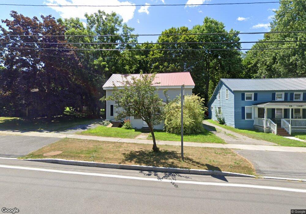
This home is located at 3100 State Route 370, Cato, NY 13033 and is currently estimated at $202,798, approximately $104 per square foot. 3100 State Route 370 is a home located in Cayuga County with nearby schools including Cato-Meridian Elementary School, Cato Meridian Middle School, and Cato-Meridian Senior High School.
Ownership History
Date
Name
Owned For
Owner Type
Purchase Details
Closed on
Nov 6, 2008
Sold by
Drennen Rachel
Bought by
Davis Catherine
Current Estimated Value
Home Financials for this Owner
Home Financials are based on the most recent Mortgage that was taken out on this home.
Original Mortgage
$97,346
Outstanding Balance
$63,900
Interest Rate
6.08%
Mortgage Type
New Conventional
Estimated Equity
$138,898
Purchase Details
Closed on
Mar 24, 2008
Sold by
Us Bank Trustee
Bought by
Drennen Rachel
Purchase Details
Closed on
Jan 3, 2008
Sold by
Doane Terry
Bought by
U.S. Bank National Assoc. As Trustee
Purchase Details
Closed on
Jun 27, 2006
Sold by
Cummins Dean
Bought by
Doane Terry
Purchase Details
Closed on
Feb 10, 2006
Sold by
Cummins Dean
Bought by
Cummins Dean
Purchase Details
Closed on
Aug 29, 2003
Sold by
Cayuga County
Bought by
Cummins Dean D
Purchase Details
Closed on
Jun 7, 1996
Create a Home Valuation Report for This Property
The Home Valuation Report is an in-depth analysis detailing your home's value as well as a comparison with similar homes in the area
Home Values in the Area
Average Home Value in this Area
Purchase History
| Date | Buyer | Sale Price | Title Company |
|---|---|---|---|
| Davis Catherine | $95,400 | Kathleen Joy | |
| Drennen Rachel | $42,900 | Donald Cheney | |
| U.S. Bank National Assoc. As Trustee | $64,900 | Steven Baum, Pc | |
| Doane Terry | $54,960 | Richard Hollembaek | |
| Cummins Dean | -- | Earle Thurston | |
| Cummins Dean D | -- | -- | |
| -- | $4,167 | -- | |
| -- | $4,167 | -- |
Source: Public Records
Mortgage History
| Date | Status | Borrower | Loan Amount |
|---|---|---|---|
| Open | Davis Catherine | $97,346 |
Source: Public Records
Tax History Compared to Growth
Tax History
| Year | Tax Paid | Tax Assessment Tax Assessment Total Assessment is a certain percentage of the fair market value that is determined by local assessors to be the total taxable value of land and additions on the property. | Land | Improvement |
|---|---|---|---|---|
| 2024 | $3,163 | $93,300 | $6,600 | $86,700 |
| 2023 | $3,472 | $93,300 | $6,600 | $86,700 |
| 2022 | $3,454 | $93,300 | $6,600 | $86,700 |
| 2021 | $3,410 | $93,300 | $6,600 | $86,700 |
| 2020 | $2,860 | $93,300 | $6,600 | $86,700 |
| 2019 | $429 | $93,300 | $6,600 | $86,700 |
| 2018 | $2,719 | $93,300 | $6,600 | $86,700 |
| 2017 | $2,628 | $93,300 | $6,600 | $86,700 |
| 2016 | $2,627 | $93,300 | $6,600 | $86,700 |
| 2015 | -- | $93,300 | $6,600 | $86,700 |
| 2014 | -- | $93,300 | $6,600 | $86,700 |
Source: Public Records
Map
Nearby Homes
- 10252 Short Cut Rd
- 11589 Ferris Rd
- 11423 Misty Meadow Dr
- 0 Misty Meadows Dr Unit S1622963
- 11796 Bradt Rd
- 245 Fire Lane 17
- 11696 State Route 34
- 3634 Weller Rd
- 10718 Jordan Rd
- 10546 Bonta Bridge Rd
- 11913 State Route 34
- 10896 Baker Rd
- 107 Fire Lane 13
- 129 Fire Lane 13
- 169 Fire Lane 12
- 2019 State Route 370
- 11256 Drake Rd
- 43 White Anchor Cove
- 10356 Jordan Rd
- 3328 Lysander Rd
- 3100 New York 370
- 3098 State Route 370
- 3106 State Route 370
- 3096 New York 370
- 3112 State Route 370
- 3099 New York 370
- 3107 New York 370
- 3090 State Route 370
- 3111 State Route 370
- 3093 Hollister St
- 3117 State Route 370
- 3111 Hollister St
- 3121 State Route 370
- 3099 Hollister St
- 3118 State Route 370
- 3093 Hollister St
- 11312 Bonta Bridge Rd
- 3117 Hollister St
- 11324 Bonta Bridge Rd
- 11330 Bonta Bridge Rd