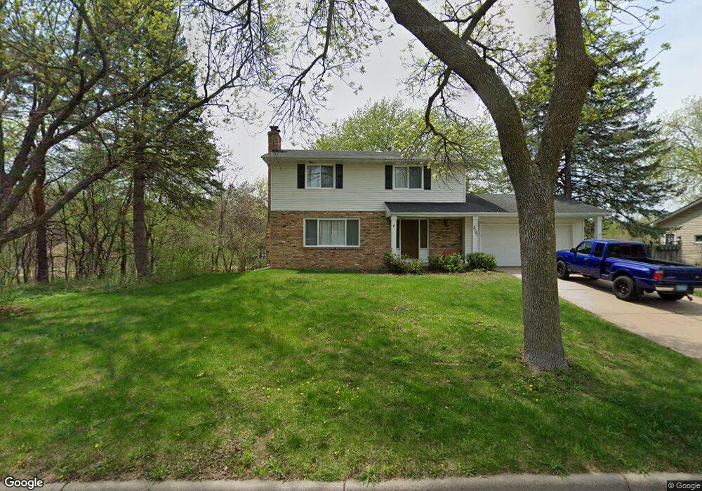
3101 Keating Ct Burnsville, MN 55337
Estimated Value: $390,910 - $416,000
4
Beds
3
Baths
2,479
Sq Ft
$164/Sq Ft
Est. Value
About This Home
This home is located at 3101 Keating Ct, Burnsville, MN 55337 and is currently estimated at $406,978, approximately $164 per square foot. 3101 Keating Ct is a home located in Dakota County with nearby schools including William Byrne Elementary School, Burnsville High School, and Gateway STEM Academy.
Ownership History
Date
Name
Owned For
Owner Type
Purchase Details
Closed on
Dec 10, 2021
Sold by
Freese Jane and Estate Of Jean Dorothy Ramsdel
Bought by
Sun Yuhong
Current Estimated Value
Home Financials for this Owner
Home Financials are based on the most recent Mortgage that was taken out on this home.
Original Mortgage
$252,850
Outstanding Balance
$232,556
Interest Rate
3.11%
Mortgage Type
New Conventional
Estimated Equity
$174,422
Create a Home Valuation Report for This Property
The Home Valuation Report is an in-depth analysis detailing your home's value as well as a comparison with similar homes in the area
Home Values in the Area
Average Home Value in this Area
Purchase History
| Date | Buyer | Sale Price | Title Company |
|---|---|---|---|
| Sun Yuhong | $337,151 | Pillar Title Services |
Source: Public Records
Mortgage History
| Date | Status | Borrower | Loan Amount |
|---|---|---|---|
| Open | Sun Yuhong | $252,850 |
Source: Public Records
Tax History Compared to Growth
Tax History
| Year | Tax Paid | Tax Assessment Tax Assessment Total Assessment is a certain percentage of the fair market value that is determined by local assessors to be the total taxable value of land and additions on the property. | Land | Improvement |
|---|---|---|---|---|
| 2024 | $3,564 | $339,600 | $83,900 | $255,700 |
| 2023 | $3,564 | $338,700 | $83,900 | $254,800 |
| 2022 | $2,898 | $326,900 | $83,700 | $243,200 |
| 2021 | $2,900 | $279,000 | $72,800 | $206,200 |
| 2020 | $2,876 | $265,900 | $69,300 | $196,600 |
| 2019 | $2,734 | $255,100 | $66,000 | $189,100 |
| 2018 | $2,746 | $233,000 | $62,900 | $170,100 |
| 2017 | $2,631 | $227,400 | $59,900 | $167,500 |
| 2016 | $2,765 | $215,800 | $57,100 | $158,700 |
| 2015 | $2,604 | $199,617 | $50,892 | $148,725 |
| 2014 | -- | $196,129 | $49,834 | $146,295 |
| 2013 | -- | $173,784 | $44,703 | $129,081 |
Source: Public Records
Map
Nearby Homes
- 3017 Mcleod St
- 11459 Galtier Dr
- 4427 Cinnamon Ridge Cir
- 4425 Cinnamon Ridge Cir
- 4413 Slater Rd
- 11036 27th Ave S
- 4463 Cinnamon Ridge Cir
- 10934 Southview Dr
- 11017 27th Ave S
- 11902 River Hills Cir
- 11115 Carver Ct
- 3309 Red Oak Cir N
- 11900 Highland View Cir
- 11921 Baypoint Dr
- 2001 Woods Ln
- 3108 Foxpoint Cir
- 4632 Westwood Ln
- 2200 Horizon Rd
- 4165 Old Sibley Hwy
- 11311 W River Hills Dr
- 3009 Keating Ct
- 3007 Keating Ct
- 3100 Keating Ct
- 3006 Keating Ct
- 3102 Keating Ct
- 3005 Keating Ct
- 3104 Keating Ct
- 3004 Keating Ct
- 11528 River Hills Dr
- 3003 Keating Ct
- 11446 Galtier Dr
- 3002 Keating Ct
- 11532 River Hills Dr
- 11450 Galtier Dr
- 11444 Galtier Dr
- 3000 Mcleod St
- 11500 River Hills Dr
- 11405 Keating Ave
- 11403 Keating Ave
- 3001 Keating Ct