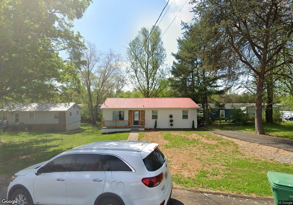
3105 Norman St Morristown, TN 37814
Estimated Value: $198,535 - $260,000
4
Beds
2
Baths
1,472
Sq Ft
$156/Sq Ft
Est. Value
About This Home
This home is located at 3105 Norman St, Morristown, TN 37814 and is currently estimated at $229,384, approximately $155 per square foot. 3105 Norman St is a home with nearby schools including Manley Elementary School, West View Middle School, and Morristown West High School.
Ownership History
Date
Name
Owned For
Owner Type
Purchase Details
Closed on
Jul 12, 2023
Sold by
Helton Patricia
Bought by
Np3 Investments Llc
Current Estimated Value
Purchase Details
Closed on
Dec 30, 2004
Bought by
Helton Doyle E and Helton Patricia
Purchase Details
Closed on
Dec 15, 1999
Bought by
Helton Doyle E
Purchase Details
Closed on
Aug 21, 1992
Bought by
Amos Amos L and Amos E
Purchase Details
Closed on
May 14, 1976
Bought by
Amos John and Amos Frances
Create a Home Valuation Report for This Property
The Home Valuation Report is an in-depth analysis detailing your home's value as well as a comparison with similar homes in the area
Home Values in the Area
Average Home Value in this Area
Purchase History
| Date | Buyer | Sale Price | Title Company |
|---|---|---|---|
| Np3 Investments Llc | $140,000 | Lakeway Title Services | |
| Helton Doyle E | -- | -- | |
| Helton Doyle E | -- | -- | |
| Amos Amos L | $18,500 | -- | |
| Amos John | -- | -- |
Source: Public Records
Tax History Compared to Growth
Tax History
| Year | Tax Paid | Tax Assessment Tax Assessment Total Assessment is a certain percentage of the fair market value that is determined by local assessors to be the total taxable value of land and additions on the property. | Land | Improvement |
|---|---|---|---|---|
| 2024 | $361 | $20,500 | $3,375 | $17,125 |
| 2023 | $361 | $20,500 | $0 | $0 |
| 2022 | $648 | $20,500 | $3,375 | $17,125 |
| 2021 | $648 | $20,500 | $3,375 | $17,125 |
| 2020 | $647 | $20,500 | $3,375 | $17,125 |
| 2019 | $628 | $18,450 | $3,075 | $15,375 |
| 2018 | $582 | $18,450 | $3,075 | $15,375 |
| 2017 | $572 | $18,450 | $3,075 | $15,375 |
| 2016 | $546 | $18,450 | $3,075 | $15,375 |
| 2015 | $508 | $18,450 | $3,075 | $15,375 |
| 2014 | -- | $18,450 | $3,075 | $15,375 |
| 2013 | -- | $19,675 | $0 | $0 |
Source: Public Records
Map
Nearby Homes
- 700 Drinnon Dr
- 3475 Walden Dr
- 3471 Walden Dr
- 801 Colonial Dr
- 2978 Wilshire Blvd
- 725 Barton Dr
- 729 Amanda Harrison Ct
- 3113 Wilshire Blvd
- 2454 Sandstone Dr
- 2444 Sandstone Dr
- 2430 Sandstone Dr
- 2310 Sandstone Dr
- 1086 St Ives Ct
- 1101 Drinnon Dr
- 2045 N Economy Rd Unit A3
- 3721 Meadowland Dr
- 2020 N Economy Rd
- Darwin Plan at Southwood
- Robie Plan at Southwood
- Elston Plan at Southwood