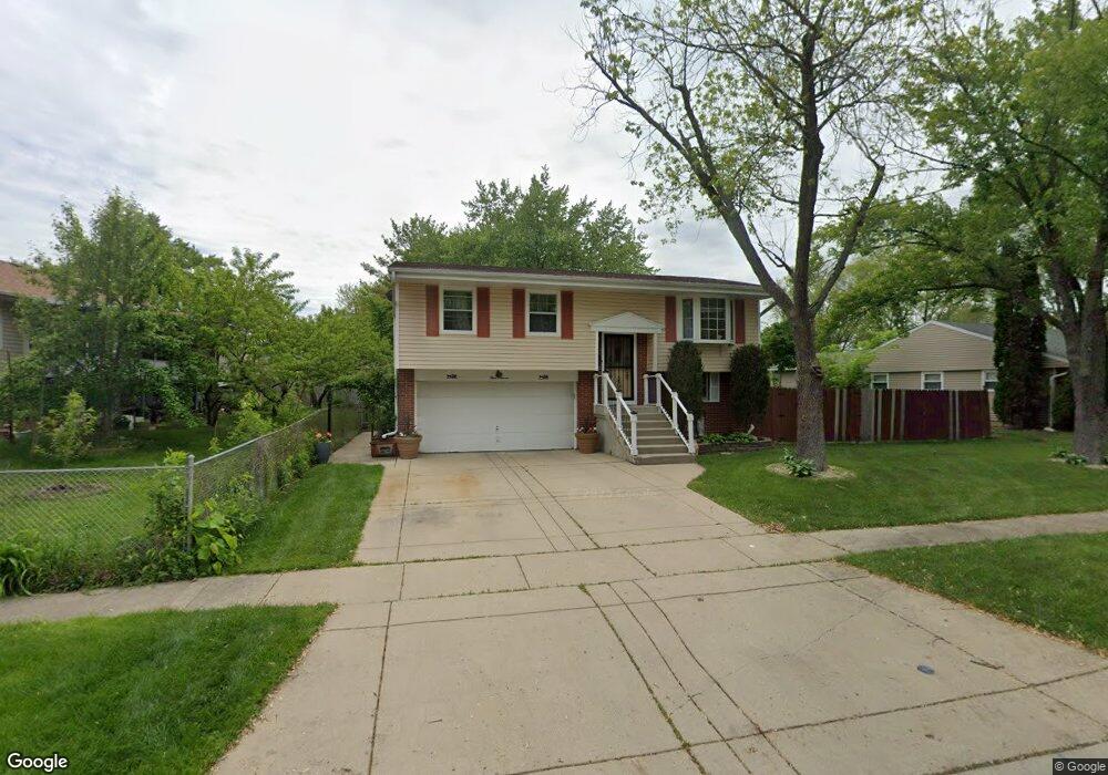
311 E Maxon Ln Streamwood, IL 60107
Woodland Heights NeighborhoodEstimated Value: $306,068 - $314,000
3
Beds
1
Bath
1,262
Sq Ft
$246/Sq Ft
Est. Value
About This Home
This home is located at 311 E Maxon Ln, Streamwood, IL 60107 and is currently estimated at $311,017, approximately $246 per square foot. 311 E Maxon Ln is a home located in Cook County with nearby schools including Oakhill Elementary School, Canton Middle School, and Streamwood High School.
Ownership History
Date
Name
Owned For
Owner Type
Purchase Details
Closed on
Jun 14, 2002
Sold by
Untiedt Lynn
Bought by
Vallejo Armando and Vallejo Virginia
Current Estimated Value
Home Financials for this Owner
Home Financials are based on the most recent Mortgage that was taken out on this home.
Original Mortgage
$177,555
Outstanding Balance
$73,491
Interest Rate
6.93%
Estimated Equity
$237,526
Create a Home Valuation Report for This Property
The Home Valuation Report is an in-depth analysis detailing your home's value as well as a comparison with similar homes in the area
Home Values in the Area
Average Home Value in this Area
Purchase History
| Date | Buyer | Sale Price | Title Company |
|---|---|---|---|
| Vallejo Armando | $187,000 | Chicago Title Insurance Co |
Source: Public Records
Mortgage History
| Date | Status | Borrower | Loan Amount |
|---|---|---|---|
| Open | Vallejo Armando | $177,555 |
Source: Public Records
Tax History
| Year | Tax Paid | Tax Assessment Tax Assessment Total Assessment is a certain percentage of the fair market value that is determined by local assessors to be the total taxable value of land and additions on the property. | Land | Improvement |
|---|---|---|---|---|
| 2025 | $5,755 | $29,000 | $6,316 | $22,684 |
| 2024 | $5,755 | $22,001 | $4,512 | $17,489 |
| 2023 | $5,573 | $22,001 | $4,512 | $17,489 |
| 2022 | $5,573 | $22,001 | $4,512 | $17,489 |
| 2021 | $5,499 | $18,373 | $3,158 | $15,215 |
| 2020 | $5,488 | $18,373 | $3,158 | $15,215 |
| 2019 | $5,501 | $20,644 | $3,158 | $17,486 |
| 2018 | $4,962 | $17,525 | $2,706 | $14,819 |
| 2017 | $4,915 | $17,525 | $2,706 | $14,819 |
| 2016 | $4,868 | $17,525 | $2,706 | $14,819 |
| 2015 | $4,600 | $15,591 | $2,481 | $13,110 |
| 2014 | $4,549 | $15,591 | $2,481 | $13,110 |
| 2013 | $4,388 | $15,591 | $2,481 | $13,110 |
Source: Public Records
Map
Nearby Homes
- 120 Grow Ln
- 400 Country Ln
- 401 Concord Dr
- 110 Elm Ln
- 317 E Schaumburg Rd
- 13 S Victoria Ln
- 305 S Bartlett Rd
- 110 Cedar Cir
- 58 Marion Ln
- 205 Villa Rd
- 213 Villa Rd
- 111 Cedar Cir
- 218 Mayfield Dr Unit 4
- 49 Carey Ln
- 804 Hillside Dr
- 11 E Streamwood Blvd
- 108 Walnut Dr
- 340 Somerset Dr
- 12 E Pine St
- 215 Apple Hill Ln
- 309 E Maxon Ln
- 314 Hillside Dr
- 312 Hillside Dr
- 307 E Maxon Ln
- 310 Hillside Dr
- 312 E Maxon Ln
- 305 E Maxon Ln Unit 3
- 310 E Maxon Ln
- 308 Hillside Dr
- 314 E Maxon Ln
- 308 E Maxon Ln
- 205 S Oltendorf Rd
- 203 S Oltendorf Rd
- 311 Hillside Dr
- 313 Hillside Dr
- 306 E Maxon Ln
- 309 Hillside Dr
- 207 S Oltendorf Rd
- 306 Hillside Dr Unit 9
- 301 E Maxon Ln
Your Personal Tour Guide
Ask me questions while you tour the home.