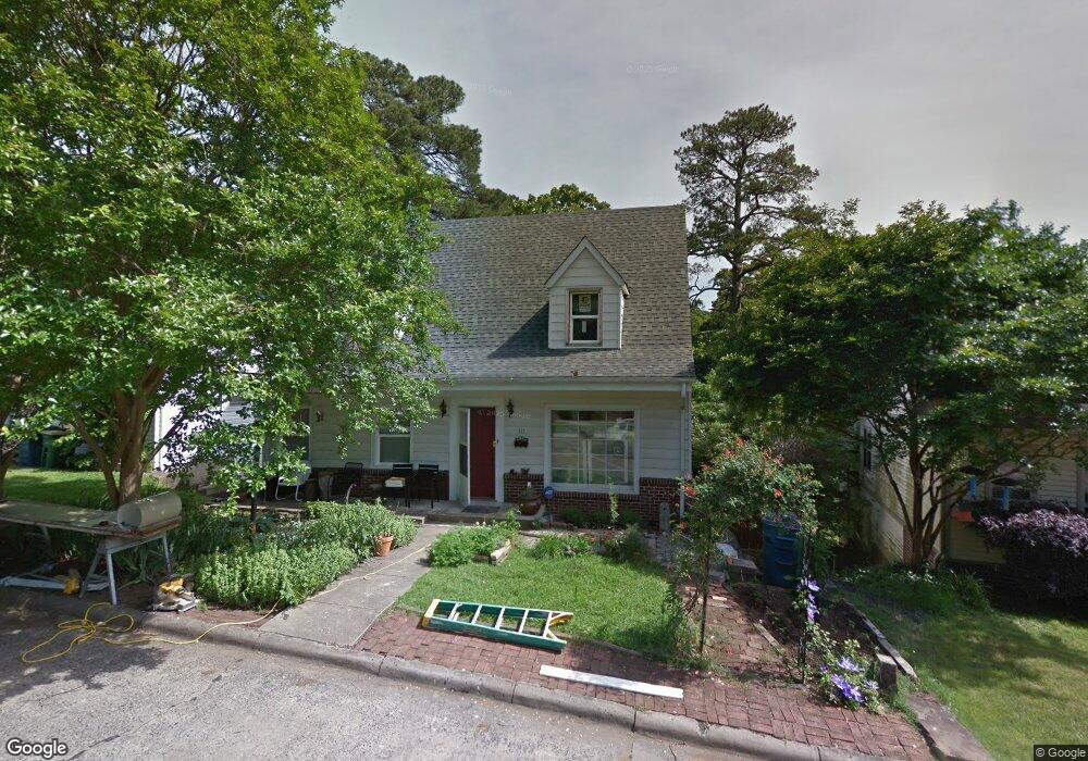
311 Fern Ave Little Rock, AR 72205
Hillcrest NeighborhoodEstimated Value: $334,000 - $489,000
--
Bed
4
Baths
2,992
Sq Ft
$128/Sq Ft
Est. Value
About This Home
This home is located at 311 Fern Ave, Little Rock, AR 72205 and is currently estimated at $382,355, approximately $127 per square foot. 311 Fern Ave is a home located in Pulaski County with nearby schools including M.L. King Elementary School, Dunbar Magnet Middle School, and Central High School.
Ownership History
Date
Name
Owned For
Owner Type
Purchase Details
Closed on
Apr 12, 2023
Sold by
Efird Family Revocable Trust
Bought by
Efired Debra
Current Estimated Value
Purchase Details
Closed on
Oct 24, 2003
Sold by
Velek William Patrick and Veleck Jo Cassidy
Bought by
Efird David and Baldridge Helen
Home Financials for this Owner
Home Financials are based on the most recent Mortgage that was taken out on this home.
Original Mortgage
$161,405
Interest Rate
5.96%
Mortgage Type
Purchase Money Mortgage
Purchase Details
Closed on
Mar 25, 2002
Sold by
Meeker Russell and Meeker Gracie
Bought by
Velek William Patrick and Velek Jo Cassidy
Home Financials for this Owner
Home Financials are based on the most recent Mortgage that was taken out on this home.
Original Mortgage
$144,875
Interest Rate
6.78%
Mortgage Type
Purchase Money Mortgage
Create a Home Valuation Report for This Property
The Home Valuation Report is an in-depth analysis detailing your home's value as well as a comparison with similar homes in the area
Home Values in the Area
Average Home Value in this Area
Purchase History
| Date | Buyer | Sale Price | Title Company |
|---|---|---|---|
| Efired Debra | -- | None Listed On Document | |
| Efird David | $170,000 | -- | |
| Velek William Patrick | $153,000 | Stewart Title |
Source: Public Records
Mortgage History
| Date | Status | Borrower | Loan Amount |
|---|---|---|---|
| Previous Owner | Efird David | $161,405 | |
| Previous Owner | Velek William Patrick | $144,875 |
Source: Public Records
Tax History Compared to Growth
Tax History
| Year | Tax Paid | Tax Assessment Tax Assessment Total Assessment is a certain percentage of the fair market value that is determined by local assessors to be the total taxable value of land and additions on the property. | Land | Improvement |
|---|---|---|---|---|
| 2025 | $3,232 | $61,025 | $4,000 | $57,025 |
| 2024 | $2,963 | $61,025 | $4,000 | $57,025 |
| 2023 | $2,963 | $61,025 | $4,000 | $57,025 |
| 2022 | $2,828 | $61,025 | $4,000 | $57,025 |
| 2021 | $2,713 | $50,800 | $4,400 | $46,400 |
| 2020 | $2,211 | $50,800 | $4,400 | $46,400 |
| 2019 | $2,103 | $50,800 | $4,400 | $46,400 |
| 2018 | $2,021 | $50,800 | $4,400 | $46,400 |
| 2017 | $1,913 | $50,800 | $4,400 | $46,400 |
| 2016 | $1,805 | $44,560 | $6,000 | $38,560 |
| 2015 | $1,899 | $29,555 | $6,000 | $23,555 |
| 2014 | $1,899 | $27,095 | $6,000 | $21,095 |
Source: Public Records
Map
Nearby Homes
- 2717 W Capitol Ave
- 306 S Woodrow St
- 305 Booker St
- 400 S Booker St
- 216 Rice St
- 121 N Woodrow St
- 111 Midland St
- 201 Dennison St
- 312 Barton St
- 102 Midland St
- 3212 Lamar St
- 1116 Kavanaugh Blvd
- 203 Midland St
- 301 N Woodrow St
- 1109 Kavanaugh Blvd
- 1204 Kavanaugh Blvd
- 923 Booker St
- 313 Charles St
- 1004 Johnson St
- 312 Valmar St