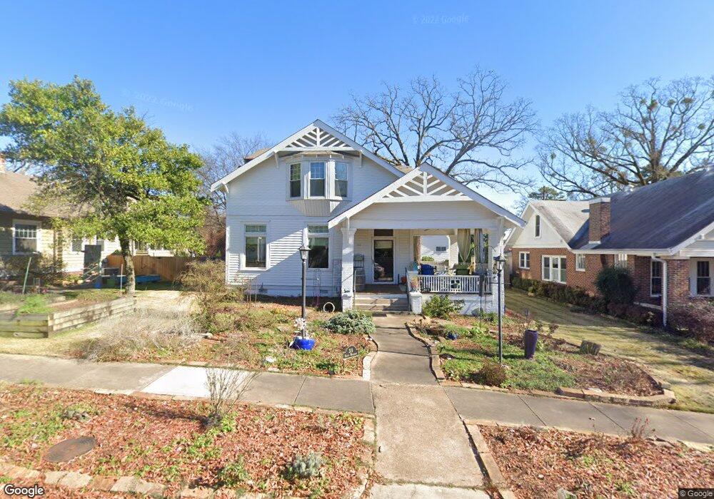
311 N Woodrow St Little Rock, AR 72205
Hillcrest NeighborhoodEstimated Value: $458,000 - $678,669
--
Bed
2
Baths
3,126
Sq Ft
$189/Sq Ft
Est. Value
About This Home
This home is located at 311 N Woodrow St, Little Rock, AR 72205 and is currently estimated at $592,167, approximately $189 per square foot. 311 N Woodrow St is a home located in Pulaski County with nearby schools including Pulaski Heights Elementary School, Pulaski Heights Middle School, and Central High School.
Ownership History
Date
Name
Owned For
Owner Type
Purchase Details
Closed on
Sep 5, 2025
Sold by
Schulz Margaret
Bought by
Margaret A Schulz Family Trust and Schulz
Current Estimated Value
Purchase Details
Closed on
Sep 20, 2002
Sold by
Schulz Eldon G and Schulz Margaret A
Bought by
Schulz Eldon and Schulz Margaret
Home Financials for this Owner
Home Financials are based on the most recent Mortgage that was taken out on this home.
Original Mortgage
$143,000
Interest Rate
6.26%
Purchase Details
Closed on
Aug 23, 2002
Sold by
Granberry Mark Claude and Granberry Kelli Anne
Bought by
Torbett Matthew W and Torbett Shannon R
Home Financials for this Owner
Home Financials are based on the most recent Mortgage that was taken out on this home.
Original Mortgage
$143,000
Interest Rate
6.26%
Create a Home Valuation Report for This Property
The Home Valuation Report is an in-depth analysis detailing your home's value as well as a comparison with similar homes in the area
Home Values in the Area
Average Home Value in this Area
Purchase History
| Date | Buyer | Sale Price | Title Company |
|---|---|---|---|
| Margaret A Schulz Family Trust | -- | None Listed On Document | |
| Schulz Eldon | -- | American Abstract & Title Co | |
| Torbett Matthew W | $245,000 | Lenders Title Co |
Source: Public Records
Mortgage History
| Date | Status | Borrower | Loan Amount |
|---|---|---|---|
| Previous Owner | Schulz Eldon | $143,000 |
Source: Public Records
Tax History Compared to Growth
Tax History
| Year | Tax Paid | Tax Assessment Tax Assessment Total Assessment is a certain percentage of the fair market value that is determined by local assessors to be the total taxable value of land and additions on the property. | Land | Improvement |
|---|---|---|---|---|
| 2025 | $4,261 | $103,191 | $37,500 | $65,691 |
| 2024 | $4,261 | $103,191 | $37,500 | $65,691 |
| 2023 | $4,261 | $103,191 | $37,500 | $65,691 |
| 2022 | $4,261 | $103,191 | $37,500 | $65,691 |
| 2021 | $4,291 | $90,540 | $34,050 | $56,490 |
| 2020 | $3,886 | $90,540 | $34,050 | $56,490 |
| 2019 | $3,886 | $90,540 | $34,050 | $56,490 |
| 2018 | $3,726 | $90,540 | $34,050 | $56,490 |
| 2017 | $3,540 | $90,540 | $34,050 | $56,490 |
| 2016 | $3,355 | $72,130 | $19,950 | $52,180 |
| 2015 | $3,264 | $50,802 | $19,950 | $30,852 |
| 2014 | $3,264 | $46,562 | $19,950 | $26,612 |
Source: Public Records
Map
Nearby Homes
- 1204 Kavanaugh Blvd
- 313 Charles St
- 301 N Woodrow St
- 1116 Kavanaugh Blvd
- 1109 Kavanaugh Blvd
- 121 N Woodrow St
- 203 Midland St
- 111 Midland St
- 102 Midland St
- 306 S Woodrow St
- 305 Booker St
- 505 N Valentine St
- 400 S Booker St
- 3409 Hill Rd
- 206 Linwood Ct
- 312 Valmar St
- 921 Midland St
- 220 S Valentine St
- 2717 W Capitol Ave
- 216 Rice St
- 303 N Woodrow St
- 315 N Woodrow St
- 321 N Woodrow St
- 312 N Woodrow St
- 300 N Woodrow St
- 324 N Woodrow St
- 219 N Woodrow St
- 217 N Woodrow St
- 222 N Woodrow St
- 1212 Kavanaugh Blvd
- 120 Berry St
- 1202 Kavanaugh Blvd
- 124 Berry St
- 116 Berry St
- 116 Berry St Unit N
- 0 Berry S Unit Street
- 116 Berry S Unit St
- 1220 Kavanaugh Blvd
- 112 Berry St Unit 1
- 2909 Little St