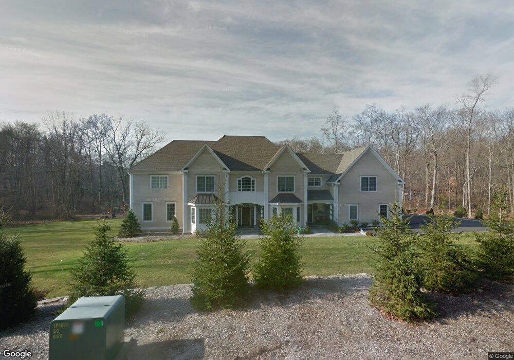
311 Weed St New Canaan, CT 06840
Estimated Value: $3,756,000 - $3,989,584
4
Beds
6
Baths
5,508
Sq Ft
$707/Sq Ft
Est. Value
About This Home
This home is located at 311 Weed St, New Canaan, CT 06840 and is currently estimated at $3,892,396, approximately $706 per square foot. 311 Weed St is a home located in Fairfield County with nearby schools including South Elementary School, Saxe Middle School, and New Canaan High School.
Ownership History
Date
Name
Owned For
Owner Type
Purchase Details
Closed on
Jun 18, 2025
Sold by
Paschalidis Haramlambos L
Bought by
Paschalidis Irene
Current Estimated Value
Purchase Details
Closed on
Jan 13, 2014
Sold by
Garfunkel Kenneth
Bought by
1551 Dixwell Llc
Purchase Details
Closed on
Jun 17, 2010
Sold by
Bank Of America Na
Bought by
Paschalidis Robert
Purchase Details
Closed on
Feb 3, 2010
Sold by
Brain David H
Bought by
Washington Mutual Bk
Purchase Details
Closed on
Dec 30, 2003
Sold by
Lilyan F Koff Rt and Successor W
Bought by
Brain David H and Brain Cecilia V
Create a Home Valuation Report for This Property
The Home Valuation Report is an in-depth analysis detailing your home's value as well as a comparison with similar homes in the area
Home Values in the Area
Average Home Value in this Area
Purchase History
| Date | Buyer | Sale Price | Title Company |
|---|---|---|---|
| Paschalidis Irene | -- | -- | |
| 1551 Dixwell Llc | $354,000 | -- | |
| Paschalidis Robert | $580,001 | -- | |
| Washington Mutual Bk | -- | -- | |
| Brain David H | $775,000 | -- |
Source: Public Records
Mortgage History
| Date | Status | Borrower | Loan Amount |
|---|---|---|---|
| Previous Owner | Brain David H | $920,000 | |
| Previous Owner | Brain David H | $115,000 | |
| Previous Owner | Brain David H | $997,500 |
Source: Public Records
Tax History Compared to Growth
Tax History
| Year | Tax Paid | Tax Assessment Tax Assessment Total Assessment is a certain percentage of the fair market value that is determined by local assessors to be the total taxable value of land and additions on the property. | Land | Improvement |
|---|---|---|---|---|
| 2025 | $35,529 | $2,128,770 | $870,100 | $1,258,670 |
| 2024 | $34,358 | $2,128,770 | $870,100 | $1,258,670 |
| 2023 | $29,654 | $1,565,690 | $801,150 | $764,540 |
| 2022 | $28,762 | $1,565,690 | $801,150 | $764,540 |
| 2021 | $28,433 | $1,565,690 | $801,150 | $764,540 |
| 2020 | $28,433 | $1,565,690 | $801,150 | $764,540 |
| 2019 | $28,558 | $1,565,690 | $801,150 | $764,540 |
| 2018 | $26,147 | $1,541,680 | $636,790 | $904,890 |
| 2017 | $25,700 | $1,541,680 | $636,790 | $904,890 |
| 2016 | $25,145 | $1,541,680 | $636,790 | $904,890 |
| 2015 | $24,651 | $1,541,680 | $636,790 | $904,890 |
| 2014 | $23,958 | $1,541,680 | $636,790 | $904,890 |
Source: Public Records
Map
Nearby Homes
- 202 Weed St
- 317 Park St
- 25 Gower Rd
- 354 South Ave
- 470 Frogtown Rd Unit Lot 1
- 100 Spring Water Ln
- 197 Park St Unit 13
- 139 Jelliff Mill Rd
- 50 Harrison Ave
- 357 Jelliff Mill Rd
- 31 Selleck Place
- 474 Ponus Ridge
- 15 Burtis Ave Unit Townhome D
- 15 Burtis Ave Unit West Penthouse B
- 15 Burtis Ave Unit East Penthouse C
- 15 Burtis Ave Unit Townhome A
- 15 Burtis Ave Unit East Plaza 203
- 52 Putnam Rd
- 44 Putnam Rd
- 180 Summer St