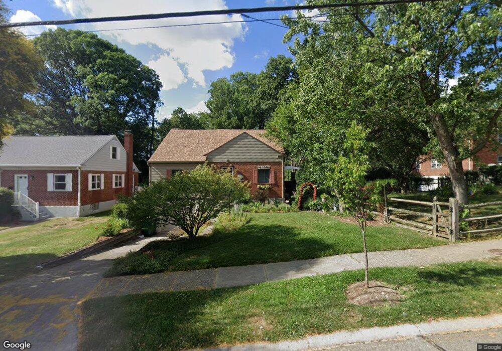
3112 West Tower Ave Cincinnati, OH 45238
Westwood NeighborhoodEstimated Value: $185,616 - $197,000
2
Beds
1
Bath
1,542
Sq Ft
$123/Sq Ft
Est. Value
About This Home
This home is located at 3112 West Tower Ave, Cincinnati, OH 45238 and is currently estimated at $189,904, approximately $123 per square foot. 3112 West Tower Ave is a home located in Hamilton County with nearby schools including Midway Elementary School, Western Hills High School, and Gilbert A. Dater High School.
Ownership History
Date
Name
Owned For
Owner Type
Purchase Details
Closed on
Jun 22, 1998
Sold by
Schmitt Douglas J and Ellert Schmitt Kathleen
Bought by
Burgasser Kathleen M
Current Estimated Value
Home Financials for this Owner
Home Financials are based on the most recent Mortgage that was taken out on this home.
Original Mortgage
$74,950
Outstanding Balance
$13,587
Interest Rate
7.27%
Estimated Equity
$176,317
Create a Home Valuation Report for This Property
The Home Valuation Report is an in-depth analysis detailing your home's value as well as a comparison with similar homes in the area
Home Values in the Area
Average Home Value in this Area
Purchase History
| Date | Buyer | Sale Price | Title Company |
|---|---|---|---|
| Burgasser Kathleen M | $78,900 | Multi-State Title Agency |
Source: Public Records
Mortgage History
| Date | Status | Borrower | Loan Amount |
|---|---|---|---|
| Open | Burgasser Kathleen M | $74,950 |
Source: Public Records
Tax History
| Year | Tax Paid | Tax Assessment Tax Assessment Total Assessment is a certain percentage of the fair market value that is determined by local assessors to be the total taxable value of land and additions on the property. | Land | Improvement |
|---|---|---|---|---|
| 2025 | $3,064 | $49,634 | $6,542 | $43,092 |
| 2024 | $2,972 | $49,634 | $6,542 | $43,092 |
| 2023 | $3,038 | $49,634 | $6,542 | $43,092 |
| 2022 | $1,723 | $26,194 | $5,313 | $20,881 |
| 2021 | $1,774 | $26,194 | $5,313 | $20,881 |
| 2020 | $1,774 | $26,194 | $5,313 | $20,881 |
| 2019 | $1,763 | $23,814 | $4,830 | $18,984 |
| 2018 | $1,766 | $23,814 | $4,830 | $18,984 |
| 2017 | $1,677 | $23,814 | $4,830 | $18,984 |
| 2016 | $1,993 | $27,923 | $5,607 | $22,316 |
| 2015 | $1,798 | $27,923 | $5,607 | $22,316 |
| 2014 | $1,811 | $27,923 | $5,607 | $22,316 |
| 2013 | $1,918 | $29,089 | $5,842 | $23,247 |
Source: Public Records
Map
Nearby Homes
- 3124 Veazey Ave
- 3141 W Tower Ave
- 3061 Veazey Ave
- 2925 Boudinot Ave
- 3011 Westbrook Dr
- 3305 Queen City Ave
- 3004 Glenmore Ave
- 3106 Werk Rd
- 5020 Sidney Rd
- 3373 Kathy Ln
- 3101 Ramona Ave
- 4915 Heuwerth Ave
- 2640 Gehrum Ln
- 2195 Woodmere Ct
- 4778 Prosperity Place
- 1650 Colonial Dr
- 4740 Green Glen Ln
- 3059 Lischer Ave
- 5132 Ralph Ave
- 1877 Ashbrook Dr
- 3116 West Tower Ave
- 3120 W Tower Ave
- 3120 West Tower Ave
- 3104 West Tower Ave
- 2515 Boudinot Ave
- 3124 W Tower Ave
- 3124 West Tower Ave
- 3115 West Tower Ave
- 3115 W Tower Ave
- 3117 West Tower Ave
- 3117 W Tower Ave
- 2495 Boudinot Ave
- 3128 W Tower Ave
- 3121 West Tower Ave
- 3121 W Tower Ave
- 3128 West Tower Ave
- 2473 Boudinot Ave
- 3125 West Tower Ave
- 3132 W Tower Ave
- 3132 West Tower Ave
Your Personal Tour Guide
Ask me questions while you tour the home.