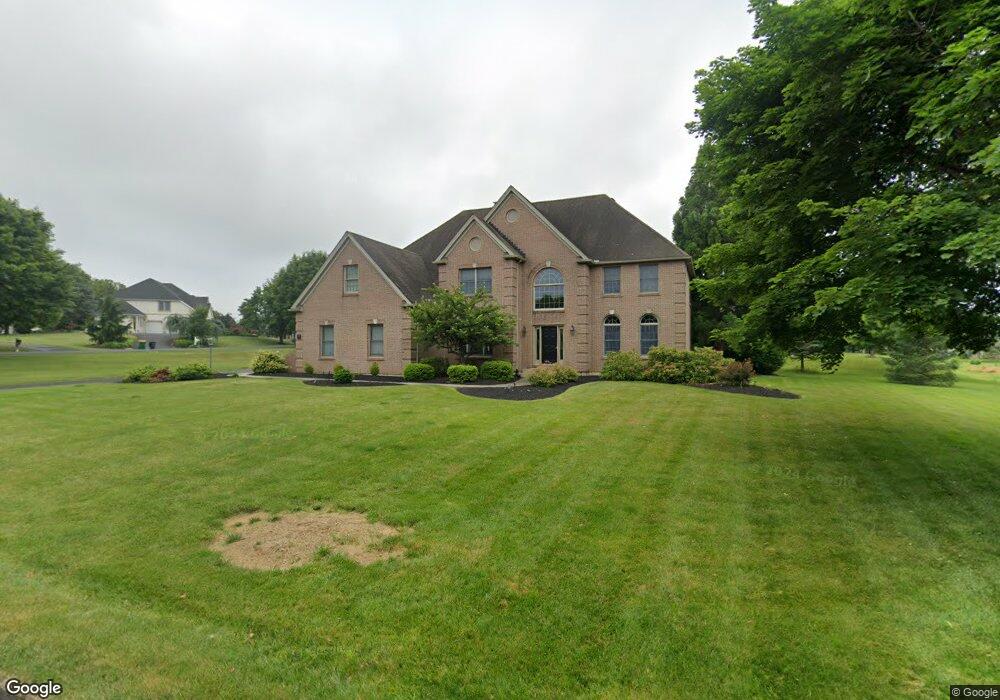
3116 Bradford Cir Emmaus, PA 18049
Lower Macungie Township East NeighborhoodEstimated Value: $759,000 - $941,000
4
Beds
4
Baths
3,645
Sq Ft
$227/Sq Ft
Est. Value
About This Home
This home is located at 3116 Bradford Cir, Emmaus, PA 18049 and is currently estimated at $828,932, approximately $227 per square foot. 3116 Bradford Cir is a home located in Lehigh County with nearby schools including Macungie Elementary School, Eyer Middle School, and Emmaus High School.
Ownership History
Date
Name
Owned For
Owner Type
Purchase Details
Closed on
Jul 17, 1997
Sold by
Brookhaven Development Corp
Bought by
Marsh Eric J and Pisano Michele A
Current Estimated Value
Purchase Details
Closed on
Aug 15, 1991
Bought by
Brookhaven Development Corporation
Purchase Details
Closed on
Sep 1, 1988
Sold by
Brookhaven Development Corp
Bought by
Wilkinson Wilkinson E and Wilkinson Carol M
Purchase Details
Closed on
Dec 31, 1985
Bought by
Brookhaven Development Corp
Create a Home Valuation Report for This Property
The Home Valuation Report is an in-depth analysis detailing your home's value as well as a comparison with similar homes in the area
Home Values in the Area
Average Home Value in this Area
Purchase History
| Date | Buyer | Sale Price | Title Company |
|---|---|---|---|
| Marsh Eric J | $80,000 | -- | |
| Brookhaven Development Corporation | $59,000 | -- | |
| Wilkinson Wilkinson E | $59,900 | -- | |
| Brookhaven Development Corp | $354,900 | -- |
Source: Public Records
Tax History Compared to Growth
Tax History
| Year | Tax Paid | Tax Assessment Tax Assessment Total Assessment is a certain percentage of the fair market value that is determined by local assessors to be the total taxable value of land and additions on the property. | Land | Improvement |
|---|---|---|---|---|
| 2025 | $13,692 | $536,300 | $59,300 | $477,000 |
| 2024 | $13,247 | $536,300 | $59,300 | $477,000 |
| 2023 | $12,982 | $536,300 | $59,300 | $477,000 |
| 2022 | $12,675 | $536,300 | $477,000 | $59,300 |
| 2021 | $12,405 | $536,300 | $59,300 | $477,000 |
| 2020 | $12,287 | $536,300 | $59,300 | $477,000 |
| 2019 | $12,078 | $536,300 | $59,300 | $477,000 |
| 2018 | $11,919 | $536,300 | $59,300 | $477,000 |
| 2017 | $11,711 | $536,300 | $59,300 | $477,000 |
| 2016 | -- | $536,300 | $59,300 | $477,000 |
| 2015 | -- | $536,300 | $59,300 | $477,000 |
| 2014 | -- | $536,300 | $59,300 | $477,000 |
Source: Public Records
Map
Nearby Homes
- 3149 Sheffield Dr
- 3045 Sheffield Dr
- 4490 Canterbury Dr
- 4804 Parkview Dr S
- 2834 Sheffield Dr
- 4476 Stonebridge Dr
- 3721 Samantha Ln
- 3721 Samantha Ln Unit 76
- 3703 Samantha Ln Unit Lot 70
- 3736 Samantha Ln Unit Lot 7
- 3748 Samantha Ln
- 3748 Samantha Ln Unit Lot 3
- 3734 Samantha Ln Unit Lot 8
- 3746 Samantha Ln Unit Lot 4
- 3713 Samantha Ln Unit Lot 73
- 3707 Samantha Ln Unit Lot 71
- 2570 Millbrook Dr
- Foxgrove I - TR Plan at The Fields at Twin Run
- Folcroft -TR Plan at The Fields at Twin Run
- Sierra - TR Plan at The Fields at Twin Run
- 4545 Woodlawn Dr
- 3113 Bradford Cir
- 3134 Bradford Cir
- 4569 Woodlawn Dr
- 4591 Commonwealth Dr
- 4524 Woodlawn Dr
- 4541 Woodlawn Dr
- 3131 Bradford Cir
- 4502 Woodlawn Dr
- 4481 Woodlawn Dr
- 4588 Belmont Dr
- 4603 Commonwealth Dr
- 4572 Belmont Dr
- 4519 Commonwealth Dr
- 4604 Belmont Dr
- 3106 Sheffield Dr
- 4560 Belmont Dr
- 3126 Sheffield Dr
- 4412 Commonwealth Dr
- 4368 Commonwealth Dr