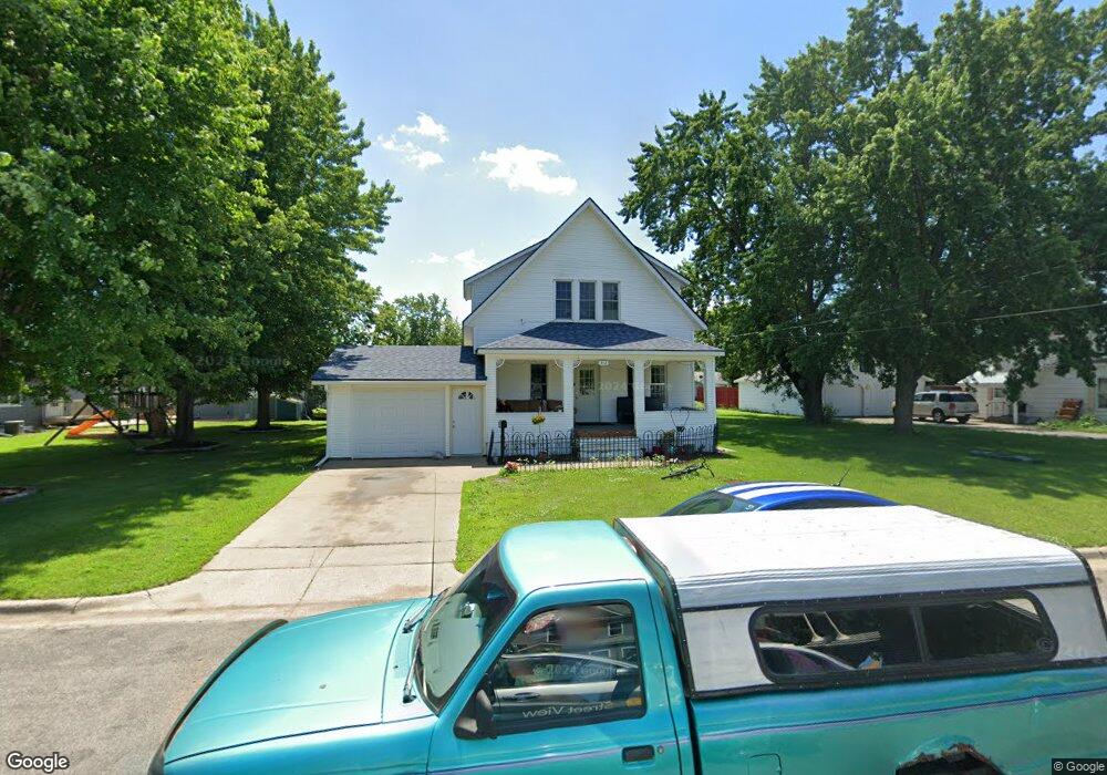
312 1st St SW Melrose, MN 56352
Estimated Value: $183,000 - $215,961
3
Beds
1
Bath
1,424
Sq Ft
$136/Sq Ft
Est. Value
About This Home
This home is located at 312 1st St SW, Melrose, MN 56352 and is currently estimated at $194,240, approximately $136 per square foot. 312 1st St SW is a home located in Stearns County with nearby schools including Melrose Elementary School, Melrose Middle School, and Melrose Secondary School.
Ownership History
Date
Name
Owned For
Owner Type
Purchase Details
Closed on
Feb 4, 2011
Sold by
Federal Home Loan Mortgage Corporation
Bought by
Housman Nathan John
Current Estimated Value
Purchase Details
Closed on
May 3, 2004
Sold by
Zink Matthew
Bought by
Haverkamp Paul
Purchase Details
Closed on
Oct 12, 2000
Sold by
Melrose Credit Union
Bought by
Zink Matthew
Purchase Details
Closed on
Sep 26, 2000
Sold by
Ogle Ricky
Bought by
Melrose Credit Union
Purchase Details
Closed on
Dec 24, 1996
Sold by
Melrose Credit Union
Bought by
Ogle
Create a Home Valuation Report for This Property
The Home Valuation Report is an in-depth analysis detailing your home's value as well as a comparison with similar homes in the area
Home Values in the Area
Average Home Value in this Area
Purchase History
| Date | Buyer | Sale Price | Title Company |
|---|---|---|---|
| Housman Nathan John | $56,900 | -- | |
| Haverkamp Paul | $100,000 | -- | |
| Zink Matthew | $50,000 | -- | |
| Melrose Credit Union | $5,000 | -- | |
| Ogle | -- | -- |
Source: Public Records
Tax History Compared to Growth
Tax History
| Year | Tax Paid | Tax Assessment Tax Assessment Total Assessment is a certain percentage of the fair market value that is determined by local assessors to be the total taxable value of land and additions on the property. | Land | Improvement |
|---|---|---|---|---|
| 2025 | $1,852 | $185,800 | $25,100 | $160,700 |
| 2024 | $1,618 | $166,300 | $20,900 | $145,400 |
| 2023 | $1,574 | $146,200 | $17,700 | $128,500 |
| 2022 | $1,466 | $113,100 | $17,700 | $95,400 |
| 2021 | $1,510 | $113,100 | $17,700 | $95,400 |
| 2020 | $1,544 | $107,100 | $17,700 | $89,400 |
| 2019 | $1,498 | $107,100 | $17,700 | $89,400 |
| 2018 | $1,070 | $92,600 | $17,700 | $74,900 |
| 2017 | $976 | $86,700 | $17,700 | $69,000 |
| 2016 | $942 | $0 | $0 | $0 |
| 2015 | $948 | $0 | $0 | $0 |
| 2014 | -- | $0 | $0 | $0 |
Source: Public Records
Map
Nearby Homes
- TBD Kraft Dr
- 320 2nd Ave SW
- 410 2nd St NW
- 100 Rose Park
- 113 4th St SW
- 76 Rose Park
- TBD County Road 170
- 523 5th Ave SE
- 129 Meadowlark Ln SW
- 241 Meadowlark Ln SW
- 312 Highland Blvd
- 324 Highland Blvd
- 206 Highland Blvd
- 210 Highland Blvd
- 304 Highland Blvd
- 242 3rd Ave W
- 272 3rd Ave W
- 232 3rd Ave W
- 282 3rd Ave W
- 252 3rd Ave W
- 312 1st St SW
- 312 1st St SW
- 312 1st St SW
- 304 1st St SW
- 322 1st St SW
- 311 1st St SW
- 19 3rd Ave SW
- 319 1st St SW
- 326 1st St SW
- 117 3rd Ave SW
- 309 Second St SW
- 309 309 W 2nd-Street-s
- 309 309 W 2nd St S
- 226 1st St SW
- 315 315 W 2nd St S
- 20 4th Ave SW
- 325 2nd St SW
- 222 1st St SW
- 321 2nd St SW
- 325 2nd St SW