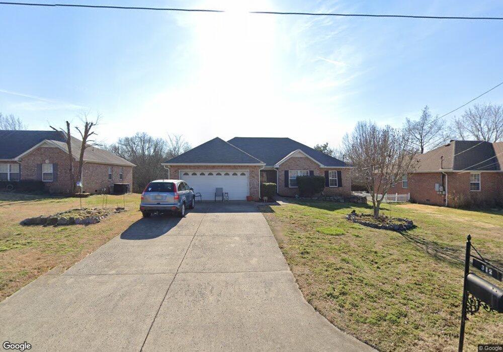
312 Acorn Ct Smyrna, TN 37167
Estimated Value: $339,544 - $390,000
--
Bed
3
Baths
1,456
Sq Ft
$254/Sq Ft
Est. Value
About This Home
This home is located at 312 Acorn Ct, Smyrna, TN 37167 and is currently estimated at $370,136, approximately $254 per square foot. 312 Acorn Ct is a home located in Rutherford County with nearby schools including Rocky Fork Elementary School, Rocky Fork Middle School, and Smyrna High School.
Ownership History
Date
Name
Owned For
Owner Type
Purchase Details
Closed on
Jan 15, 2025
Sold by
Anglea Tonya Helena
Bought by
312 Acorn Ct Land Trust and Trustee Inc
Current Estimated Value
Purchase Details
Closed on
Nov 20, 2003
Sold by
Doran Edwin E
Bought by
Doran Edwin E
Purchase Details
Closed on
Apr 14, 1999
Sold by
Keystone Homes Llc
Bought by
Doran Edwin E and Doran Lavera M
Home Financials for this Owner
Home Financials are based on the most recent Mortgage that was taken out on this home.
Original Mortgage
$101,500
Interest Rate
7.13%
Create a Home Valuation Report for This Property
The Home Valuation Report is an in-depth analysis detailing your home's value as well as a comparison with similar homes in the area
Home Values in the Area
Average Home Value in this Area
Purchase History
| Date | Buyer | Sale Price | Title Company |
|---|---|---|---|
| 312 Acorn Ct Land Trust | -- | None Listed On Document | |
| 312 Acorn Ct Land Trust | -- | None Listed On Document | |
| Doran Edwin E | -- | -- | |
| Doran Edwin E | $126,900 | -- |
Source: Public Records
Mortgage History
| Date | Status | Borrower | Loan Amount |
|---|---|---|---|
| Previous Owner | Doran Edwin E | $101,500 |
Source: Public Records
Tax History Compared to Growth
Tax History
| Year | Tax Paid | Tax Assessment Tax Assessment Total Assessment is a certain percentage of the fair market value that is determined by local assessors to be the total taxable value of land and additions on the property. | Land | Improvement |
|---|---|---|---|---|
| 2025 | $1,828 | $76,125 | $13,750 | $62,375 |
| 2024 | $1,828 | $76,125 | $13,750 | $62,375 |
| 2023 | $1,721 | $71,650 | $13,750 | $57,900 |
| 2022 | $1,535 | $71,650 | $13,750 | $57,900 |
| 2021 | $1,438 | $49,250 | $10,000 | $39,250 |
| 2020 | $1,438 | $49,250 | $10,000 | $39,250 |
| 2019 | $1,438 | $49,250 | $10,000 | $39,250 |
| 2018 | $1,379 | $49,250 | $0 | $0 |
| 2017 | $1,270 | $35,650 | $0 | $0 |
| 2016 | $1,270 | $35,650 | $0 | $0 |
| 2015 | $1,270 | $35,650 | $0 | $0 |
| 2014 | $887 | $35,650 | $0 | $0 |
| 2013 | -- | $36,675 | $0 | $0 |
Source: Public Records
Map
Nearby Homes
- 119 Tedder Blvd
- 131 Tedder Blvd
- 412 Gooding Blvd
- 508 Restoration Dr
- 107 Oak Valley Cir
- 512 D Ann Dr
- 148 Tedder Blvd
- 120 Ace Ave
- 130 Ace Ave
- 140 Ace Ave
- 110 Ace Ave
- 445 Slugger St
- 437 Slugger St
- 453 Slugger St
- 441 Slugger St
- 3040 Denny Brooke Ln
- 3011 Denny Brooke Ln
- 1307 Talia Trace Plan at Talia Trace
- 1781-3 Talia Trace Town Home Plan at Talia Trace
- 1723-2 Talia Trace Town Home Plan at Talia Trace