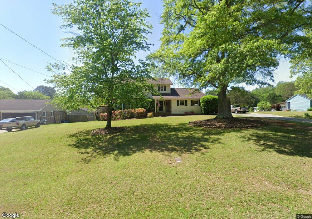
312 Birdie Rd Griffin, GA 30223
Spalding County NeighborhoodEstimated Value: $236,000 - $317,000
4
Beds
3
Baths
2,436
Sq Ft
$112/Sq Ft
Est. Value
About This Home
This home is located at 312 Birdie Rd, Griffin, GA 30223 and is currently estimated at $272,647, approximately $111 per square foot. 312 Birdie Rd is a home located in Spalding County with nearby schools including Beaverbrook Elementary School, Cowan Road Middle School, and Griffin High School.
Ownership History
Date
Name
Owned For
Owner Type
Purchase Details
Closed on
Nov 3, 2024
Sold by
Negris Daniel Gene
Bought by
Negris Nancy Houser
Current Estimated Value
Purchase Details
Closed on
Nov 29, 1989
Sold by
Self Robert A and Self Alice
Bought by
Negris Daniel G and Negris Nancy H
Purchase Details
Closed on
Aug 28, 1975
Sold by
Wilson E D
Bought by
Self Robert A and Self Alice
Purchase Details
Closed on
Sep 14, 1973
Sold by
West Griffin Congregational Holiness Ch
Bought by
Wilson E D
Purchase Details
Closed on
Aug 25, 1972
Sold by
Collier Collier J and Collier Hill M
Bought by
West Griffin Congregational Holiness Ch
Create a Home Valuation Report for This Property
The Home Valuation Report is an in-depth analysis detailing your home's value as well as a comparison with similar homes in the area
Home Values in the Area
Average Home Value in this Area
Purchase History
| Date | Buyer | Sale Price | Title Company |
|---|---|---|---|
| Negris Nancy Houser | -- | -- | |
| Negris Daniel G | $93,000 | -- | |
| Self Robert A | $6,000 | -- | |
| Wilson E D | $5,000 | -- | |
| West Griffin Congregational Holiness Ch | $4,500 | -- |
Source: Public Records
Tax History Compared to Growth
Tax History
| Year | Tax Paid | Tax Assessment Tax Assessment Total Assessment is a certain percentage of the fair market value that is determined by local assessors to be the total taxable value of land and additions on the property. | Land | Improvement |
|---|---|---|---|---|
| 2024 | $1,668 | $65,819 | $5,821 | $59,998 |
| 2023 | $1,668 | $60,572 | $5,821 | $54,751 |
| 2022 | $1,910 | $52,521 | $5,390 | $47,131 |
| 2021 | $1,351 | $47,968 | $5,390 | $42,578 |
| 2020 | $1,357 | $47,968 | $5,390 | $42,578 |
| 2019 | $1,384 | $47,968 | $5,390 | $42,578 |
| 2018 | $1,340 | $44,112 | $5,390 | $38,722 |
| 2017 | $1,304 | $44,112 | $5,390 | $38,722 |
| 2016 | $1,327 | $44,112 | $5,390 | $38,722 |
| 2015 | $1,369 | $44,112 | $5,390 | $38,722 |
| 2014 | $1,682 | $44,112 | $5,390 | $38,722 |
Source: Public Records
Map
Nearby Homes
- 114 Woodcrest Dr
- 230 Manley Rd
- 1060 Patterson Rd
- 1100 Patterson Rd
- 1120 Patterson Rd
- 130 N Morgan Dr
- 111 Patterson Rd
- 1980 Kilgore Rd
- 225 School Rd
- 78 Helen Dr
- 117 Teamon Rd
- 0 Elder Rd Unit 25075151
- 0 Elder Rd Unit 10619475
- 111 Vineyard Rd
- 5061 Old Atlanta Rd
- 1690 Patterson Rd
- 813 Vineyard Rd
- 2407 Old Atlanta Rd
- 205 Westmoreland Dr
- 208 Tyler Trace