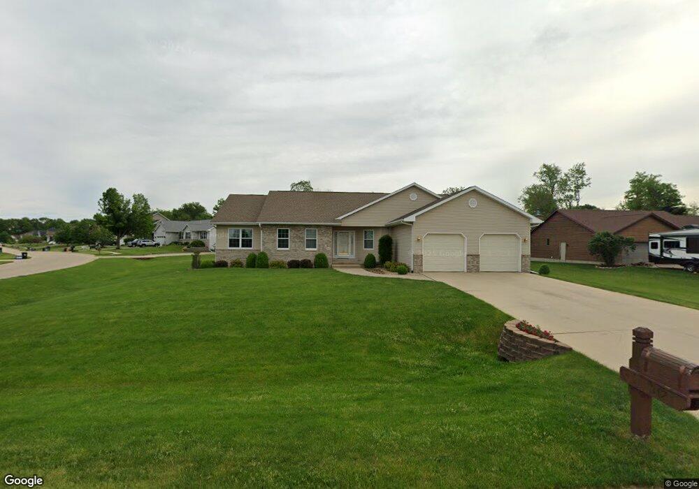
312 Brougham Ct Robins, IA 52328
Estimated Value: $515,885 - $625,000
3
Beds
3
Baths
2,656
Sq Ft
$217/Sq Ft
Est. Value
About This Home
This home is located at 312 Brougham Ct, Robins, IA 52328 and is currently estimated at $575,971, approximately $216 per square foot. 312 Brougham Ct is a home located in Linn County with nearby schools including Echo Hill Elementary School, Oak Ridge School, and Linn-Mar High School.
Ownership History
Date
Name
Owned For
Owner Type
Purchase Details
Closed on
Oct 21, 2006
Sold by
Edwards James O and Edwards Barbara A
Bought by
Frerking Marvin E and Frerking Shirley H
Current Estimated Value
Home Financials for this Owner
Home Financials are based on the most recent Mortgage that was taken out on this home.
Original Mortgage
$284,000
Outstanding Balance
$169,375
Interest Rate
6.45%
Mortgage Type
Purchase Money Mortgage
Estimated Equity
$406,596
Create a Home Valuation Report for This Property
The Home Valuation Report is an in-depth analysis detailing your home's value as well as a comparison with similar homes in the area
Home Values in the Area
Average Home Value in this Area
Purchase History
| Date | Buyer | Sale Price | Title Company |
|---|---|---|---|
| Frerking Marvin E | $354,500 | None Available |
Source: Public Records
Mortgage History
| Date | Status | Borrower | Loan Amount |
|---|---|---|---|
| Open | Frerking Marvin E | $284,000 |
Source: Public Records
Tax History Compared to Growth
Tax History
| Year | Tax Paid | Tax Assessment Tax Assessment Total Assessment is a certain percentage of the fair market value that is determined by local assessors to be the total taxable value of land and additions on the property. | Land | Improvement |
|---|---|---|---|---|
| 2025 | $7,458 | $600,800 | $62,600 | $538,200 |
| 2024 | $6,622 | $502,000 | $62,600 | $439,400 |
| 2023 | $6,622 | $502,000 | $62,600 | $439,400 |
| 2022 | $6,872 | $398,300 | $62,600 | $335,700 |
| 2021 | $6,926 | $398,300 | $62,600 | $335,700 |
| 2020 | $6,926 | $374,900 | $62,600 | $312,300 |
| 2019 | $6,992 | $379,400 | $62,600 | $316,800 |
| 2018 | $6,740 | $379,400 | $62,600 | $316,800 |
| 2017 | $6,624 | $361,500 | $62,600 | $298,900 |
| 2016 | $6,624 | $361,500 | $62,600 | $298,900 |
| 2015 | $6,642 | $361,500 | $62,600 | $298,900 |
| 2014 | $6,482 | $361,500 | $62,600 | $298,900 |
| 2013 | $6,244 | $361,500 | $62,600 | $298,900 |
Source: Public Records
Map
Nearby Homes
- 0 Maple St
- 545 Evergreen Ln
- 9014 Grand Oaks Dr NE
- 9124 Grand Oaks Dr NE
- 8926 Norway Dr NE
- 8809 Middlebury Ct NE
- 8908 Norway Dr NE
- 1332 Stratton Dr NE
- 165 Timber Ln
- 70.78 Acres M L Quass Rd
- 923 Messina Dr NE
- 929 Messina Dr NE
- 8201 Council St NE
- 207 Meadows Field Dr NE
- 219 Meadows Field Dr NE
- 222 Mccarran Ave NE
- 226 Mccarran Ave NE
- 8901 Zeppelin Ave NE
- 8139 Turtlerun Dr NE
- 219 Mccarran Ave NE
- 314 Brougham Ct
- 330 Brougham Rd
- 325 Brougham Rd
- 445 Cypress Ct
- 350 Brougham Rd
- 335 Brougham Rd
- 315 Brougham Rd
- 307 Brougham Ct
- 316 Brougham Ct
- 355 Brougham Rd
- 309 Brougham Ct
- 370 Brougham Rd
- 305 Brougham Rd
- 440 Cypress Ct
- 455 Cypress Ct
- 375 Brougham Rd
- 230 Brougham Rd
- 320 Phaeton Dr
- 330 Phaeton Dr
- 390 Brougham Rd