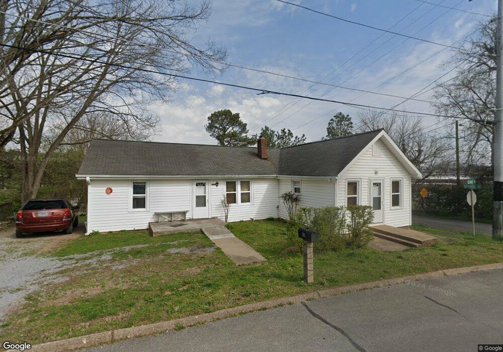
312 Ceaser St Athens, TN 37303
Estimated Value: $168,901 - $244,000
3
Beds
1
Bath
1,408
Sq Ft
$149/Sq Ft
Est. Value
About This Home
This home is located at 312 Ceaser St, Athens, TN 37303 and is currently estimated at $209,225, approximately $148 per square foot. 312 Ceaser St is a home located in McMinn County with nearby schools including Ingleside Elementary School, City Park Elementary School, and Westside Elementary School.
Ownership History
Date
Name
Owned For
Owner Type
Purchase Details
Closed on
Feb 10, 2003
Sold by
Levesque Karrey L
Bought by
Levesque Mark E
Current Estimated Value
Purchase Details
Closed on
Feb 16, 1999
Sold by
Barney Christopher T
Bought by
Levesque Mark E
Home Financials for this Owner
Home Financials are based on the most recent Mortgage that was taken out on this home.
Original Mortgage
$30,000
Interest Rate
6.84%
Purchase Details
Closed on
Aug 18, 1989
Bought by
Barney Christopher T
Purchase Details
Closed on
Jan 1, 1981
Create a Home Valuation Report for This Property
The Home Valuation Report is an in-depth analysis detailing your home's value as well as a comparison with similar homes in the area
Home Values in the Area
Average Home Value in this Area
Purchase History
| Date | Buyer | Sale Price | Title Company |
|---|---|---|---|
| Levesque Mark E | -- | -- | |
| Levesque Mark E | $32,000 | -- | |
| Barney Christopher T | $23,000 | -- | |
| -- | $19,000 | -- |
Source: Public Records
Mortgage History
| Date | Status | Borrower | Loan Amount |
|---|---|---|---|
| Previous Owner | Not Available | $30,000 |
Source: Public Records
Tax History Compared to Growth
Tax History
| Year | Tax Paid | Tax Assessment Tax Assessment Total Assessment is a certain percentage of the fair market value that is determined by local assessors to be the total taxable value of land and additions on the property. | Land | Improvement |
|---|---|---|---|---|
| 2025 | $399 | $19,100 | $0 | $0 |
| 2024 | $399 | $19,100 | $1,775 | $17,325 |
| 2023 | $399 | $19,100 | $1,775 | $17,325 |
| 2022 | $369 | $12,750 | $2,275 | $10,475 |
| 2021 | $369 | $12,750 | $2,275 | $10,475 |
| 2020 | $359 | $12,750 | $2,275 | $10,475 |
| 2019 | $515 | $18,300 | $3,250 | $15,050 |
| 2018 | $515 | $18,300 | $3,250 | $15,050 |
| 2017 | $334 | $11,200 | $1,675 | $9,525 |
| 2016 | $334 | $11,200 | $1,675 | $9,525 |
| 2015 | -- | $11,200 | $1,675 | $9,525 |
| 2014 | $307 | $11,182 | $0 | $0 |
Source: Public Records
Map
Nearby Homes
- 409 High St
- 112 Ray St
- 215 Sunset Dr
- 501 Central Ave
- 530 Sunset Dr
- 421 Hicks St
- 112 S Hill St
- 922 Highway 39 E
- 0 Kilgore St
- 129 Elizabeth St Unit 131
- 110 S Kilgore St
- 106 S Kilgore St
- 215 Forrest Ave
- 13 Douglas St
- 307 W College St
- 118 Highland Ave
- 0 W College St Unit RTC2883680
- 0 W College St Unit 20252139
- 0 W College St Unit 1300814
- 414 Guille St
- 312 Ceasar St
- 215 Ceasar St
- 313 Spring St
- 313 Spring St Unit 313 Spring Street
- 311 Spring St
- 401 High St
- 309 Spring St
- 306 Ceasar St
- 306 Ceaser St
- 405 High St
- 306 Central Ave
- 111 Ray St
- 212 Central Ave
- 115 Ray St
- 113 Ray St
- 210 Central Ave
- 206 Central Ave
- 207 Ceaser St
- 311 Sunset Dr Unit 11
- 501 High St