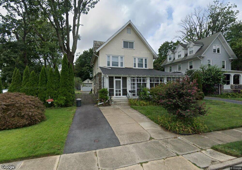
312 Davis Rd Havertown, PA 19083
Estimated Value: $617,000 - $759,000
5
Beds
3
Baths
2,738
Sq Ft
$260/Sq Ft
Est. Value
About This Home
This home is located at 312 Davis Rd, Havertown, PA 19083 and is currently estimated at $710,595, approximately $259 per square foot. 312 Davis Rd is a home located in Delaware County with nearby schools including Chatham Park Elementary School, Haverford Middle School, and Haverford Senior High School.
Ownership History
Date
Name
Owned For
Owner Type
Purchase Details
Closed on
Oct 18, 1991
Sold by
Dages Robert and Dages Phyllis
Bought by
Miller Brad D and Miller Aimee B
Current Estimated Value
Home Financials for this Owner
Home Financials are based on the most recent Mortgage that was taken out on this home.
Original Mortgage
$25,000
Interest Rate
7.08%
Mortgage Type
Purchase Money Mortgage
Purchase Details
Closed on
Oct 15, 1991
Sold by
Dages Robert W and Dages Phyliss D
Bought by
Miller Brad D and Miller Aimee B
Home Financials for this Owner
Home Financials are based on the most recent Mortgage that was taken out on this home.
Original Mortgage
$25,000
Interest Rate
7.08%
Mortgage Type
Purchase Money Mortgage
Create a Home Valuation Report for This Property
The Home Valuation Report is an in-depth analysis detailing your home's value as well as a comparison with similar homes in the area
Home Values in the Area
Average Home Value in this Area
Purchase History
| Date | Buyer | Sale Price | Title Company |
|---|---|---|---|
| Miller Brad D | $217,000 | -- | |
| Miller Brad D | $217,000 | -- |
Source: Public Records
Mortgage History
| Date | Status | Borrower | Loan Amount |
|---|---|---|---|
| Previous Owner | Miller Brad D | $25,000 |
Source: Public Records
Tax History Compared to Growth
Tax History
| Year | Tax Paid | Tax Assessment Tax Assessment Total Assessment is a certain percentage of the fair market value that is determined by local assessors to be the total taxable value of land and additions on the property. | Land | Improvement |
|---|---|---|---|---|
| 2025 | $11,867 | $461,520 | $128,030 | $333,490 |
| 2024 | $11,867 | $461,520 | $128,030 | $333,490 |
| 2023 | $11,530 | $461,520 | $128,030 | $333,490 |
| 2022 | $2,359 | $461,520 | $128,030 | $333,490 |
| 2021 | $18,344 | $461,520 | $128,030 | $333,490 |
| 2020 | $9,855 | $212,030 | $64,690 | $147,340 |
| 2019 | $9,673 | $212,030 | $64,690 | $147,340 |
| 2018 | $9,507 | $212,030 | $0 | $0 |
| 2017 | $9,306 | $212,030 | $0 | $0 |
| 2016 | $1,164 | $212,030 | $0 | $0 |
| 2015 | $1,164 | $212,030 | $0 | $0 |
| 2014 | $1,164 | $212,030 | $0 | $0 |
Source: Public Records
Map
Nearby Homes
- 607 Darby Rd
- 142 Foster Ave
- 447 W Chester Pike
- 8525 Monroe Ave
- 911 Darby Rd
- 9138 W Chester Pike
- 147 Juniper Rd
- 2228 Manor Ave
- 9 N Brighton Ave
- 100 E Manoa Rd
- 542 Wales Rd
- 211 E Manoa Rd
- 123 Cunningham Ave
- 334 Steel Rd
- 2287 S Harwood Ave
- 214 Brentwood Rd
- 32 Westwood Park Dr
- 22 S Linden Ave
- 304 Earlington Rd
- 1101 Wilson Dr