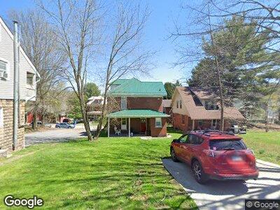
312 Dewey St Morgantown, WV 26501
South Park NeighborhoodEstimated Value: $224,000 - $306,000
4
Beds
3
Baths
1,561
Sq Ft
$174/Sq Ft
Est. Value
About This Home
This home is located at 312 Dewey St, Morgantown, WV 26501 and is currently estimated at $271,620, approximately $174 per square foot. 312 Dewey St is a home located in Monongalia County with nearby schools including Mountainview Elementary School, South Middle School, and Morgantown High School.
Ownership History
Date
Name
Owned For
Owner Type
Purchase Details
Closed on
Jul 22, 2020
Sold by
Ageless Enterprises Llc
Bought by
Ellis Erin L
Current Estimated Value
Home Financials for this Owner
Home Financials are based on the most recent Mortgage that was taken out on this home.
Original Mortgage
$229,620
Outstanding Balance
$207,206
Interest Rate
3.1%
Mortgage Type
New Conventional
Estimated Equity
$76,617
Purchase Details
Closed on
Jul 20, 2016
Sold by
Fortuna Rentals 1 Llc
Bought by
Ageless Enterprises Llc
Create a Home Valuation Report for This Property
The Home Valuation Report is an in-depth analysis detailing your home's value as well as a comparison with similar homes in the area
Home Values in the Area
Average Home Value in this Area
Purchase History
| Date | Buyer | Sale Price | Title Company |
|---|---|---|---|
| Ellis Erin L | $258,000 | None Available | |
| Ageless Enterprises Llc | $60,000 | None Available |
Source: Public Records
Mortgage History
| Date | Status | Borrower | Loan Amount |
|---|---|---|---|
| Open | Ellis Erin L | $229,620 |
Source: Public Records
Tax History Compared to Growth
Tax History
| Year | Tax Paid | Tax Assessment Tax Assessment Total Assessment is a certain percentage of the fair market value that is determined by local assessors to be the total taxable value of land and additions on the property. | Land | Improvement |
|---|---|---|---|---|
| 2024 | $1,216 | $92,400 | $34,800 | $57,600 |
| 2023 | $1,216 | $87,060 | $34,800 | $52,260 |
| 2022 | $1,098 | $86,100 | $34,800 | $51,300 |
| 2021 | $1,102 | $86,100 | $34,800 | $51,300 |
| 2020 | $1,754 | $68,280 | $34,800 | $33,480 |
| 2019 | $1,764 | $68,280 | $34,800 | $33,480 |
| 2018 | $1,769 | $68,280 | $34,800 | $33,480 |
| 2017 | $1,725 | $66,300 | $32,820 | $33,480 |
| 2016 | $1,652 | $63,180 | $29,700 | $33,480 |
| 2015 | $1,530 | $60,660 | $27,180 | $33,480 |
| 2014 | $1,491 | $61,380 | $25,140 | $36,240 |
Source: Public Records
Map
Nearby Homes
- 309 Green St
- 216 Reay Alley
- 313 Kingwood St
- 401 Conn St
- 332 E Brockway Ave
- 629 Brockway Ave
- 574 Pennsylvania Ave
- 204 Kingwood St
- 301 E Brockway Ave
- 416 E Brockway Ave
- 445 Harner St
- 315 Nolan Ave
- 0 Posten Ave Unit 10158671
- 320 Ash St
- 436 Pennsylvania Ave
- 125 Park St
- 313 Grand St
- 293 Franklin St
- 236 Cobun Ave
- TBD Buckhannon Ave