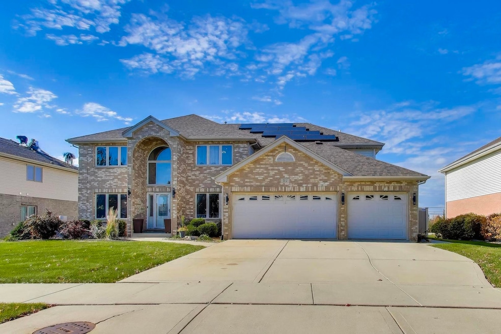
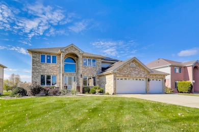
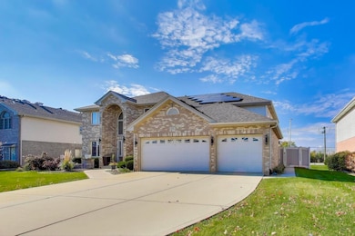
312 Grafton Place Matteson, IL 60443
Old Matteson NeighborhoodEstimated payment $3,752/month
Highlights
- Popular Property
- Wood Flooring
- Double Oven
- Deck
- Formal Dining Room
- Skylights
About This Home
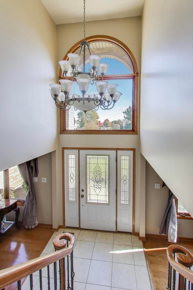
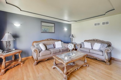
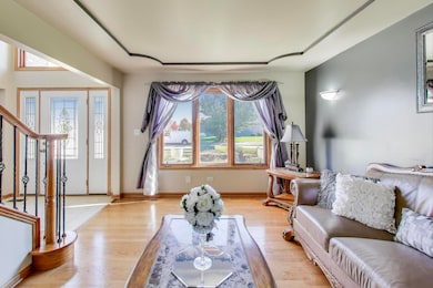
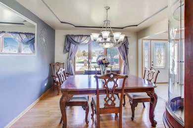
Welcome to 312 Grafton Place, a stunning 2-story home located in the highly sought-after Butterfield Place subdivision! This spacious residence offers 4 bedrooms and 2.5 baths, plus a fully finished basement with 2 additional rooms and a full bathroom making it a true 6-bedroom, 3.5-bath home with plenty of room for everyone. Step inside to soaring ceilings and a bright, open layout perfect for entertaining. The family room features a cozy fireplace and flows seamlessly into the large eat-in kitchen with a breakfast bar, ample cabinet space, and an adjoining dining area. A formal living room, separate dining room, and main-level laundry add both function and style. Upstairs, the primary suite offers a relaxing retreat with a walk-in closet, soaking tub, and separate shower. Three additional bedrooms and a full bathroom complete the second level. The finished basement expands your living space with two additional bedrooms, a full bath, wet bar, and a large recreation area perfect for guests, in-laws, or a home theater setup. Enjoy outdoor living with a on the back deck overlooking a spacious private backyard and a 3-car garage for all your storage needs. Conveniently located near shopping, dining, and expressways, this home delivers the perfect blend of comfort, space, and location. Don't miss your chance to call this beautiful Butterfield Place home yours, schedule your private tour today!
Listing Agent
@properties Christie's International Real Estate License #475207924 Listed on: 11/01/2025

Open House Schedule
-
Saturday, November 15, 202512:00 to 4:00 pm11/15/2025 12:00:00 PM +00:0011/15/2025 4:00:00 PM +00:00Add to Calendar
-
Sunday, November 16, 202510:00 am to 2:00 pm11/16/2025 10:00:00 AM +00:0011/16/2025 2:00:00 PM +00:00Add to Calendar
Home Details
Home Type
- Single Family
Est. Annual Taxes
- $13,096
Year Built
- Built in 2001
Lot Details
- 0.29 Acre Lot
- Lot Dimensions are 90x140
HOA Fees
- $31 Monthly HOA Fees
Parking
- 3 Car Garage
- Driveway
Home Design
- Brick Exterior Construction
- Asphalt Roof
- Concrete Perimeter Foundation
Interior Spaces
- 3,301 Sq Ft Home
- 2-Story Property
- Skylights
- Fireplace With Gas Starter
- Family Room with Fireplace
- Living Room
- Formal Dining Room
Kitchen
- Double Oven
- Gas Cooktop
- Microwave
- Dishwasher
- Disposal
Flooring
- Wood
- Carpet
- Laminate
- Ceramic Tile
Bedrooms and Bathrooms
- 6 Bedrooms
- 6 Potential Bedrooms
- Soaking Tub
Laundry
- Laundry Room
- Sink Near Laundry
- Gas Dryer Hookup
Basement
- Basement Fills Entire Space Under The House
- Finished Basement Bathroom
Outdoor Features
- Deck
- Patio
- Shed
Utilities
- Forced Air Heating and Cooling System
- Heating System Uses Natural Gas
- Lake Michigan Water
Community Details
- Exclusive Property Mgmt Association, Phone Number (708) 720-2009
- Butterfield Place Subdivision
- Property managed by Butterfield Place III HOA
Map
Home Values in the Area
Average Home Value in this Area
Tax History
| Year | Tax Paid | Tax Assessment Tax Assessment Total Assessment is a certain percentage of the fair market value that is determined by local assessors to be the total taxable value of land and additions on the property. | Land | Improvement |
|---|---|---|---|---|
| 2024 | $13,096 | $35,000 | $6,921 | $28,079 |
| 2023 | $12,511 | $35,000 | $6,921 | $28,079 |
| 2022 | $12,511 | $26,483 | $5,977 | $20,506 |
| 2021 | $12,731 | $26,481 | $5,976 | $20,505 |
| 2020 | $11,907 | $26,481 | $5,976 | $20,505 |
| 2019 | $10,953 | $24,592 | $5,347 | $19,245 |
| 2018 | $10,948 | $24,592 | $5,347 | $19,245 |
| 2017 | $10,540 | $24,592 | $5,347 | $19,245 |
| 2016 | $9,857 | $22,543 | $4,718 | $17,825 |
| 2015 | $9,710 | $22,543 | $4,718 | $17,825 |
| 2014 | $11,543 | $27,014 | $4,718 | $22,296 |
| 2013 | $12,146 | $30,769 | $4,718 | $26,051 |
Property History
| Date | Event | Price | List to Sale | Price per Sq Ft |
|---|---|---|---|---|
| 11/01/2025 11/01/25 | For Sale | $500,000 | -- | $151 / Sq Ft |
Purchase History
| Date | Type | Sale Price | Title Company |
|---|---|---|---|
| Deed | $332,500 | -- |
Mortgage History
| Date | Status | Loan Amount | Loan Type |
|---|---|---|---|
| Open | $315,750 | Unknown |
Source: Midwest Real Estate Data (MRED)
MLS Number: 12506423
APN: 31-15-315-014-0000
Disclaimer: Certain information contained herein is derived from information provided by parties other than Homes.com. All information provided is deemed reliable, but is not guaranteed to be accurate and should be independently verified.
![]() Based on information submitted to the MLS GRID. All data is obtained from various sources and may not have been verified by broker or MLS GRID. Supplied Open House Information is subject to change without notice. All information should be independently reviewed and verified for accuracy. Properties may or may not be listed by the office/agent presenting the information. Some IDX listings have been excluded from this website.
Based on information submitted to the MLS GRID. All data is obtained from various sources and may not have been verified by broker or MLS GRID. Supplied Open House Information is subject to change without notice. All information should be independently reviewed and verified for accuracy. Properties may or may not be listed by the office/agent presenting the information. Some IDX listings have been excluded from this website.
The Digital Millennium Copyright Act of 1998, 17 U.S.C. § 512 (the “DMCA”) provides recourse for copyright owners who believe that material appearing on the Internet infringes their rights under U.S. copyright law. If you believe in good faith that any content or material made available in connection with our website or services infringes your copyright, you (or your agent) may send us a notice requesting that the content or material be removed, or access to it blocked.
Notices must be sent in writing by email to DMCAnotice@MLSGrid.com.
The DMCA requires that your notice of alleged copyright infringement include the following information:
(1) description of the copyrighted work that is the subject of claimed infringement;
(2) description of the alleged infringing content and information sufficient to permit us to locate the content;
(3) contact information for you, including your address, telephone number and email address;
(4) a statement by you that you have a good faith belief that the content in the manner complained of is not authorized by the copyright owner, or its agent, or by the operation of any law;
(5) a statement by you, signed under penalty of perjury, that the information in the notification is accurate and that you have the authority to enforce the copyrights that are claimed to be infringed; and
(6) a physical or electronic signature of the copyright owner or a person authorized to act on the copyright owner’s behalf. Failure to include all of the above information may result in the delay of the processing of your complaint.
- 4700 203rd St
- 4500 203rd St
- 98 Lawrence Ln
- 175 Owen St
- 222 Owen St
- 663 Primrose Ln
- 202 Owen St
- 192 Owen St
- 153 Treehouse Rd
- 135 Treehouse Rd
- 72 Kenneth St
- 820 School Ave
- 858 Academy Ave
- 340 Maryview Ct
- 5345 Stanford Ln
- 4325 Oakwood Ln
- 255 Central Ave
- 4613 Lindenwood Ct
- 4329 Applewood Ln
- 322 Central Ave
- 77 Henson Ct
- 4962 Bennett St
- 716 Cambridge Ave
- 813 Cambridge Ave
- 4302 Applewood Ln
- 707 Rose Ln
- 4327 Lindenwood Dr
- 4046 Lindenwood Dr
- 42 Deerpath Rd
- 20408 Ithaca Rd
- 21227 S Jeffrey Dr
- 4135 193rd St Unit 268
- 4061 Charleston Rd Unit 3E
- 4920 Lake Ct Unit ID1285035P
- 753 Willow Rd
- 4032 216th St Unit 1E
- 623 Quail Run Rd Unit ID1285027P
- 6213 Beaver Dam Rd Unit ID1285022P
- 5000 190th St Unit ID1285036P
- 21149 Main St