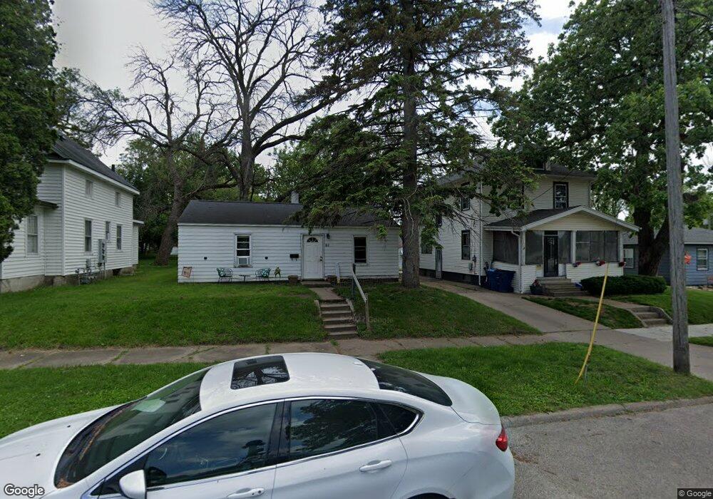
312 Lester St Waterloo, IA 50703
Roosevelt NeighborhoodEstimated Value: $55,000 - $287,708
2
Beds
1
Bath
682
Sq Ft
$176/Sq Ft
Est. Value
About This Home
This home is located at 312 Lester St, Waterloo, IA 50703 and is currently estimated at $120,177, approximately $176 per square foot. 312 Lester St is a home located in Black Hawk County with nearby schools including Cunningham School, George Washington Carver Academy, and East High School.
Ownership History
Date
Name
Owned For
Owner Type
Purchase Details
Closed on
Aug 15, 2022
Sold by
Hawthorne Rentals Llc
Bought by
Ag Evolution Llc
Current Estimated Value
Purchase Details
Closed on
Nov 10, 2010
Sold by
Keniston Emily A and Keniston Jonathan
Bought by
Co Hawthorne Rentals Llc
Home Financials for this Owner
Home Financials are based on the most recent Mortgage that was taken out on this home.
Original Mortgage
$32,000
Interest Rate
4.17%
Mortgage Type
Purchase Money Mortgage
Purchase Details
Closed on
Sep 29, 2005
Sold by
Devore Properties Inc
Bought by
Keniston Emily A and Keniston Jonathan
Home Financials for this Owner
Home Financials are based on the most recent Mortgage that was taken out on this home.
Original Mortgage
$20,000
Interest Rate
5.88%
Mortgage Type
New Conventional
Create a Home Valuation Report for This Property
The Home Valuation Report is an in-depth analysis detailing your home's value as well as a comparison with similar homes in the area
Home Values in the Area
Average Home Value in this Area
Purchase History
| Date | Buyer | Sale Price | Title Company |
|---|---|---|---|
| Ag Evolution Llc | $305,000 | None Listed On Document | |
| Ag Evolution Llc | $305,000 | None Listed On Document | |
| Co Hawthorne Rentals Llc | $25,000 | None Available | |
| Keniston Emily A | $25,000 | None Available |
Source: Public Records
Mortgage History
| Date | Status | Borrower | Loan Amount |
|---|---|---|---|
| Previous Owner | Co Hawthorne Rentals Llc | $32,000 | |
| Previous Owner | Keniston Emily A | $20,000 |
Source: Public Records
Tax History
| Year | Tax Paid | Tax Assessment Tax Assessment Total Assessment is a certain percentage of the fair market value that is determined by local assessors to be the total taxable value of land and additions on the property. | Land | Improvement |
|---|---|---|---|---|
| 2025 | $544 | $29,110 | $6,060 | $23,050 |
| 2024 | $544 | $25,040 | $6,060 | $18,980 |
| 2023 | $442 | $25,040 | $6,060 | $18,980 |
| 2022 | $432 | $20,170 | $6,060 | $14,110 |
| 2021 | $456 | $20,170 | $6,060 | $14,110 |
| 2020 | $450 | $20,170 | $6,060 | $14,110 |
| 2019 | $450 | $20,170 | $6,060 | $14,110 |
| 2018 | $450 | $20,170 | $6,060 | $14,110 |
| 2017 | $464 | $20,170 | $6,060 | $14,110 |
| 2016 | $458 | $20,170 | $6,060 | $14,110 |
| 2015 | $458 | $20,170 | $6,060 | $14,110 |
| 2014 | $466 | $20,170 | $6,060 | $14,110 |
Source: Public Records
Map
Nearby Homes
- 2207 E 4th St
- 211 Boston Ave
- Lot 13, 14, 15 Gable St
- 303 E Arlington St
- 230 Gable St
- 127 Sherman Ave
- 117 Sherman Ave
- 68 E Parker St
- 101 Ricker St
- 516 Cutler St
- 1103-1107 Logan Ave
- 523 Cutler St
- 617 Boston Ave
- 626 Boston Ave
- 144 Kern St
- 533 Reed St
- 630 Webster St
- 232 Webster St
- Lot 11 & 12 Webster St
- 116 Conger St
Your Personal Tour Guide
Ask me questions while you tour the home.