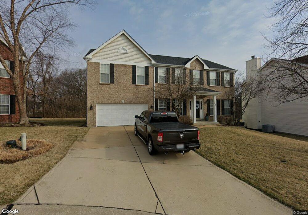
312 Panhurst Ct Ballwin, MO 63021
Estimated Value: $527,659 - $574,000
4
Beds
3
Baths
3,136
Sq Ft
$178/Sq Ft
Est. Value
About This Home
This home is located at 312 Panhurst Ct, Ballwin, MO 63021 and is currently estimated at $558,665, approximately $178 per square foot. 312 Panhurst Ct is a home located in St. Louis County with nearby schools including Ridge Meadows Elementary School, Selvidge Middle School, and Marquette Sr. High School.
Ownership History
Date
Name
Owned For
Owner Type
Purchase Details
Closed on
Feb 8, 2001
Sold by
Davis Daniel W and Leigh Tammy
Bought by
Davis Daniel W and Davis Tammy L
Current Estimated Value
Purchase Details
Closed on
Dec 12, 1997
Sold by
The Jones Company Custom Homes Inc
Bought by
Davis Daniel W and Davis Tammy Leigh
Home Financials for this Owner
Home Financials are based on the most recent Mortgage that was taken out on this home.
Original Mortgage
$136,000
Interest Rate
7.2%
Create a Home Valuation Report for This Property
The Home Valuation Report is an in-depth analysis detailing your home's value as well as a comparison with similar homes in the area
Home Values in the Area
Average Home Value in this Area
Purchase History
| Date | Buyer | Sale Price | Title Company |
|---|---|---|---|
| Davis Daniel W | -- | -- | |
| Davis Daniel W | -- | -- |
Source: Public Records
Mortgage History
| Date | Status | Borrower | Loan Amount |
|---|---|---|---|
| Closed | Davis Daniel W | $136,000 |
Source: Public Records
Tax History
| Year | Tax Paid | Tax Assessment Tax Assessment Total Assessment is a certain percentage of the fair market value that is determined by local assessors to be the total taxable value of land and additions on the property. | Land | Improvement |
|---|---|---|---|---|
| 2025 | $6,276 | $95,610 | $27,820 | $67,790 |
| 2024 | $6,276 | $89,850 | $15,450 | $74,400 |
| 2023 | $6,271 | $89,850 | $15,450 | $74,400 |
| 2022 | $5,559 | $73,940 | $18,540 | $55,400 |
| 2021 | $5,518 | $73,940 | $18,540 | $55,400 |
| 2020 | $5,353 | $68,380 | $18,540 | $49,840 |
| 2019 | $5,375 | $68,380 | $18,540 | $49,840 |
| 2018 | $5,313 | $63,730 | $13,910 | $49,820 |
| 2017 | $5,186 | $63,730 | $13,910 | $49,820 |
| 2016 | $5,189 | $61,320 | $13,910 | $47,410 |
Source: Public Records
Map
Nearby Homes
- 439 Chukker Valley
- 16015 Canterbury Estates Dr
- 217 Carmel Woods Dr Unit 217
- 1396 Parkview Estates Dr
- 16038 Pierside Ln
- 847 Arbor Chase Dr
- 16016 Cinderella Ct
- 16033 Cinderella Ct
- 2 Burlington at Regal Pines Meadows
- 16008 Cinderella Ct
- 16004 Cinderella Ct
- 2 Meadows
- 2 Belmont at Regal Pines Meadows
- 2 Nottingham at Regal Pines Enclave
- 2 Hickory at Regal Pines Enclave
- 589 Wetherby Terrace Dr
- 2 Sequoia at Regal Pines Enclave
- 2 Hermitage II at Regal Pines Enclave
- 2 Pin Oak at Regal Pines Enclave
- 2 Maple Expanded at Regal Pines Enclave
- 318 Panhurst Ct
- 306 Panhurst Ct
- 324 Panhurst Ct
- 300 Panhurst Ct
- 317 Panhurst Ct
- 657 Woodhill Estates Dr
- 311 Panhurst Ct
- 330 Panhurst Ct
- 305 Panhurst Ct
- 335 Panhurst Ct
- 649 Woodhill Estates Dr
- 336 Panhurst Ct
- 1517 Thornridge Ct
- 1525 Thornridge Ct
- 1509 Thornridge Ct
- 1533 Thornridge Ct
- 1501 Thornridge Ct
- 641 Woodhill Estates Dr
- 1541 Thornridge Ct
- 342 Panhurst Ct
Your Personal Tour Guide
Ask me questions while you tour the home.