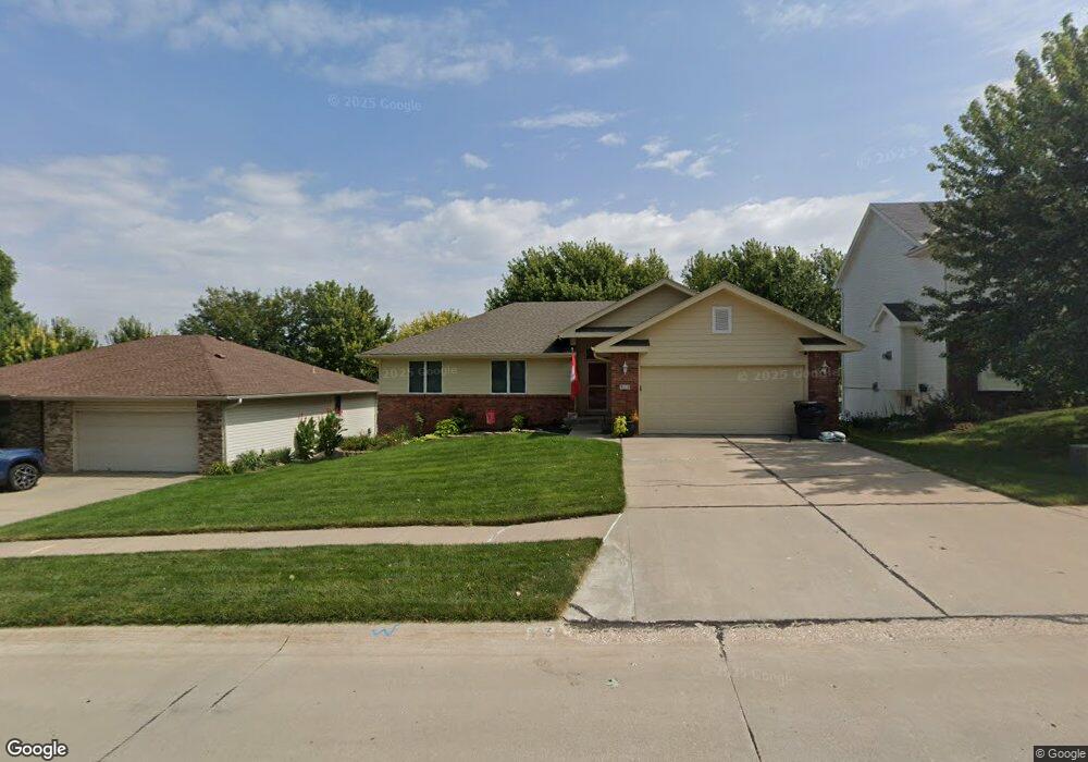
313 W Ferndale Dr Council Bluffs, IA 51503
Eastern Council Bluffs NeighborhoodEstimated Value: $339,000 - $365,000
3
Beds
3
Baths
1,311
Sq Ft
$266/Sq Ft
Est. Value
About This Home
This home is located at 313 W Ferndale Dr, Council Bluffs, IA 51503 and is currently estimated at $349,162, approximately $266 per square foot. 313 W Ferndale Dr is a home located in Pottawattamie County with nearby schools including E.A. Kreft Primary School, Titan Hill Intermediate School, and Lewis Central Middle School.
Ownership History
Date
Name
Owned For
Owner Type
Purchase Details
Closed on
Jul 29, 2021
Sold by
Felker Barbara R and The Barbara R Felker Family Tr
Bought by
Minshall John J and Minshall Melissa E
Current Estimated Value
Home Financials for this Owner
Home Financials are based on the most recent Mortgage that was taken out on this home.
Original Mortgage
$260,200
Outstanding Balance
$236,602
Interest Rate
2.9%
Mortgage Type
FHA
Estimated Equity
$112,560
Create a Home Valuation Report for This Property
The Home Valuation Report is an in-depth analysis detailing your home's value as well as a comparison with similar homes in the area
Home Values in the Area
Average Home Value in this Area
Purchase History
| Date | Buyer | Sale Price | Title Company |
|---|---|---|---|
| Minshall John J | $265,000 | None Available |
Source: Public Records
Mortgage History
| Date | Status | Borrower | Loan Amount |
|---|---|---|---|
| Open | Minshall John J | $260,200 |
Source: Public Records
Tax History Compared to Growth
Tax History
| Year | Tax Paid | Tax Assessment Tax Assessment Total Assessment is a certain percentage of the fair market value that is determined by local assessors to be the total taxable value of land and additions on the property. | Land | Improvement |
|---|---|---|---|---|
| 2025 | $5,272 | $312,800 | $45,400 | $267,400 |
| 2024 | $5,272 | $285,500 | $39,500 | $246,000 |
| 2023 | $4,940 | $285,500 | $39,500 | $246,000 |
| 2022 | $4,044 | $238,500 | $37,500 | $201,000 |
| 2021 | $6,177 | $212,500 | $37,500 | $175,000 |
| 2020 | $4,048 | $212,500 | $37,500 | $175,000 |
| 2019 | $4,218 | $195,300 | $32,419 | $162,881 |
| 2018 | $4,118 | $195,300 | $32,419 | $162,881 |
| 2017 | $4,194 | $195,300 | $32,419 | $162,881 |
| 2015 | $4,010 | $190,515 | $32,419 | $158,096 |
| 2014 | $4,032 | $190,515 | $32,419 | $158,096 |
Source: Public Records
Map
Nearby Homes
- 212 Woodcliff Cir
- 310 Wildwood Rd
- 206 Parkview Dr
- LOT 12 Mcpherson Ave
- 200 Timber Dr
- 208 Red Bud Ln
- 2526 Franklin Ave
- 128 Charles Park Dr
- 1715 Blackthorn St
- 1711 Blackthorn St
- 131 Norwood Dr
- 1742 Blackthorn St
- 1759 Blackthorn St
- 23 Wenwood Cir
- 16090 Crystal Ln
- 1768 Blackthorn St
- 37 Indian Hills Rd
- 1835 Balsam St
- 1873 Hemlock St
- 1893 Hemlock St
- 317 W Ferndale Dr
- 309 W Ferndale Dr
- 312 E Ferndale Dr
- 305 W Ferndale Dr
- 321 W Ferndale Dr
- 316 E Ferndale Dr
- 308 E Ferndale Dr
- 306 W Ferndale Dr
- 320 E Ferndale Dr
- 304 E Ferndale Dr
- 310 W Ferndale Dr
- 325 W Ferndale Dr
- 301 W Ferndale Dr
- 225 Canterbury Cir
- 324 E Ferndale Dr
- 20 Canterbury Cir
- 17 Canterbury Cir
- 314 Leeds Cir
- 300 E Ferndale Dr
- 229 Canterbury Cir