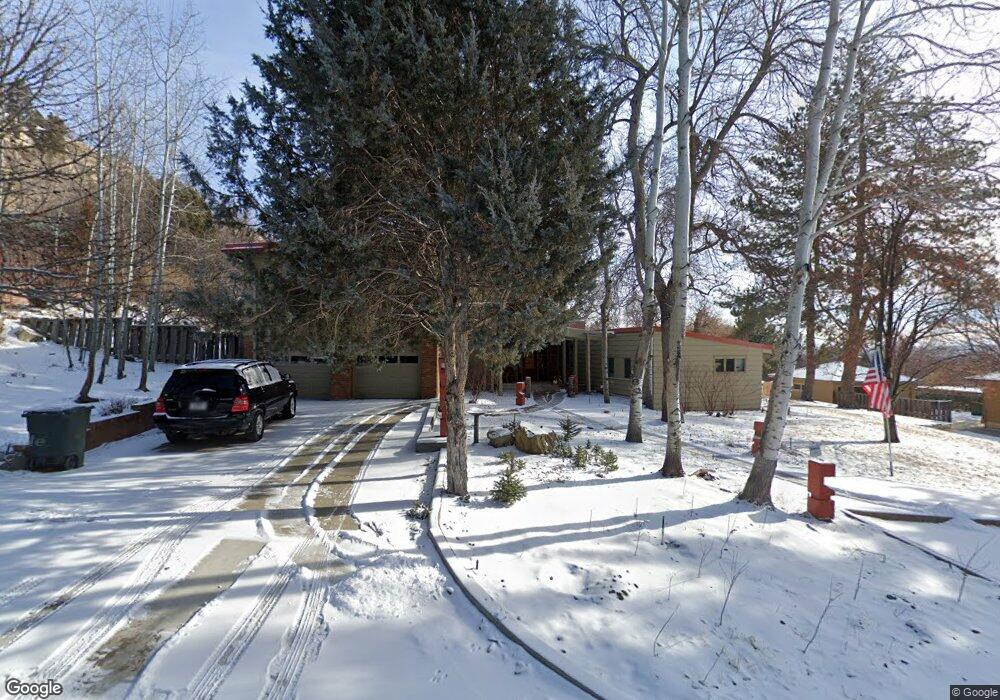
3131 Harrow Dr Billings, MT 59102
North Central Billings NeighborhoodEstimated Value: $525,000 - $609,000
6
Beds
4
Baths
3,669
Sq Ft
$154/Sq Ft
Est. Value
About This Home
This home is located at 3131 Harrow Dr, Billings, MT 59102 and is currently estimated at $563,839, approximately $153 per square foot. 3131 Harrow Dr is a home located in Yellowstone County with nearby schools including Rose Park School, Lewis & Clark Junior High School, and Billings Senior High School.
Ownership History
Date
Name
Owned For
Owner Type
Purchase Details
Closed on
Sep 26, 2016
Sold by
Marble Fred W and Marble Mary A
Bought by
Dawson Michael K and Dafoe Dawson Maureen E
Current Estimated Value
Home Financials for this Owner
Home Financials are based on the most recent Mortgage that was taken out on this home.
Original Mortgage
$250,000
Outstanding Balance
$200,231
Interest Rate
3.43%
Mortgage Type
New Conventional
Estimated Equity
$363,608
Create a Home Valuation Report for This Property
The Home Valuation Report is an in-depth analysis detailing your home's value as well as a comparison with similar homes in the area
Home Values in the Area
Average Home Value in this Area
Purchase History
| Date | Buyer | Sale Price | Title Company |
|---|---|---|---|
| Dawson Michael K | -- | American Title & Escrow |
Source: Public Records
Mortgage History
| Date | Status | Borrower | Loan Amount |
|---|---|---|---|
| Open | Dawson Michael K | $250,000 |
Source: Public Records
Tax History
| Year | Tax Paid | Tax Assessment Tax Assessment Total Assessment is a certain percentage of the fair market value that is determined by local assessors to be the total taxable value of land and additions on the property. | Land | Improvement |
|---|---|---|---|---|
| 2025 | $6,847 | $523,300 | $75,194 | $448,106 |
| 2024 | $6,847 | $469,200 | $70,946 | $398,254 |
| 2023 | $6,850 | $469,200 | $70,946 | $398,254 |
| 2022 | $3,730 | $395,000 | $0 | $0 |
| 2021 | $4,204 | $395,000 | $0 | $0 |
| 2020 | $4,148 | $373,800 | $0 | $0 |
| 2019 | $3,960 | $373,800 | $0 | $0 |
| 2018 | $3,895 | $361,100 | $0 | $0 |
| 2017 | $3,783 | $361,100 | $0 | $0 |
| 2016 | $3,717 | $360,500 | $0 | $0 |
| 2015 | $3,634 | $360,500 | $0 | $0 |
| 2014 | $3,125 | $163,187 | $0 | $0 |
Source: Public Records
Map
Nearby Homes
- 1449 Teton Ave
- 1440 Granite Ave
- 3016 Radcliffe Dr
- 1313 Granite Ave
- 1305 Rimrock Rd
- 13 Stanford Ct
- 3118 Ramada Dr
- 1238 Princeton Ave
- 3114 Lohof Dr
- 1400 Poly Dr Unit 4D
- 3103 Silverwood St
- 41 Heatherwood Ln
- 9 Shadow Place
- 56 Shadow Place
- 1833 Iris Ln
- 3226 Country Club Cir
- 2202 13th St W
- 2958 Rockrim Ln
- 2095 17th St W
- 1807 S Mariposa Ln
- 3205 Harrow Dr
- 3115 Harrow Dr
- 3126 Glacier Dr
- 3120 Glacier Dr
- 3120 Harrow Dr
- 3202 Harrow Dr
- 3111 Harrow Dr
- 3110 Harrow Dr
- 3112 Glacier Dr
- 3210 Harrow Dr
- 3225 Harrow Dr
- 3107 Harrow Dr
- 3104 Glacier Dr
- 1445 Granite Ave
- 1448 Granite Ave
- 3201 Rugby Dr
- 3225 Rugby Dr
- 3100 Harrow Dr
- 3013 Harrow Dr
- 3207 Rugby Dr
Your Personal Tour Guide
Ask me questions while you tour the home.