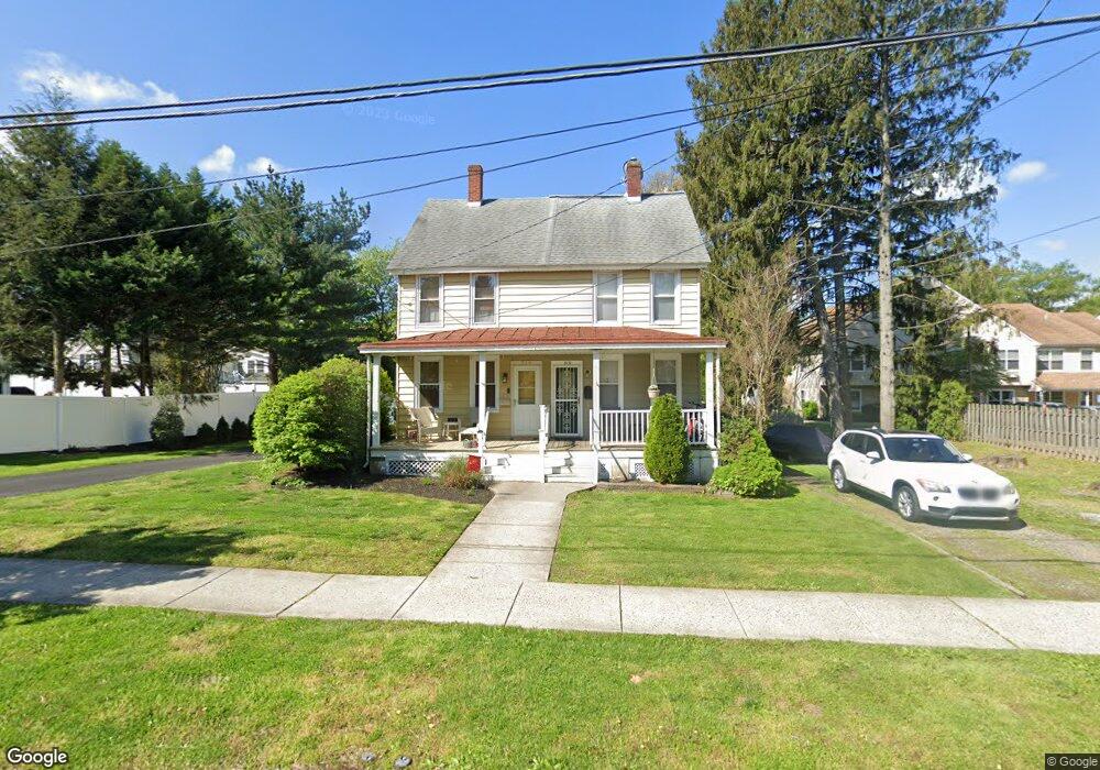
314 Pearl St Moorestown, NJ 08057
Estimated Value: $311,000 - $426,000
--
Bed
--
Bath
1,088
Sq Ft
$327/Sq Ft
Est. Value
About This Home
This home is located at 314 Pearl St, Moorestown, NJ 08057 and is currently estimated at $355,271, approximately $326 per square foot. 314 Pearl St is a home located in Burlington County with nearby schools including South Valley Elementary School, Moorestown Upper Elementary School, and William Allen Middle School.
Ownership History
Date
Name
Owned For
Owner Type
Purchase Details
Closed on
Sep 16, 2005
Sold by
Full Circle Builders Llc
Bought by
Maletteri Jenna
Current Estimated Value
Home Financials for this Owner
Home Financials are based on the most recent Mortgage that was taken out on this home.
Original Mortgage
$201,875
Outstanding Balance
$108,139
Interest Rate
5.87%
Mortgage Type
Fannie Mae Freddie Mac
Estimated Equity
$247,132
Purchase Details
Closed on
Sep 9, 2005
Sold by
Gottardi Ronald and Gottardi Flora A
Bought by
Canton John D
Home Financials for this Owner
Home Financials are based on the most recent Mortgage that was taken out on this home.
Original Mortgage
$201,875
Outstanding Balance
$108,139
Interest Rate
5.87%
Mortgage Type
Fannie Mae Freddie Mac
Estimated Equity
$247,132
Create a Home Valuation Report for This Property
The Home Valuation Report is an in-depth analysis detailing your home's value as well as a comparison with similar homes in the area
Home Values in the Area
Average Home Value in this Area
Purchase History
| Date | Buyer | Sale Price | Title Company |
|---|---|---|---|
| Maletteri Jenna | $212,000 | Infinity Title Agency Inc | |
| Full Circle Builders Llc | -- | Infinity Title Agency Inc | |
| Canton John D | -- | Infinity Title Agency Inc |
Source: Public Records
Mortgage History
| Date | Status | Borrower | Loan Amount |
|---|---|---|---|
| Open | Full Circle Builders Llc | $201,875 |
Source: Public Records
Tax History Compared to Growth
Tax History
| Year | Tax Paid | Tax Assessment Tax Assessment Total Assessment is a certain percentage of the fair market value that is determined by local assessors to be the total taxable value of land and additions on the property. | Land | Improvement |
|---|---|---|---|---|
| 2025 | $4,539 | $160,000 | $120,000 | $40,000 |
| 2024 | $4,402 | $160,000 | $120,000 | $40,000 |
| 2023 | $4,402 | $160,000 | $120,000 | $40,000 |
| 2022 | $4,357 | $160,000 | $120,000 | $40,000 |
| 2021 | $4,299 | $160,000 | $120,000 | $40,000 |
| 2020 | $4,272 | $160,000 | $120,000 | $40,000 |
| 2019 | $4,197 | $160,000 | $120,000 | $40,000 |
| 2018 | $4,083 | $160,000 | $120,000 | $40,000 |
| 2017 | $4,118 | $160,000 | $120,000 | $40,000 |
| 2016 | $4,104 | $160,000 | $120,000 | $40,000 |
| 2015 | $4,619 | $182,300 | $134,700 | $47,600 |
| 2014 | $4,386 | $182,300 | $134,700 | $47,600 |
Source: Public Records
Map
Nearby Homes
- 308 Elm St
- 408 E 2nd St
- 205 E Central Ave
- 514 E Main St
- 526 E Main St
- 133 Plum St Unit 6
- 633 E Main St Unit B7
- 80 E 3rd St
- 82 E 3rd St
- 66 E 3rd St
- 50 E 3rd St
- 744 Signal Light Rd
- 15 E 2nd St
- 863 Golf View Rd
- 5 E Coach Ln
- 32 Michaelson Dr
- 11 E Sutton Ave
- 4 E Sutton Ave
- 129 S Church St
- 310 S Washington Ave