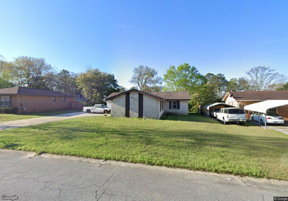
314 Rusty Rd Warner Robins, GA 31088
Estimated Value: $161,608 - $175,000
Studio
2
Baths
1,268
Sq Ft
$133/Sq Ft
Est. Value
About This Home
This home is located at 314 Rusty Rd, Warner Robins, GA 31088 and is currently estimated at $168,652, approximately $133 per square foot. 314 Rusty Rd is a home located in Houston County with nearby schools including Russell Elementary School, Warner Robins Middle School, and Warner Robins High School.
Ownership History
Date
Name
Owned For
Owner Type
Purchase Details
Closed on
Jun 3, 1994
Sold by
Gaines Timothy L and Gaines Blaze*
Bought by
Innie Clance C and Innie R*
Current Estimated Value
Purchase Details
Closed on
Oct 30, 1992
Sold by
Bodine John D and Bodine Carolyn F
Bought by
Gaines Timothy L and Gaines Blaze*
Purchase Details
Closed on
Nov 18, 1988
Sold by
Abbott Robert B and Abbott Virginia E
Bought by
Bodine John D and Carolyn F*
Purchase Details
Closed on
Apr 2, 1979
Sold by
Richards Ii John W and Richards Pamela M
Bought by
Abbott Robert B and Virginia E*
Purchase Details
Closed on
Mar 16, 1976
Sold by
Citizens & Southern Mortgage Co
Bought by
Richards Ii John W and Richards Pamela M
Purchase Details
Closed on
May 6, 1975
Sold by
Brand & Howell Realty Co Inc
Bought by
C & S Mortgage Co
Purchase Details
Closed on
Aug 21, 1973
Sold by
S & W Development Co
Bought by
Brand & Howell Realty Co Inc
Create a Home Valuation Report for This Property
The Home Valuation Report is an in-depth analysis detailing your home's value as well as a comparison with similar homes in the area
Home Values in the Area
Average Home Value in this Area
Purchase History
| Date | Buyer | Sale Price | Title Company |
|---|---|---|---|
| Innie Clance C | $58,000 | -- | |
| Gaines Timothy L | $57,500 | -- | |
| Bodine John D | $52,900 | -- | |
| Abbott Robert B | -- | -- | |
| Richards Ii John W | $30,400 | -- | |
| C & S Mortgage Co | -- | -- | |
| Brand & Howell Realty Co Inc | -- | -- |
Source: Public Records
Tax History
| Year | Tax Paid | Tax Assessment Tax Assessment Total Assessment is a certain percentage of the fair market value that is determined by local assessors to be the total taxable value of land and additions on the property. | Land | Improvement |
|---|---|---|---|---|
| 2025 | $1,567 | $53,800 | $8,000 | $45,800 |
| 2024 | $1,664 | $50,840 | $8,000 | $42,840 |
| 2023 | $1,262 | $38,280 | $8,000 | $30,280 |
| 2022 | $780 | $33,920 | $5,200 | $28,720 |
| 2021 | $645 | $27,920 | $5,200 | $22,720 |
| 2020 | $639 | $27,520 | $5,200 | $22,320 |
| 2019 | $639 | $27,520 | $5,200 | $22,320 |
| 2018 | $639 | $27,520 | $5,200 | $22,320 |
| 2017 | $640 | $27,520 | $5,200 | $22,320 |
| 2016 | $641 | $27,520 | $5,200 | $22,320 |
| 2015 | -- | $29,360 | $5,200 | $24,160 |
| 2014 | -- | $29,360 | $5,200 | $24,160 |
| 2013 | -- | $29,360 | $5,200 | $24,160 |
Source: Public Records
Map
Nearby Homes
- 114 Windsor Dr
- 223 Highland Dr
- 305 Bonnie Dr
- 223 Randy Cir
- 101 Sunnybrook Ct
- 107 Woodfield Dr
- 114 Tommy Terrace
- 302 Creek Ridge Dr
- 201 Bayside Dr
- 205 Sonja Dr
- 209 Tracy Terrace
- 213 Self St
- 1850 Russell Pkwy
- 0 Russell Pkwy Unit 10656199
- 222 Blue Ridge Ln
- 118 Fox Glove Ct
- 25 & 26 Lot
- 236 Tallulah Trail
- 510 Arrowhead Trail
- 226 Shenandoah Trail
Your Personal Tour Guide
Ask me questions while you tour the home.