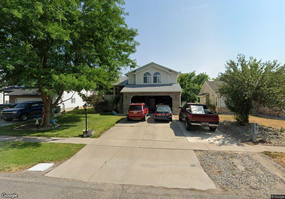
314 W 1330 N Logan, UT 84341
Bridger NeighborhoodEstimated Value: $408,000 - $432,299
5
Beds
3
Baths
2,218
Sq Ft
$188/Sq Ft
Est. Value
About This Home
This home is located at 314 W 1330 N, Logan, UT 84341 and is currently estimated at $417,575, approximately $188 per square foot. 314 W 1330 N is a home located in Cache County with nearby schools including Bridger School, Mount Logan Middle School, and Logan High School.
Ownership History
Date
Name
Owned For
Owner Type
Purchase Details
Closed on
Sep 27, 2017
Sold by
Wyatt Karen L
Bought by
Brannigan Amber J and Tadd Joshua R
Current Estimated Value
Home Financials for this Owner
Home Financials are based on the most recent Mortgage that was taken out on this home.
Original Mortgage
$221,160
Outstanding Balance
$183,392
Interest Rate
3.82%
Mortgage Type
New Conventional
Estimated Equity
$234,183
Purchase Details
Closed on
Jul 31, 2002
Sold by
Wyatt James E
Bought by
Wyatt Karen L
Create a Home Valuation Report for This Property
The Home Valuation Report is an in-depth analysis detailing your home's value as well as a comparison with similar homes in the area
Home Values in the Area
Average Home Value in this Area
Purchase History
| Date | Buyer | Sale Price | Title Company |
|---|---|---|---|
| Brannigan Amber J | -- | -- | |
| Wyatt Karen L | -- | -- |
Source: Public Records
Mortgage History
| Date | Status | Borrower | Loan Amount |
|---|---|---|---|
| Open | Brannigan Amber J | $221,160 |
Source: Public Records
Tax History
| Year | Tax Paid | Tax Assessment Tax Assessment Total Assessment is a certain percentage of the fair market value that is determined by local assessors to be the total taxable value of land and additions on the property. | Land | Improvement |
|---|---|---|---|---|
| 2025 | $174 | $225,285 | $0 | $0 |
| 2024 | $1,798 | $225,285 | $0 | $0 |
| 2023 | $1,877 | $224,075 | $0 | $0 |
| 2022 | $1,689 | $188,325 | $0 | $0 |
| 2021 | $1,642 | $282,930 | $45,000 | $237,930 |
| 2020 | $1,515 | $234,877 | $45,000 | $189,877 |
| 2019 | $1,583 | $234,876 | $45,000 | $189,876 |
| 2018 | $1,552 | $210,110 | $45,000 | $165,110 |
| 2017 | $1,460 | $104,555 | $0 | $0 |
| 2016 | $1,514 | $92,950 | $0 | $0 |
| 2015 | $1,299 | $89,605 | $0 | $0 |
| 2014 | $1,174 | $89,605 | $0 | $0 |
| 2013 | -- | $89,605 | $0 | $0 |
Source: Public Records
Map
Nearby Homes
- 2200 N 220 W
- 1555 N 280 W Unit 102
- 1515 N 450 W Unit 103
- 1368 N 590 W
- 1593 N 160 W Unit 201
- 1492 N 565 W Unit 103
- 723 W 1400 N Unit 3
- 1030 N 250 W
- 519 W 1570 N Unit 103
- 49 Kensington Place
- 948 N 480 W
- 2 Somerset Place
- 897 N 250 W
- 54 Kensington Place
- 905 N 540 W
- 1852 N 340 W
- 430 W 810 N
- 1926 Lavender Loop Unit 6
- 790 N 200 W
- 1903 N 300 W
Your Personal Tour Guide
Ask me questions while you tour the home.