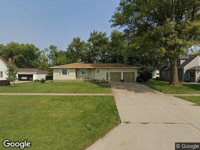
314 W Main St Cedar Bluffs, NE 68015
Estimated Value: $175,000 - $273,000
3
Beds
2
Baths
1,438
Sq Ft
$168/Sq Ft
Est. Value
About This Home
This home is located at 314 W Main St, Cedar Bluffs, NE 68015 and is currently estimated at $240,943, approximately $167 per square foot. 314 W Main St is a home located in Saunders County with nearby schools including Cedar Bluffs Elementary School and Cedar Bluffs High School.
Ownership History
Date
Name
Owned For
Owner Type
Purchase Details
Closed on
Sep 28, 2012
Sold by
Lubker Andrew J and Lubker Shannon M
Bought by
Ptomey Harlan R and Ptomey Noelle A
Current Estimated Value
Home Financials for this Owner
Home Financials are based on the most recent Mortgage that was taken out on this home.
Original Mortgage
$104,500
Interest Rate
3.61%
Mortgage Type
Stand Alone Refi Refinance Of Original Loan
Purchase Details
Closed on
Mar 22, 2011
Sold by
Grosse Garlyn and Grosse Bernice
Bought by
Grosse Garlyn
Purchase Details
Closed on
Mar 17, 2011
Sold by
Grosse Garlyn and Grosse Bernice
Bought by
Grosse Garlyn
Create a Home Valuation Report for This Property
The Home Valuation Report is an in-depth analysis detailing your home's value as well as a comparison with similar homes in the area
Home Values in the Area
Average Home Value in this Area
Purchase History
| Date | Buyer | Sale Price | Title Company |
|---|---|---|---|
| Ptomey Harlan R | -- | -- |
Source: Public Records
Mortgage History
| Date | Status | Borrower | Loan Amount |
|---|---|---|---|
| Open | Ptomey Harlan R | $89,000 | |
| Closed | Ptomey Harlan | $50,000 | |
| Closed | Ptomey Harlan R | $104,500 | |
| Previous Owner | Grosse Garlyn | $0 | |
| Previous Owner | Grosse Garlyn | $0 | |
| Previous Owner | Grosse Bernice E | $20,000 |
Source: Public Records
Tax History Compared to Growth
Tax History
| Year | Tax Paid | Tax Assessment Tax Assessment Total Assessment is a certain percentage of the fair market value that is determined by local assessors to be the total taxable value of land and additions on the property. | Land | Improvement |
|---|---|---|---|---|
| 2024 | $3,108 | $231,700 | $21,612 | $210,088 |
| 2023 | $4,273 | $228,198 | $21,612 | $206,586 |
| 2022 | $3,936 | $192,116 | $21,612 | $170,504 |
| 2021 | $3,423 | $158,367 | $21,612 | $136,755 |
| 2020 | $3,432 | $156,295 | $21,612 | $134,683 |
| 2019 | $3,159 | $137,660 | $21,610 | $116,050 |
| 2018 | $3,148 | $137,660 | $21,610 | $116,050 |
| 2017 | $286 | $123,680 | $21,610 | $102,070 |
| 2016 | $2,672 | $109,080 | $12,420 | $96,660 |
| 2015 | $2,776 | $109,080 | $12,420 | $96,660 |
| 2014 | $2,758 | $109,080 | $12,420 | $96,660 |
| 2012 | $2,426 | $85,200 | $13,700 | $71,500 |
Source: Public Records
Map
Nearby Homes
- 208 W Elm St
- 303 W Pine St
- 103 W Oak St
- 1673 County Road X
- 2596 Fox Run
- 2523 County Road 20
- 5101 Ventura Dr
- 3322 Big Island Rd
- 1780 County Rd S
- 2494 W Military Ave
- 324 S Woodland Ct
- 260 S Woodland Ct
- 1565 W Woodland Trail
- 1399 Woodland Cove Unit Lot 3
- 2811 Douglas Dr
- 1302 W South St Unit 8
- 2709 Eagle Dr
- 3593 Little Bluestem Rd
- 3587 Little Bluestem Rd
- 3575 Little Bluestem Rd