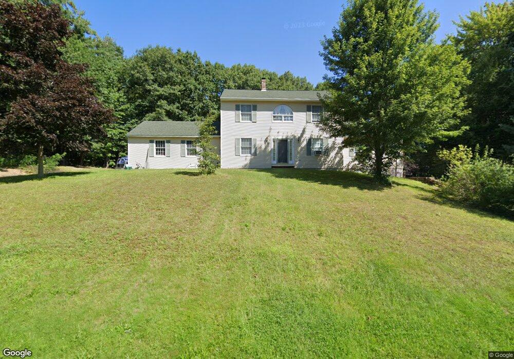
315 Hillcrest Dr Laconia, NH 03246
Estimated Value: $574,000 - $823,000
4
Beds
4
Baths
2,100
Sq Ft
$311/Sq Ft
Est. Value
About This Home
This home is located at 315 Hillcrest Dr, Laconia, NH 03246 and is currently estimated at $653,003, approximately $310 per square foot. 315 Hillcrest Dr is a home located in Belknap County with nearby schools including Laconia Middle School, Laconia High School, and Holy Trinity Catholic School.
Ownership History
Date
Name
Owned For
Owner Type
Purchase Details
Closed on
Mar 27, 2015
Sold by
Ross Mary A
Bought by
Ross David W
Current Estimated Value
Purchase Details
Closed on
Jan 14, 2000
Sold by
Drouin Bldrs Inc
Bought by
Ross David W and Ross Mary Anne
Home Financials for this Owner
Home Financials are based on the most recent Mortgage that was taken out on this home.
Original Mortgage
$140,000
Interest Rate
7.79%
Create a Home Valuation Report for This Property
The Home Valuation Report is an in-depth analysis detailing your home's value as well as a comparison with similar homes in the area
Home Values in the Area
Average Home Value in this Area
Purchase History
| Date | Buyer | Sale Price | Title Company |
|---|---|---|---|
| Ross David W | -- | -- | |
| Ross Mary A | -- | -- | |
| Ross David W | $185,000 | -- |
Source: Public Records
Mortgage History
| Date | Status | Borrower | Loan Amount |
|---|---|---|---|
| Previous Owner | Ross David W | $140,000 |
Source: Public Records
Tax History Compared to Growth
Tax History
| Year | Tax Paid | Tax Assessment Tax Assessment Total Assessment is a certain percentage of the fair market value that is determined by local assessors to be the total taxable value of land and additions on the property. | Land | Improvement |
|---|---|---|---|---|
| 2024 | $7,529 | $552,400 | $174,600 | $377,800 |
| 2023 | $7,304 | $525,100 | $160,800 | $364,300 |
| 2022 | $6,484 | $436,600 | $136,500 | $300,100 |
| 2021 | $6,518 | $345,600 | $76,400 | $269,200 |
| 2020 | $6,441 | $326,600 | $65,100 | $261,500 |
| 2019 | $6,609 | $321,000 | $59,500 | $261,500 |
| 2018 | $6,551 | $314,200 | $57,900 | $256,300 |
| 2017 | $6,599 | $313,800 | $56,800 | $257,000 |
| 2016 | $6,085 | $274,100 | $56,600 | $217,500 |
| 2015 | $6,573 | $296,100 | $65,400 | $230,700 |
| 2014 | $6,633 | $296,100 | $65,400 | $230,700 |
| 2013 | $6,463 | $292,700 | $62,000 | $230,700 |
Source: Public Records
Map
Nearby Homes
- 60 White Oaks Rd Unit 11
- 60 White Oaks Rd Unit 17
- 60 White Oaks Rd Unit 18
- 60 White Oaks Rd Unit 23
- 131 Lake St Unit 214
- 131 Lake St Unit 230
- 144 Lake St Unit 11
- 9 Sargents Place Unit 35
- 9 Sargents Place Unit 84
- 9 Sargents Place Unit 23
- 9 Sargents Place Unit 72
- 9 Sargents Place Unit 113
- 9 Sargents Place Unit 93
- 109 Weirs Blvd Unit 12
- 147 Weirs Blvd Unit 7
- 147 Weirs Blvd Unit 5
- 304 White Oaks Rd
- 257 Weirs Blvd Unit 4
- 277 Weirs Blvd Unit 6
- 23 Liscomb Cir Unit 24
- 93 Hillcrest Dr
- 306 Hillcrest Dr
- 324 Hillcrest Dr
- 289 Hillcrest Dr
- 343 Hillcrest Dr
- 102 Hillcrest Dr
- 131 Hillcrest Dr
- 71 Hillcrest Dr
- 88 Hillcrest Dr
- 122 Hillcrest Dr
- 348 Hillcrest Dr
- 275 Hillcrest Dr
- 280 Hillcrest Dr
- 78 Hillcrest Dr
- 357 Hillcrest Dr
- 61 Hillcrest Dr
- 151 Hillcrest Dr
- 142 Hillcrest Dr
- 64 Hillcrest Dr