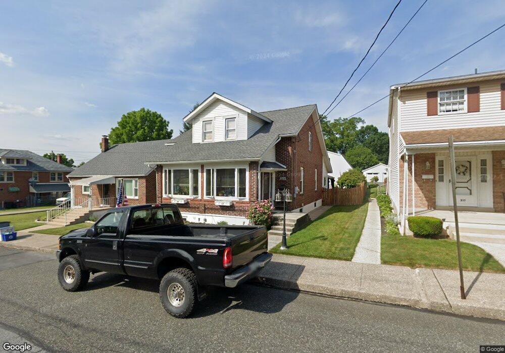
315 S 6th St Emmaus, PA 18049
Estimated Value: $265,000 - $344,000
3
Beds
2
Baths
1,237
Sq Ft
$239/Sq Ft
Est. Value
About This Home
This home is located at 315 S 6th St, Emmaus, PA 18049 and is currently estimated at $295,180, approximately $238 per square foot. 315 S 6th St is a home located in Lehigh County with nearby schools including Lincoln Elementary School, Lower Macungie Middle School, and Emmaus High School.
Ownership History
Date
Name
Owned For
Owner Type
Purchase Details
Closed on
Aug 30, 2019
Sold by
Nicholson Kenneth and Nicholson Brenda L
Bought by
Schaffer Matthew and Moser Lori
Current Estimated Value
Home Financials for this Owner
Home Financials are based on the most recent Mortgage that was taken out on this home.
Original Mortgage
$198,000
Outstanding Balance
$173,787
Interest Rate
3.7%
Mortgage Type
New Conventional
Estimated Equity
$121,393
Purchase Details
Closed on
Mar 21, 2002
Sold by
Nicholson Brenda L and Saunders Brenda L
Bought by
Nicholson Kenneth and Nicholson Brenda L
Purchase Details
Closed on
Jul 29, 1996
Sold by
Borkowski Michael W
Bought by
Saunders Brenda L
Purchase Details
Closed on
May 3, 1985
Sold by
Durback John and Durback Elizabeth
Bought by
Borkowski Michael W
Create a Home Valuation Report for This Property
The Home Valuation Report is an in-depth analysis detailing your home's value as well as a comparison with similar homes in the area
Home Values in the Area
Average Home Value in this Area
Purchase History
| Date | Buyer | Sale Price | Title Company |
|---|---|---|---|
| Schaffer Matthew | $220,000 | Home Settlement Services | |
| Nicholson Kenneth | -- | -- | |
| Saunders Brenda L | $72,500 | -- | |
| Borkowski Michael W | $56,000 | -- |
Source: Public Records
Mortgage History
| Date | Status | Borrower | Loan Amount |
|---|---|---|---|
| Open | Schaffer Matthew | $198,000 |
Source: Public Records
Tax History Compared to Growth
Tax History
| Year | Tax Paid | Tax Assessment Tax Assessment Total Assessment is a certain percentage of the fair market value that is determined by local assessors to be the total taxable value of land and additions on the property. | Land | Improvement |
|---|---|---|---|---|
| 2025 | $5,016 | $142,400 | $23,500 | $118,900 |
| 2024 | $4,595 | $142,400 | $23,500 | $118,900 |
| 2023 | $4,505 | $142,400 | $23,500 | $118,900 |
| 2022 | $4,357 | $142,400 | $118,900 | $23,500 |
| 2021 | $4,248 | $142,400 | $23,500 | $118,900 |
| 2020 | $4,211 | $142,400 | $23,500 | $118,900 |
| 2019 | $3,532 | $142,400 | $23,500 | $118,900 |
| 2018 | $3,944 | $142,400 | $23,500 | $118,900 |
| 2017 | $3,823 | $142,400 | $23,500 | $118,900 |
| 2016 | -- | $142,400 | $23,500 | $118,900 |
| 2015 | -- | $142,400 | $23,500 | $118,900 |
| 2014 | -- | $142,400 | $23,500 | $118,900 |
Source: Public Records
Map
Nearby Homes
- 521 Wood St
- 618 Broad St
- 659 Broad St
- 569 Chestnut St Unit 571
- 657 Walnut St
- 543 Long St
- 120 N 2nd St
- 118 N 2nd St
- 339 Delong Ave Unit 343
- 97 Chestnut Hill Rd
- 4109 Eveningstar Rd
- 3430 Gentlewind Way Unit IC 109
- 101 E George St
- 4088 Eveningstar Rd
- 2571 Brunner Rd
- 3623 Daylily Dr
- 558 Beechwood St
- 340 Chestnut Hill Rd
- 3810 Allen St
- 4160 Newport Dr