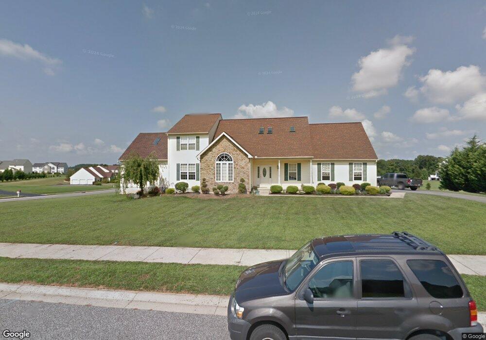
315 Wheatsheaf Dr New Castle, DE 19720
Kirkwood NeighborhoodEstimated Value: $611,000 - $736,000
4
Beds
4
Baths
3,169
Sq Ft
$217/Sq Ft
Est. Value
About This Home
This home is located at 315 Wheatsheaf Dr, New Castle, DE 19720 and is currently estimated at $687,873, approximately $217 per square foot. 315 Wheatsheaf Dr is a home located in New Castle County with nearby schools including Southern Elementary School, Gunning Bedford Middle School, and Aquinas Academy.
Ownership History
Date
Name
Owned For
Owner Type
Purchase Details
Closed on
Jul 26, 2002
Sold by
Intersect Development Inc
Bought by
Poore William E and Poore Nicole
Current Estimated Value
Home Financials for this Owner
Home Financials are based on the most recent Mortgage that was taken out on this home.
Original Mortgage
$178,000
Outstanding Balance
$75,805
Interest Rate
6.64%
Estimated Equity
$612,068
Create a Home Valuation Report for This Property
The Home Valuation Report is an in-depth analysis detailing your home's value as well as a comparison with similar homes in the area
Home Values in the Area
Average Home Value in this Area
Purchase History
| Date | Buyer | Sale Price | Title Company |
|---|---|---|---|
| Poore William E | $234,900 | -- |
Source: Public Records
Mortgage History
| Date | Status | Borrower | Loan Amount |
|---|---|---|---|
| Open | Poore William E | $178,000 |
Source: Public Records
Tax History Compared to Growth
Tax History
| Year | Tax Paid | Tax Assessment Tax Assessment Total Assessment is a certain percentage of the fair market value that is determined by local assessors to be the total taxable value of land and additions on the property. | Land | Improvement |
|---|---|---|---|---|
| 2024 | $4,921 | $139,500 | $16,200 | $123,300 |
| 2023 | $4,504 | $139,500 | $16,200 | $123,300 |
| 2022 | $4,688 | $139,500 | $16,200 | $123,300 |
| 2021 | $4,685 | $139,500 | $16,200 | $123,300 |
| 2020 | $4,715 | $139,500 | $16,200 | $123,300 |
| 2019 | $4,706 | $139,500 | $16,200 | $123,300 |
| 2018 | $4,640 | $139,500 | $16,200 | $123,300 |
| 2017 | $4,352 | $139,500 | $16,200 | $123,300 |
| 2016 | $3,886 | $139,500 | $16,200 | $123,300 |
| 2015 | $3,886 | $139,500 | $16,200 | $123,300 |
| 2014 | $3,907 | $139,500 | $16,200 | $123,300 |
Source: Public Records
Map
Nearby Homes
- 1119 Casey Dr
- 31 Crestpoint Dr
- 1049 Matthew Way
- 1225 Caitlin Way
- 6 Delaware St
- 2159 Mccoy Rd
- 1902 Mccoy Rd
- 402 Derrytown Dr
- 4010 Kirkwood Saint Georges Rd
- 35 N Dragon Dr
- 102 Parker Dr
- 8 Tamar Ct
- 300 Fenn Ct
- 121 Willow Oak Blvd
- 348 Starboard Dr
- 319 Pheasant Dr
- 616 Clifton Dr
- 210 Olivia Way
- 325 Howell School Rd
- 1239 Red Lion Rd
- 127 W Harvest Dr
- 501 Haystack Ln
- 126 W Harvest Dr
- 314 Wheatsheaf Dr
- 503 Haystack Ln
- 316 Wheatsheaf Dr
- 312 Wheatsheaf Dr
- 318 Wheatsheaf Dr
- 505 Haystack Ln
- 122 W Harvest Dr
- 320 Wheatsheaf Dr
- 120 W Harvest Dr
- 504 Haystack Ln
- 321 Wheatsheaf Dr
- 307 Wheatsheaf Dr
- 344 Wheatsheaf Dr
- 346 Wheatsheaf Dr
- 342 Wheatsheaf Dr
- 502 Haystack Ln
- 322 Wheatsheaf Dr