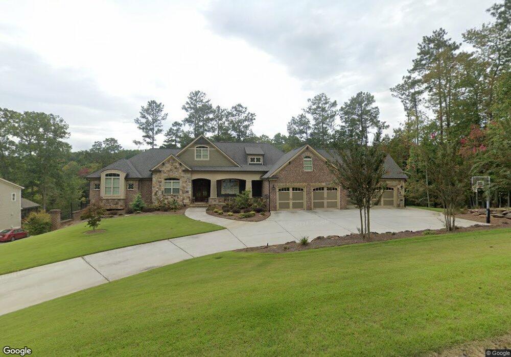
315 Wildwind Trace Dallas, GA 30132
Cedarcrest NeighborhoodEstimated Value: $728,000 - $980,371
5
Beds
7
Baths
3,155
Sq Ft
$260/Sq Ft
Est. Value
About This Home
This home is located at 315 Wildwind Trace, Dallas, GA 30132 and is currently estimated at $821,593, approximately $260 per square foot. 315 Wildwind Trace is a home with nearby schools including Burnt Hickory Elementary School, Sammy Mcclure Sr. Middle School, and North Paulding High School.
Ownership History
Date
Name
Owned For
Owner Type
Purchase Details
Closed on
Jul 11, 2024
Sold by
Whittemore Heath Blaine
Bought by
Whittemore Cristian
Current Estimated Value
Home Financials for this Owner
Home Financials are based on the most recent Mortgage that was taken out on this home.
Original Mortgage
$635,072
Outstanding Balance
$627,428
Interest Rate
6.95%
Mortgage Type
New Conventional
Estimated Equity
$194,165
Purchase Details
Closed on
May 27, 2016
Sold by
Maynard Robert E and Maynard Necia W
Bought by
Whittemore Heath Blaine and Whittemore Cristian Poss
Purchase Details
Closed on
Apr 13, 2000
Sold by
Totis Inc
Bought by
Maynard Robert E and Maynard Necia W
Home Financials for this Owner
Home Financials are based on the most recent Mortgage that was taken out on this home.
Original Mortgage
$50,575
Interest Rate
8.27%
Mortgage Type
New Conventional
Create a Home Valuation Report for This Property
The Home Valuation Report is an in-depth analysis detailing your home's value as well as a comparison with similar homes in the area
Home Values in the Area
Average Home Value in this Area
Purchase History
| Date | Buyer | Sale Price | Title Company |
|---|---|---|---|
| Whittemore Cristian | -- | -- | |
| Whittemore Heath Blaine | $66,500 | -- | |
| Maynard Robert E | $59,500 | -- |
Source: Public Records
Mortgage History
| Date | Status | Borrower | Loan Amount |
|---|---|---|---|
| Open | Whittemore Cristian | $635,072 | |
| Previous Owner | Maynard Robert E | $50,575 |
Source: Public Records
Tax History Compared to Growth
Tax History
| Year | Tax Paid | Tax Assessment Tax Assessment Total Assessment is a certain percentage of the fair market value that is determined by local assessors to be the total taxable value of land and additions on the property. | Land | Improvement |
|---|---|---|---|---|
| 2024 | $8,694 | $352,744 | $36,165 | $316,579 |
| 2023 | $9,130 | $352,744 | $30,000 | $322,744 |
| 2022 | $7,921 | $305,712 | $30,000 | $275,712 |
| 2021 | $7,024 | $243,580 | $30,000 | $213,580 |
| 2020 | $6,514 | $221,176 | $30,000 | $191,176 |
| 2019 | $5,295 | $177,600 | $30,040 | $147,560 |
| 2018 | $5,295 | $177,600 | $30,040 | $147,560 |
| 2017 | $6,363 | $208,280 | $36,000 | $172,280 |
| 2016 | $381 | $12,600 | $12,600 | $0 |
| 2015 | $388 | $12,600 | $12,600 | $0 |
| 2014 | $182 | $5,760 | $5,760 | $0 |
| 2013 | -- | $5,760 | $5,760 | $0 |
Source: Public Records
Map
Nearby Homes
- 365 Wildwind Trace
- 285 Wildwind Trace
- 350 Wildwind Trace
- 371 Wildwind Trace
- 105 Windlake Path
- 190 Wildwind Trace
- 389 Wildwind Trace
- 150 Wildwind Trace
- 400 Wildwind Trace
- 229 Wildwind Trace
- 125 Windlake Path
- 420 Wildwind Trace
- 420 Wildwind Trace Unit 76
- 0 Windlake Path
- 161 Wildwind Trace
- 425 Wildwind Trace
- 228 John Wesley Dr
- 228 John Wesley Dr
- 118 Wildwind Trace
- 175 Wildwind Trace