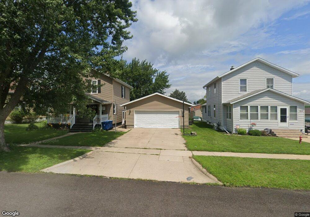
316 12th St de Witt, IA 52742
Estimated Value: $174,000 - $194,000
3
Beds
1
Bath
1,216
Sq Ft
$152/Sq Ft
Est. Value
About This Home
This home is located at 316 12th St, de Witt, IA 52742 and is currently estimated at $185,142, approximately $152 per square foot. 316 12th St is a home located in Clinton County with nearby schools including Ekstrand Elementary School, Central Dewitt Intermediate School, and Central Dewitt Middle School.
Ownership History
Date
Name
Owned For
Owner Type
Purchase Details
Closed on
Oct 12, 2018
Sold by
Blount Ronie M and Bount Sheryl C
Bought by
Newkirk Angela and Dochterman Darin
Current Estimated Value
Home Financials for this Owner
Home Financials are based on the most recent Mortgage that was taken out on this home.
Original Mortgage
$115,000
Outstanding Balance
$100,500
Interest Rate
4.6%
Mortgage Type
VA
Estimated Equity
$84,642
Purchase Details
Closed on
Sep 4, 2012
Sold by
Dawson Richard August and Dawson Richard A
Bought by
Kitchen John T and Kitchen Cathy J
Purchase Details
Closed on
Aug 7, 2012
Sold by
Dawson Richard A
Bought by
Dawson Richard August
Purchase Details
Closed on
Mar 19, 2012
Sold by
Mumm Sheryl C and Mumm Brian D
Bought by
Mumm Sheryl C
Purchase Details
Closed on
Jul 24, 2008
Sold by
Mumm Brian D and Spinner Sheryl C
Bought by
Mumm Sheryl C and Mumm Brain D
Home Financials for this Owner
Home Financials are based on the most recent Mortgage that was taken out on this home.
Original Mortgage
$93,380
Interest Rate
6.51%
Mortgage Type
FHA
Create a Home Valuation Report for This Property
The Home Valuation Report is an in-depth analysis detailing your home's value as well as a comparison with similar homes in the area
Home Values in the Area
Average Home Value in this Area
Purchase History
| Date | Buyer | Sale Price | Title Company |
|---|---|---|---|
| Newkirk Angela | $115,000 | -- | |
| Kitchen John T | $12,500 | None Available | |
| Dawson Richard August | -- | None Available | |
| Mumm Sheryl C | -- | Gomez Title & Closing | |
| Mumm Sheryl C | -- | Gomez Title And Closing Comp |
Source: Public Records
Mortgage History
| Date | Status | Borrower | Loan Amount |
|---|---|---|---|
| Open | Newkirk Angela | $115,000 | |
| Previous Owner | Mumm Sheryl C | $93,380 |
Source: Public Records
Tax History Compared to Growth
Tax History
| Year | Tax Paid | Tax Assessment Tax Assessment Total Assessment is a certain percentage of the fair market value that is determined by local assessors to be the total taxable value of land and additions on the property. | Land | Improvement |
|---|---|---|---|---|
| 2025 | $2,764 | $169,510 | $22,460 | $147,050 |
| 2024 | $2,764 | $160,510 | $22,460 | $138,050 |
| 2023 | $2,793 | $160,510 | $22,460 | $138,050 |
| 2022 | $2,128 | $143,000 | $22,460 | $120,540 |
| 2021 | $2,074 | $113,790 | $22,120 | $91,670 |
| 2020 | $2,074 | $105,820 | $22,120 | $83,700 |
| 2019 | $1,818 | $93,800 | $0 | $0 |
| 2018 | $1,770 | $93,800 | $0 | $0 |
| 2017 | $1,896 | $93,800 | $0 | $0 |
| 2016 | $1,814 | $0 | $0 | $0 |
| 2015 | $1,814 | $95,800 | $0 | $0 |
| 2014 | $1,838 | $95,800 | $0 | $0 |
| 2013 | $1,804 | $0 | $0 | $0 |
Source: Public Records
Map
Nearby Homes
- 201 12th St
- 1323 5th Ave
- 401 10th St
- 317 8th St
- 0 285th St Old Highway 61 Unit parcel 1808590000
- 285th Ave Old Hwy 61 Unit Parcel-1808600000/1
- 285th Ave Old Hwy 61 Unit Parcels 1808590000/
- 615 3rd Ave
- 1103 15th St
- 624 4th St
- 1016 5th St
- 510 2nd St
- 00 3rd St
- 1144 Brookview Dr
- 1527 11th St
- 306 13th Ave
- 119 14th Ave
- 106 14th Ave
- 615 S 6th Ave
- 302 Silver Creek Rd