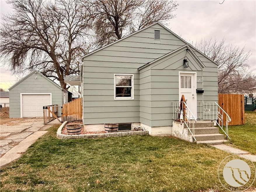
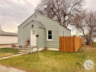
316 Durland Ave Laurel, MT 59044
Estimated payment $1,220/month
Highlights
- Mud Room
- Laundry Room
- Forced Air Heating System
- 1 Car Detached Garage
- Shed
- Ceiling Fan
About This Home
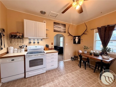
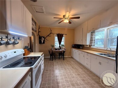
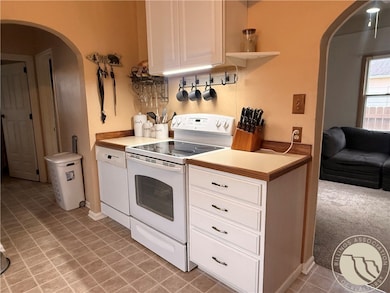
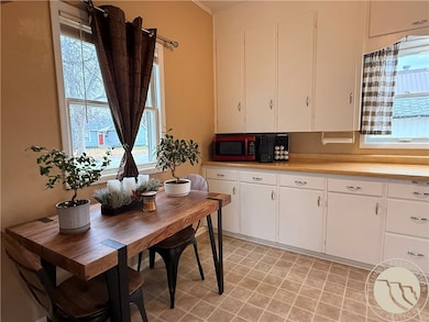
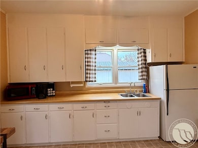
Neat as a pin and ready for its next owner!! Cozy and clean one level home with a larger, bright and open kitchen with good counter and cabinet space, an eating area and laundry/mud room. Large back yard is fenced with a newer privacy fence and a separate fenced dog area too. There is an oversized single car garage with opener and two storage sheds with the newer shed having storage room with built in shelving plus a separate workshop area too. Don't' miss this cute home that has a bigger feel and rooms that have adequate space! \
Listing Agent
Meridian Real Estate LLC Brokerage Phone: (406) 670-1746 License #RRE-BRO-LIC-53661 Listed on: 12/01/2025
Home Details
Home Type
- Single Family
Est. Annual Taxes
- $1,367
Year Built
- Built in 1920
Lot Details
- 7,200 Sq Ft Lot
- Fenced
- Level Lot
- Zoning described as Residential Multi-Family Restricted
Parking
- 1 Car Detached Garage
- Alley Access
- Garage Door Opener
Home Design
- Shingle Roof
- Asphalt Roof
Interior Spaces
- 664 Sq Ft Home
- 1-Story Property
- Ceiling Fan
- Window Treatments
- Mud Room
- Laundry Room
Kitchen
- Oven
- Free-Standing Range
- Dishwasher
Bedrooms and Bathrooms
- 1 Main Level Bedroom
- 1 Full Bathroom
Outdoor Features
- Shed
Schools
- Laurel Elementary And Middle School
- Laurel High School
Utilities
- No Cooling
- Forced Air Heating System
Community Details
- Yellowstone Subdivision
Listing and Financial Details
- Assessor Parcel Number B01269
Map
Home Values in the Area
Average Home Value in this Area
Tax History
| Year | Tax Paid | Tax Assessment Tax Assessment Total Assessment is a certain percentage of the fair market value that is determined by local assessors to be the total taxable value of land and additions on the property. | Land | Improvement |
|---|---|---|---|---|
| 2025 | $1,642 | $187,400 | $56,976 | $130,424 |
| 2024 | $1,642 | $158,800 | $37,025 | $121,775 |
| 2023 | $1,521 | $158,800 | $37,025 | $121,775 |
| 2022 | $1,218 | $116,400 | $0 | $0 |
| 2021 | $1,227 | $116,400 | $0 | $0 |
| 2020 | $1,143 | $107,600 | $0 | $0 |
| 2019 | $1,177 | $107,600 | $0 | $0 |
| 2018 | $1,059 | $94,500 | $0 | $0 |
| 2017 | $983 | $94,500 | $0 | $0 |
| 2016 | $1,001 | $97,400 | $0 | $0 |
| 2015 | $990 | $97,400 | $0 | $0 |
| 2014 | $1,036 | $54,272 | $0 | $0 |
Property History
| Date | Event | Price | List to Sale | Price per Sq Ft |
|---|---|---|---|---|
| 12/01/2025 12/01/25 | For Sale | $210,000 | -- | $316 / Sq Ft |
Purchase History
| Date | Type | Sale Price | Title Company |
|---|---|---|---|
| Trustee Deed | $40,000 | American Title & Escrow | |
| Warranty Deed | -- | None Available |
Mortgage History
| Date | Status | Loan Amount | Loan Type |
|---|---|---|---|
| Previous Owner | $55,969 | Purchase Money Mortgage |
Source: Billings Multiple Listing Service
MLS Number: 356736
APN: 03-0821-16-2-20-02-0000
Disclaimer: Certain information contained herein is derived from information provided by parties other than Homes.com. All information provided is deemed reliable, but is not guaranteed to be accurate and should be independently verified.
![]() IDX information is provided exclusively for personal, non-commercial use, and may not be used for any purpose other than to identify prospective properties consumers may be interested in purchasing. Information is deemed reliable but not guaranteed.
IDX information is provided exclusively for personal, non-commercial use, and may not be used for any purpose other than to identify prospective properties consumers may be interested in purchasing. Information is deemed reliable but not guaranteed.
- 419 Durland Ave
- 301 West Ave
- 211 Woodland Ave
- 116 4th Ave
- 711 Cougar Cir
- 110 E 5th St
- 516 Pennsylvania Ave
- 1508 Emerick Ln
- 801 E 4th St
- 717 E 5th St
- 717 E 5th, 506 Alder Ave
- 506 Alder Ave
- 1022 7th Ave
- 1003 Montana Ave
- 1036 9th Ave
- 1109 10th Ave
- 518 Date Ave
- TBD Block 3 Lot 9
- TBD Block 3 Lot 1
- 1013 Rochelle Dr
- 519 E 6th St
- 1015 Final Four Way
- 4510 Gators Way
- 4402 Blue Devils Way
- 920 Malibu Way
- 4215 Montana Sapphire Dr
- 4301 King Ave W
- 610 S 44th St W
- 610 S 44th St W
- 501 S 44th St W
- 4427 Altay Dr
- 4411 Dacha Dr
- 485 S 44th St W
- 3604 Decathlon Pkwy
- 3716 Decathlon Pkwy
- 3900 Victory Cir
- 4 Northglen Dr
- 3420 Granger Ave S Unit 14
- 115 Shiloh Rd
- 3290 Granger Ave E
