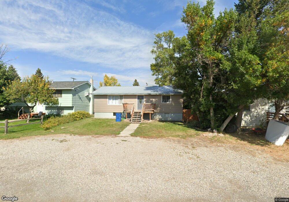
316 Hilger Ave Lewistown, MT 59457
Estimated Value: $254,000 - $308,957
3
Beds
2
Baths
960
Sq Ft
$296/Sq Ft
Est. Value
About This Home
This home is located at 316 Hilger Ave, Lewistown, MT 59457 and is currently estimated at $284,489, approximately $296 per square foot. 316 Hilger Ave is a home located in Fergus County with nearby schools including Fergus High School.
Ownership History
Date
Name
Owned For
Owner Type
Purchase Details
Closed on
Jun 13, 2023
Sold by
Your Montana Broker Inc
Bought by
Alderink Patricia
Current Estimated Value
Home Financials for this Owner
Home Financials are based on the most recent Mortgage that was taken out on this home.
Original Mortgage
$180,000
Outstanding Balance
$175,187
Interest Rate
6.39%
Mortgage Type
New Conventional
Estimated Equity
$109,302
Purchase Details
Closed on
Jan 10, 2023
Sold by
Inselman Orville L
Bought by
Your Montana Broker Inc
Purchase Details
Closed on
Sep 23, 2016
Sold by
Pirrie Colleen M
Bought by
Inselman Orville L
Home Financials for this Owner
Home Financials are based on the most recent Mortgage that was taken out on this home.
Original Mortgage
$144,337
Interest Rate
3.25%
Mortgage Type
FHA
Create a Home Valuation Report for This Property
The Home Valuation Report is an in-depth analysis detailing your home's value as well as a comparison with similar homes in the area
Home Values in the Area
Average Home Value in this Area
Purchase History
| Date | Buyer | Sale Price | Title Company |
|---|---|---|---|
| Alderink Patricia | -- | None Listed On Document | |
| Your Montana Broker Inc | -- | -- | |
| Inselman Orville L | $145,780 | Realty Title Inc |
Source: Public Records
Mortgage History
| Date | Status | Borrower | Loan Amount |
|---|---|---|---|
| Open | Alderink Patricia | $180,000 | |
| Previous Owner | Inselman Orville L | $144,337 |
Source: Public Records
Tax History Compared to Growth
Tax History
| Year | Tax Paid | Tax Assessment Tax Assessment Total Assessment is a certain percentage of the fair market value that is determined by local assessors to be the total taxable value of land and additions on the property. | Land | Improvement |
|---|---|---|---|---|
| 2025 | $2,096 | $287,900 | $0 | $0 |
| 2024 | $2,504 | $220,800 | $0 | $0 |
| 2023 | $2,512 | $220,800 | $0 | $0 |
| 2022 | $2,289 | $162,300 | $0 | $0 |
| 2021 | $1,876 | $162,300 | $0 | $0 |
| 2020 | $1,929 | $148,300 | $0 | $0 |
| 2019 | $1,916 | $148,300 | $0 | $0 |
| 2018 | $1,908 | $146,700 | $0 | $0 |
| 2017 | $1,655 | $146,700 | $0 | $0 |
| 2016 | $1,418 | $107,530 | $0 | $0 |
| 2015 | $1,196 | $107,530 | $0 | $0 |
| 2014 | $1,155 | $58,247 | $0 | $0 |
Source: Public Records
Map
Nearby Homes
- NHN Truck Bypass
- NHN A St
- TBD Truck Bypass
- 35 acres Truck Bypass
- 414 Warr St
- 501 Wright St
- 412 W Huron St
- 105 Hillcrest Dr
- 1014 Mountain View Dr
- 313 W Idaho St
- 316 W Corcoran St
- 318 W Evelyn St
- 0 Tbd Unit 20682760
- 0 Tbd Unit 11290776
- 628 Mountain View Dr
- 632 Mountain View Dr
- 514 2nd Ave N
- 624 W Broadway St
- 1011 W Broadway St
- 115 7th Ave N
- 312 Hilger Ave
- 320 Hilger Ave
- 306 3rd St W
- 919 Truck Bypass
- 316 3rd St W
- 317 Hilger Ave
- 307 Hilger Ave
- 307 Hilger Ave Unit Lewistown
- 921 Truck Bypass
- 305 Hilger Ave
- 212 3rd St W
- 310 7th Ave W
- 308 7th Ave W
- 202 3rd St W
- 221 Hilger Ave
- 201 3rd St W
- 226 6th St W
- 317 7th Ave W
- 307 7th Ave W
- 104 3rd St W