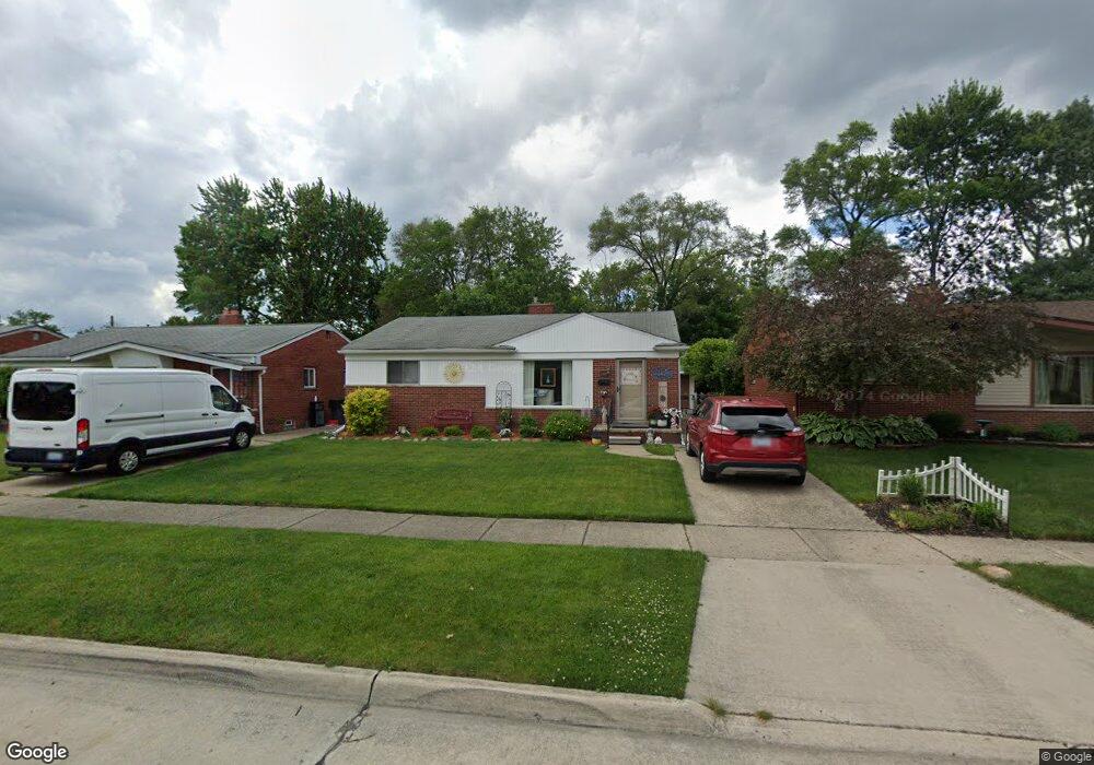
31600 Mackenzie Dr Westland, MI 48185
Estimated Value: $262,000 - $294,000
--
Bed
1
Bath
1,572
Sq Ft
$177/Sq Ft
Est. Value
About This Home
This home is located at 31600 Mackenzie Dr, Westland, MI 48185 and is currently estimated at $277,969, approximately $176 per square foot. 31600 Mackenzie Dr is a home located in Wayne County with nearby schools including Hayes Elementary School, Emerson Middle School, and Cooper Upper Elementary School.
Ownership History
Date
Name
Owned For
Owner Type
Purchase Details
Closed on
Jan 16, 2024
Sold by
Sands Evelyn
Bought by
Sands Evelyn and Train Gail A
Current Estimated Value
Home Financials for this Owner
Home Financials are based on the most recent Mortgage that was taken out on this home.
Original Mortgage
$53,800
Outstanding Balance
$52,859
Interest Rate
6.95%
Mortgage Type
New Conventional
Estimated Equity
$225,110
Create a Home Valuation Report for This Property
The Home Valuation Report is an in-depth analysis detailing your home's value as well as a comparison with similar homes in the area
Home Values in the Area
Average Home Value in this Area
Purchase History
| Date | Buyer | Sale Price | Title Company |
|---|---|---|---|
| Sands Evelyn | -- | Covius Settlement Services | |
| Sands Evelyn | -- | Covius Settlement Services |
Source: Public Records
Mortgage History
| Date | Status | Borrower | Loan Amount |
|---|---|---|---|
| Open | Sands Evelyn | $53,800 | |
| Closed | Sands Evelyn | $53,800 |
Source: Public Records
Tax History Compared to Growth
Tax History
| Year | Tax Paid | Tax Assessment Tax Assessment Total Assessment is a certain percentage of the fair market value that is determined by local assessors to be the total taxable value of land and additions on the property. | Land | Improvement |
|---|---|---|---|---|
| 2025 | $2,609 | $142,600 | $0 | $0 |
| 2024 | $2,609 | $131,600 | $0 | $0 |
| 2023 | $2,491 | $119,200 | $0 | $0 |
| 2022 | $2,885 | $103,400 | $0 | $0 |
| 2021 | $2,814 | $98,600 | $0 | $0 |
| 2020 | $2,783 | $93,500 | $0 | $0 |
| 2019 | $2,650 | $89,400 | $0 | $0 |
| 2018 | $2,103 | $73,200 | $0 | $0 |
| 2017 | $934 | $68,300 | $0 | $0 |
| 2016 | $2,532 | $68,700 | $0 | $0 |
| 2015 | $5,120 | $64,320 | $0 | $0 |
| 2013 | $4,960 | $50,760 | $0 | $0 |
| 2012 | $2,234 | $50,920 | $0 | $0 |
Source: Public Records
Map
Nearby Homes
- 31273 Mackenzie Dr
- 31244 Stephen Ave
- 8238 Terri Dr
- 8824 Nevada St
- 32047 Anita Dr
- 8878 Merriman Rd
- 8332 Berwick Dr
- 31640 Ann Arbor Trail
- 9085 Melrose St
- 8226 Huntington St Unit 24
- 8226 Huntington St Unit 25
- 32327 Washington St
- 32451 Sandra Ln
- 7814 Terri Dr
- 9212 Idaho St
- 31171 Grandon St Unit 56
- 9253 Idaho St
- 32725 Joy Rd
- 32724 Hees St
- 8346 Hillcrest Blvd
- 31590 Mackenzie Dr
- 31610 Mackenzie Dr
- 31580 Mackenzie Dr
- 31620 Mackenzie Dr
- 8610 Alper St
- 8620 Alper St
- 8600 Alper St
- 31630 Mackenzie Dr
- 8630 Alper St
- 8570 Alper St Unit Bldg-Unit
- 8570 Alper St
- 31570 Mackenzie Dr
- 31603 Mackenzie Dr
- 31591 Mackenzie Dr
- 8640 Alper St
- 8560 Alper St
- 31640 Mackenzie Dr
- 31577 Mackenzie Dr
- 31627 Mackenzie Dr
- 31560 Mackenzie Dr