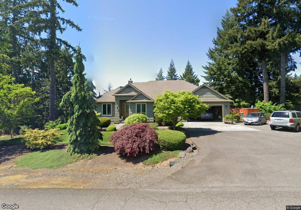
31735 SW Callahan Rd Scappoose, OR 97056
Estimated Value: $771,801 - $1,024,000
3
Beds
2
Baths
2,088
Sq Ft
$423/Sq Ft
Est. Value
About This Home
This home is located at 31735 SW Callahan Rd, Scappoose, OR 97056 and is currently estimated at $882,950, approximately $422 per square foot. 31735 SW Callahan Rd is a home located in Columbia County with nearby schools including Scappoose High School.
Ownership History
Date
Name
Owned For
Owner Type
Purchase Details
Closed on
May 21, 2024
Sold by
Dickson Lonnie G and Dickson Molly J
Bought by
Dickson Family Trust and Dickson
Current Estimated Value
Purchase Details
Closed on
Aug 15, 2005
Sold by
Hillcrest Investments Ltd
Bought by
Dickson Lonnie G and Dickson Molly J
Create a Home Valuation Report for This Property
The Home Valuation Report is an in-depth analysis detailing your home's value as well as a comparison with similar homes in the area
Home Values in the Area
Average Home Value in this Area
Purchase History
| Date | Buyer | Sale Price | Title Company |
|---|---|---|---|
| Dickson Family Trust | -- | None Listed On Document | |
| Dickson Lonnie G | $115,000 | Ticor Title |
Source: Public Records
Tax History Compared to Growth
Tax History
| Year | Tax Paid | Tax Assessment Tax Assessment Total Assessment is a certain percentage of the fair market value that is determined by local assessors to be the total taxable value of land and additions on the property. | Land | Improvement |
|---|---|---|---|---|
| 2025 | $8,607 | $644,240 | $252,440 | $391,800 |
| 2024 | $8,361 | $625,480 | $245,080 | $380,400 |
| 2023 | $8,324 | $607,270 | $230,330 | $376,940 |
| 2022 | $7,950 | $589,590 | $198,460 | $391,130 |
| 2021 | $7,726 | $572,420 | $201,410 | $371,010 |
| 2020 | $7,090 | $555,750 | $225,240 | $330,510 |
| 2019 | $6,912 | $539,570 | $218,681 | $320,889 |
| 2018 | $6,726 | $523,860 | $199,320 | $324,540 |
| 2017 | $6,627 | $508,610 | $193,510 | $315,100 |
| 2016 | $6,570 | $493,800 | $187,870 | $305,930 |
| 2015 | $6,170 | $479,420 | $173,160 | $306,260 |
| 2014 | $5,579 | $441,940 | $166,010 | $275,930 |
Source: Public Records
Map
Nearby Homes
- 0 Hawthorne Unit 8 23537227
- 0 Hawthorne Unit 10 23372609
- 0 Hawthorne Unit 9 23026376
- 0 Hemlock Ave Unit 120247766
- 0 Callahan Unit 28 23508167
- 0 Callahan Unit 26 23220367
- 0 Callahan Unit 27
- 24 Callahan
- 4 Briarwood Dr Unit 4
- 50322 Briarwood Ct
- 21400 NW Watson Rd
- Hillsdale Plan at Dutch Canyon
- Aubrey Plan at Dutch Canyon
- Carmichael Plan at Dutch Canyon
- Carlton Plan at Dutch Canyon
- 51557 SW Em Watts Rd
- 33362 SW Rokin Way
- 33366 SW Rokin Way
- 33340 SW Rokin Way
- 51350 SW Randstad St
- 31765 SW Callahan Rd
- 31750 SW Callahan Rd
- 31762 SW Callahan Rd
- 31880 Moon Ridge Ct
- 31863 Moon Ridge Ct
- 31874 Moon Ridge Ct
- 31870 Moon Ridge Ct
- 31772 SW Callahan Rd
- 50500 Maple Meadows Ave
- 0 Maple Meadows Unit Lot 6 19040573
- 0 Maple Meadows Unit 2 19593941
- 0 Maple Meadows Unit 3 19277791
- 0 Callahan Unit 24623898
- 50633 Hemlock Ave
- 50475 Maple Meadows Ave
- 4 Maple Meadows Unit 4
- 31967 Wayside Ct
- 50725 Hemlock Ave
- 50411 Maple Meadows Ave
- 8 Maple Meadows Unit 8