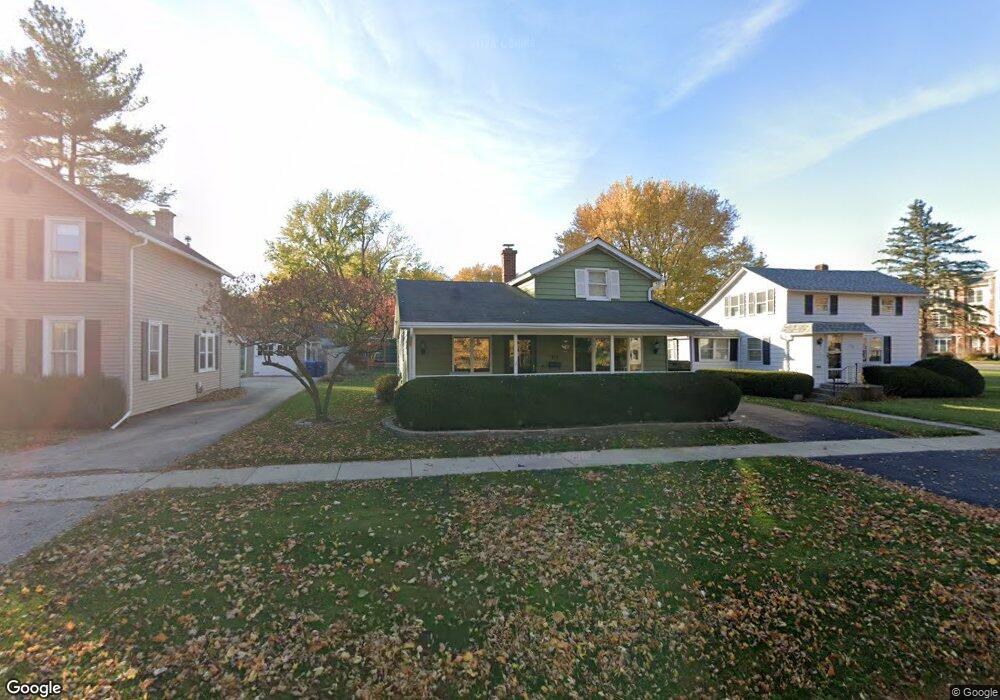
318 N 1st St Geneva, IL 60134
Downtown Geneva NeighborhoodEstimated Value: $347,071 - $417,000
2
Beds
1
Bath
1,128
Sq Ft
$328/Sq Ft
Est. Value
About This Home
This home is located at 318 N 1st St, Geneva, IL 60134 and is currently estimated at $369,768, approximately $327 per square foot. 318 N 1st St is a home located in Kane County with nearby schools including Williamsburg Elementary School, Geneva Community High School, and St. Peter School.
Ownership History
Date
Name
Owned For
Owner Type
Purchase Details
Closed on
Jun 11, 2007
Sold by
Pikula Jo Ann
Bought by
Petrosa Stephen and Petrosa Linda
Current Estimated Value
Purchase Details
Closed on
May 2, 2007
Sold by
Pikula Jo Ann
Bought by
Petrosa Stephen and Petrosa Linda
Purchase Details
Closed on
Jul 8, 2002
Sold by
Petrosa Stephen and Petrosa Linda
Bought by
Pikula Jo Ann
Purchase Details
Closed on
May 1, 2001
Sold by
Petrosa Michael J
Bought by
Petrosa Michael J and Michael J Petrosa Declaration Of Trust
Create a Home Valuation Report for This Property
The Home Valuation Report is an in-depth analysis detailing your home's value as well as a comparison with similar homes in the area
Home Values in the Area
Average Home Value in this Area
Purchase History
| Date | Buyer | Sale Price | Title Company |
|---|---|---|---|
| Petrosa Stephen | -- | None Available | |
| Petrosa Stephen | -- | None Available | |
| Pikula Jo Ann | -- | -- | |
| Petrosa Stephen | -- | -- | |
| Petrosa Michael J | -- | -- |
Source: Public Records
Tax History Compared to Growth
Tax History
| Year | Tax Paid | Tax Assessment Tax Assessment Total Assessment is a certain percentage of the fair market value that is determined by local assessors to be the total taxable value of land and additions on the property. | Land | Improvement |
|---|---|---|---|---|
| 2024 | $6,305 | $98,858 | $35,954 | $62,904 |
| 2023 | $6,060 | $89,870 | $32,685 | $57,185 |
| 2022 | $5,465 | $76,450 | $30,371 | $46,079 |
| 2021 | $5,280 | $73,608 | $29,242 | $44,366 |
| 2020 | $5,210 | $72,485 | $28,796 | $43,689 |
| 2019 | $5,183 | $71,113 | $28,251 | $42,862 |
| 2018 | $5,019 | $69,295 | $28,251 | $41,044 |
| 2017 | $4,945 | $67,447 | $27,498 | $39,949 |
| 2016 | $4,801 | $64,763 | $27,126 | $37,637 |
| 2015 | -- | $61,573 | $25,790 | $35,783 |
| 2014 | -- | $60,871 | $25,790 | $35,081 |
| 2013 | -- | $60,871 | $25,790 | $35,081 |
Source: Public Records
Map
Nearby Homes
- 515 Peyton St
- 108 S River Ln
- 518 Illinois St
- 213 S 5th St
- 57 S 7th St
- 835 N Bennett St
- 839 N Bennett St
- 315 S 5th St
- 802 Union St
- 228 Crissey Ave
- LOT 209 Austin Ave
- 57 White Oak Cir
- 82 Gray St
- 221 Campbell Ct
- 609 Mckinley Ave
- 246 Kenston Ct Unit 246
- 800 Anderson Blvd
- 629 N Lincoln Ave
- 1719 S 4th Place
- 1211 James St